
临洮县 topographic map
Interactive map
Click on the map to display elevation.
About this map
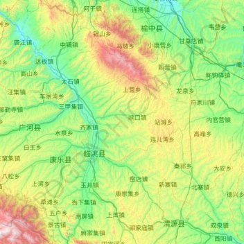
Name: 临洮县 topographic map, elevation, terrain.
Location: 临洮县, 定西市, 甘肃省, 730512, 中国 (35.06147 103.46630 35.94633 104.32647)
Average elevation: 7,395 ft
Minimum elevation: 5,673 ft
Maximum elevation: 13,337 ft
Other topographic maps
Click on a map to view its topography, its elevation and its terrain.