
碌曲县 topographic map
Interactive map
Click on the map to display elevation.
About this map
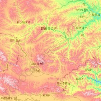
Name: 碌曲县 topographic map, elevation, terrain.
Location: 碌曲县, 甘南藏族自治州, 甘肃省, 中国 (33.96825 102.00703 34.82681 102.97066)
Average elevation: 11,545 ft
Minimum elevation: 9,081 ft
Maximum elevation: 14,692 ft
全县海拔在3000~4000米之间,平均海拔3500米。西部是高原山地,东部洮河两岸山岭陡峭,河谷是主要的农业种植区。
Other topographic maps
Click on a map to view its topography, its elevation and its terrain.