
Chandigarh topographic map
Interactive map
Click on the map to display elevation.
Chandigarh
Chandigarh is located by the foothills of the Shivalik Range of the Himalayas in northwest India. It covers an area of approximately 114 km2. It borders the states of Punjab and Haryana. The exact geographic coordinates of Chandigarh are 30°44′N 76°47′E / 30.74°N 76.79°E / 30.74; 76.79. It has an average elevation of 321 metres (1053 ft).
About this map
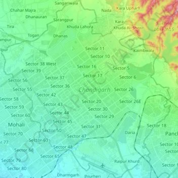
Name: Chandigarh topographic map, elevation, terrain.
Location: Chandigarh, India (30.66497 76.70499 30.79495 76.84903)
Average elevation: 1,125 ft
Minimum elevation: 984 ft
Maximum elevation: 1,677 ft
Other topographic maps
Click on a map to view its topography, its elevation and its terrain.
Bengaluru
India > Karnataka > Bangalore North
Bangalore (/ˈbæŋɡəlɔːr, ˌbæŋɡəˈlɔːr/ BANG-gə-lor, -LOR), officially Bengaluru (Kannada: [ˈbeŋɡɐɭuːɾu] ; ISO: Beṁgaḷūru), is the capital and largest city of the southern Indian state of Karnataka. It has a population of more than 8 million and a metropolitan population of around…
Average elevation: 2,884 ft
Guntakal
India > Andhra Pradesh > Guntakal
Guntakal is located at 15°10′N 77°23′E / 15.17°N 77.38°E / 15.17; 77.38. It has an average elevation of 432 metres (1,417 ft).
Average elevation: 1,460 ft
Kohima
India > Nagaland > Kohima Sadar
Kohima (/koʊˈhiːmə/ ; Angami Naga: Kewhira (IPA: [ˈkɛʍɪɻə])) is the capital of the North East Indian state of Nagaland. With a resident population of almost 100,000, it is the second largest city in the state. Kohima constitutes both a district and a municipality. The municipality covers 20 km2 (7.7…
Average elevation: 4,675 ft
Ujjain
India > Madhya Pradesh > Ujjain NagarTahsil
Ujjain is located in the west-central part of India, and is north of the upper limit of the Vindhya mountain ranges. Located on the Malwa plateau, it is higher than the north Indian plains and the land rises towards the Vindhya Range to the south. Ujjain's coordinates are 23°10′N 75°46′E /…
Average elevation: 1,644 ft
Amarkantak
India > Madhya Pradesh > Pushparajgarh Tehsil
Amarkantak is located in Madhya Pradesh in India at 22°40′N 81°45′E / 22.67°N 81.75°E / 22.67; 81.75. It has an average elevation of 1,048 m (3,438 ft). Roads running through Rewa, Shahdol, Anuppur, Jabalpur, Katni, Bilaspur and Gaurella connect it. The nearest railway stations are Pendra Road…
Average elevation: 2,900 ft
Adimali
Adimaly generally has a cool climate throughout the year, typical of the higher altitudes, though not as cold as Munnar. Temperatures rarely exceed 26 degrees and never drop below 10 degrees as it usually stays around 17-24 degrees. Though December–January are comparatively cooler than other months. Adimaly…
Average elevation: 2,579 ft
Shrivardhan Fort
India > Maharashtra > Mawal > Udhewadi > Vanati Kakurwardi
Average elevation: 1,749 ft
Mandapam
India > Tamil Nadu > Ramanathapuram
Mandapam is located at 9°17′N 79°07′E / 9.28°N 79.12°E / 9.28; 79.12. It has an average elevation of 9 metres (29 feet).
Average elevation: 3 ft
Chengalpattu
India > Tamil Nadu > Chengalpattu
Chengalpattu is located at 12°42′N 79°59′E / 12.7°N 79.98°E / 12.7; 79.98. It has an average elevation of 36 metres (118 ft). Lake Kolavai is the largest located in Chengalpattu.
Average elevation: 157 ft
Kotli
India > Himachal Pradesh > Kotli
Kotli Tungal (Kotli) is a small town in Himachal Pradesh, in northern India located along national highway 70 (updated 003) which connects Jalandhar (in Punjab) to Mandi. It is 22 km (14 mi) from the town of Mandi, Kotli is a Sub Division and Tehsil (Sub District) of Mandi District. Kotli and the surrounding…
Average elevation: 3,917 ft
Suratgarh
India > Rajasthan > Suratgarh Tehsil
Suratgarh is located at 29°19′04″N 73°53′56″E / 29.317701°N 73.898935°E / 29.317701; 73.898935. It has an average elevation of 168 metres (551) feet. It is a Northern Part of Thar desert. Seasonal Ghaghar river runs through Northern part of tehsil. Suratgarh has Greenary in Northern part…
Average elevation: 581 ft
Bargarh
Bargarh is located in Western Odisha, close to the border of neighboring state of Chhattisgarh. It is positioned at 21°20′N 83°37′E / 21.33°N 83.62°E / 21.33; 83.62 with an average elevation of 171 meter (561 feet). The Bargarh district lies in the Plain with Eastern Ghats running close to the…
Average elevation: 568 ft
Barren Island
India > Andaman and Nicobar Islands
This volcanic island stands in the midst of a volcanic belt on the edge of the Indian and Burmese tectonic plates. Narcondam Island is a dormant volcano in the area, apart from volcanic seamounts like Alcock and Sewell. All the historical and recent eruptions (1789 and after) are confined within and around an…
Average elevation: 354 ft
Karad
India > Maharashtra > Karad
Karad is located at 17°17′N 74°12′E / 17.28°N 74.2°E / 17.28; 74.2. It has an average elevation of 566 metres (1857 feet). Karad is located near Agashiva caves 17°14′15″N 74°09′07″E / 17.237506°N 74.15205°E / 17.237506; 74.15205.
Average elevation: 1,903 ft
Phulbani
India > Odisha > Phulabani Town
Phulbani is located at 20°28′N 84°14′E / 20.47°N 84.23°E / 20.47; 84.23. It has an average elevation of 485 metres (1591 feet).
Average elevation: 1,703 ft
Giingee
India > Tamil Nadu > Gingee
Gingee is located at 12°15′N 79°25′E / 12.25°N 79.42°E / 12.25; 79.42. It has an average elevation of 92 metres (301 ft).
Average elevation: 335 ft
Ponmudi
India > Kerala > Nedumangad
Ponmudi (the Golden Peak) is a hill station in the Peringamala gramapanchayath of Thiruvananthapuram district of Kerala in India. It is located 22km west of Vithura town, 53 km north-east of Thiruvananthapuram City, 78 km south-east of Varkala town and 69 km north-east of Kovalam Beach at an altitude of 1,100…
Average elevation: 2,208 ft
Udaipur
India > Rajasthan > Girwa Tehsil
Udaipur is located at 24°31′30″N 73°40′38″E / 24.525049°N 73.677116°E / 24.525049; 73.677116. The city covers an area of 64 km2 (25 sq mi) and lies at an altitude of 598.00 m (1,962 ft) above sea level. It is located in the southern region of Rajasthan, near the Gujarat border. The city…
Average elevation: 2,152 ft
Ichalkaranji
India > Maharashtra > Hatkanangle
Ichalkaranji is located at 16°42′N 74°28′E / 16.7°N 74.47°E / 16.7; 74.47. It has an average elevation of 538 metres (1768 ft).
Average elevation: 1,844 ft
Kundagola
India > Karnataka > Kundagola taluku
Kundgol is located at 15°15′N 75°15′E / 15.25°N 75.25°E / 15.25; 75.25. It has an average elevation of 615 metres (2017 feet).
Average elevation: 2,051 ft