Geolocate

Emmet County topographic map

Interactive map

Click on the map to display elevation.

About this map

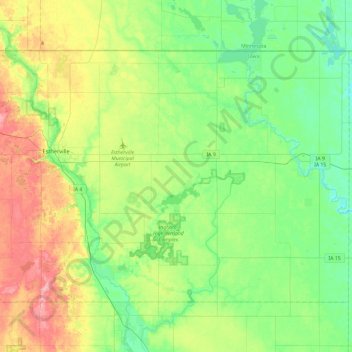
Name: Emmet County topographic map, elevation, terrain.

Location: Emmet County, Iowa, United States (43.25500 -94.91484 43.50107 -94.44233)

Average elevation: 1,302 ft

Minimum elevation: 1,181 ft

Maximum elevation: 1,549 ft

Iowa trails, hiking, mountain biking, running and outdoor activities

Other topographic maps

Click on a map to view its topography, its elevation and its terrain.

Discord

United States > Iowa > Woodbury County

Average elevation: 1,165 ft

East Ottumwa

United States > Iowa > Wapello County > Ottumwa

Average elevation: 689 ft

Buffalo Township

United States > Iowa > Scott County

Average elevation: 686 ft

North Cedar

United States > Iowa > Black Hawk County > Cedar Falls

Average elevation: 883 ft

Mona

United States > Iowa > Mitchell County

Average elevation: 1,181 ft

Clark

United States > Iowa > Mills County

Average elevation: 1,030 ft

Hawkeye Point

United States > Iowa > Osceola County

Average elevation: 1,634 ft

Garden City

United States > Iowa > Hardin County

Average elevation: 1,178 ft

Gifford

United States > Iowa > Hardin County

Average elevation: 971 ft

Yorkshire

United States > Iowa > Harrison County

Average elevation: 1,207 ft

Cooper

United States > Iowa > Greene County

Average elevation: 1,066 ft

City of Coon Rapids

United States > Iowa > Guthrie County

Average elevation: 1,106 ft

Adair/Finnegan Dam

United States > Iowa > Guthrie County

Average elevation: 1,138 ft

Percival

United States > Iowa > Fremont County

Average elevation: 928 ft

Kilbourn

United States > Iowa > Van Buren County

Average elevation: 656 ft

McPaul

United States > Iowa > Fremont County

Average elevation: 935 ft

Oran

United States > Iowa > Fayette County

Average elevation: 1,030 ft

Saint Lucas

United States > Iowa > Fayette County > St. Lucas

Average elevation: 1,112 ft

Anderson

United States > Iowa > Fremont County

Average elevation: 991 ft

Bartlett

United States > Iowa > Fremont County

Average elevation: 945 ft

Booneville

United States > Iowa > Dallas County

Average elevation: 892 ft

Chapin

United States > Iowa > Franklin County

Average elevation: 1,135 ft

Bradford

United States > Iowa > Franklin County

Average elevation: 1,240 ft

Crocker

United States > Iowa > Polk County

Average elevation: 968 ft

Gridley

United States > Iowa > Emmet County

Average elevation: 1,270 ft

Chequest

United States > Iowa > Davis County

Average elevation: 761 ft

Ash Grove

United States > Iowa > Davis County

Average elevation: 810 ft

Troy

United States > Iowa > Davis County

Average elevation: 778 ft

West Grove

United States > Iowa > Davis County

Average elevation: 922 ft

Finchford

United States > Iowa > Black Hawk County

Average elevation: 906 ft

Freeport

United States > Iowa > Winneshiek County

Average elevation: 981 ft

Centerville

United States > Iowa > Boone County

Average elevation: 1,030 ft

Dewar

United States > Iowa > Black Hawk County

Average elevation: 915 ft

Austinville

United States > Iowa > Butler County

Average elevation: 1,024 ft

Irving

United States > Iowa > Benton County

Average elevation: 850 ft

Washburn

United States > Iowa > Black Hawk County

Average elevation: 846 ft

Benson

United States > Iowa > Black Hawk County

Average elevation: 938 ft

Dorchester

United States > Iowa > Allamakee County

Average elevation: 984 ft

Watkins

United States > Iowa > Benton County

Average elevation: 833 ft

Eagle Center

United States > Iowa > Black Hawk County

Average elevation: 928 ft

Voorhies

United States > Iowa > Black Hawk County

Average elevation: 994 ft

Saylorville

United States > Iowa > Polk County

Average elevation: 873 ft

Amish

United States > Iowa > Johnson County

Average elevation: 735 ft

Kesley

United States > Iowa > Butler County

Average elevation: 1,001 ft

Elon

United States > Iowa > Allamakee County

Average elevation: 1,099 ft

Toddville

United States > Iowa > Linn County

Average elevation: 833 ft

Reactor Woods

United States > Iowa > Story County > Ames

Average elevation: 958 ft

Carroll County

United States > Iowa

Average elevation: 1,093 ft

York

United States > Iowa > Delaware County

Average elevation: 1,115 ft

Scott Avenue Dam

United States > Iowa > Polk County > Des Moines

Average elevation: 810 ft

Green Island

United States > Iowa > Jackson County

Average elevation: 663 ft

Galesburg

United States > Iowa > Jasper County

Average elevation: 840 ft

City of Coon Rapids

United States > Iowa > Guthrie County

Average elevation: 1,132 ft

Cedar Valley

United States > Iowa > Cedar County

Average elevation: 751 ft

Hanford

United States > Iowa > Cerro Gordo County

Average elevation: 1,184 ft

Sheridan Township

United States > Iowa > Scott County

Average elevation: 758 ft

Saylor

United States > Iowa > Polk County

Average elevation: 869 ft

Ledges State Park

United States > Iowa > Boone County

Average elevation: 1,010 ft

Brookside Park

United States > Iowa > Story County > Ames

Average elevation: 932 ft

Rock Creek

United States > Iowa > Cedar County

Average elevation: 771 ft

Blackhawk

United States > Iowa > Davis County

Average elevation: 797 ft

Cedar Rapids

United States > Iowa > Linn County > Cedar Rapids

Average elevation: 817 ft

Indianapolis

United States > Iowa > Mahaska County

Average elevation: 781 ft

New Era

United States > Iowa > Muscatine County

Average elevation: 682 ft

Yampa

United States > Iowa > Wapello County

Average elevation: 774 ft

Des Moines

United States > Iowa > Polk County > Des Moines

Average elevation: 889 ft

Black Hawk

United States > Iowa

Average elevation: 991 ft

Black Hawk Lake

United States > Iowa > Sac County > Lake View

Average elevation: 1,227 ft

Stephenson Park

United States > Iowa > Henry County > Lowell

Average elevation: 620 ft

Sioux City

United States > Iowa > Woodbury County > Sioux City

Average elevation: 1,184 ft

Ozark

United States > Iowa > Jackson County

Average elevation: 873 ft

Waterloo

United States > Iowa > Black Hawk County > Waterloo

The average elevation of Waterloo is 846 feet above sea level. The population density is 1101 people per square mile, considered low for an urban area.

Average elevation: 925 ft

Iowa City

United States > Iowa > Johnson County > Iowa City

The elevation at the Iowa City Municipal Airport is 668 ft (203.6 m) above sea level.

Average elevation: 738 ft

Pella

United States > Iowa > Marion County > Pella

Average elevation: 830 ft

Dubuque

United States > Iowa > Dubuque County > Dubuque

Average elevation: 866 ft

Cresco

United States > Iowa > Howard County > Cresco

Average elevation: 1,247 ft

Ames

United States > Iowa > Story County > Ames

Average elevation: 1,010 ft

West Union

United States > Iowa > Fayette County > West Union

Average elevation: 1,171 ft

Corning

United States > Iowa > Adams County > Corning

Average elevation: 1,204 ft

Kirkman

United States > Iowa > Shelby County > Kirkman > Kirkman

Average elevation: 1,289 ft

Packwood

United States > Iowa > Jefferson County > Packwood > Packwood

Average elevation: 804 ft

Underwood

United States > Iowa > Pottawattamie County > Underwood > Underwood

Average elevation: 1,129 ft

George

United States > Iowa > Lyon County > George

Average elevation: 1,385 ft

Stacyville

United States > Iowa > Mitchell County > Stacyville

Average elevation: 1,220 ft

Kellogg

United States > Iowa > Jasper County > Kellogg > Kellogg

Average elevation: 886 ft

Mount Pleasant

United States > Iowa > Henry County > Mount Pleasant > Mount Pleasant

The Mount Pleasant Municipal Airport (FAA Identifier: MPZ) is at an elevation of 730 ft (222.5 m) and is located 3 miles (4.8 km) southeast of the city. The airport started operations in March 1945. As of May 2014 it has 2 runways: Runway 15/33 is hard surfaced (asphalt) and is 4001 ft long × 75 ft wide (1220…

Average elevation: 702 ft

Ackworth

United States > Iowa > Warren County > Ackworth

Average elevation: 856 ft

Bertram

United States > Iowa > Linn County > Bertram > Bertram

Average elevation: 758 ft

Portland

United States > Iowa > Cerro Gordo County > Portland

Average elevation: 1,096 ft

Lenox

United States > Iowa > Taylor County > Lenox

Average elevation: 1,276 ft

Littleton

United States > Iowa > Buchanan County

Average elevation: 951 ft

Cushing

United States > Iowa > Woodbury County > Cushing > Cushing

Average elevation: 1,329 ft

Silver City

United States > Iowa > Mills County > Silver City > Silver City

Average elevation: 1,115 ft

Elliott

United States > Iowa > Montgomery County > Elliott > Elliott

Average elevation: 1,096 ft

Central City

United States > Iowa > Linn County > Central City

Average elevation: 883 ft

Pleasantville

United States > Iowa > Marion County > Pleasantville

Average elevation: 889 ft