
Freedom Ridge topographic map
Interactive map
Click on the map to display elevation.
About this map
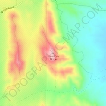
Name: Freedom Ridge topographic map, elevation, terrain.
Location: Freedom Ridge, Lincoln County, Nevada, United States (37.33480 -115.64442 37.33490 -115.64432)
Average elevation: 5,243 ft
Minimum elevation: 4,977 ft
Maximum elevation: 5,594 ft
Nevada trails, hiking, mountain biking, running and outdoor activities
Other topographic maps
Click on a map to view its topography, its elevation and its terrain.
Lake Mead
United States > Nevada > Clark County
At maximum capacity, Lake Mead is 112 miles (180 km) long, 532 feet (162 m) at its greatest depth, has a surface elevation of 1,221.4 feet (372.3 m) above sea level and 247 square miles (640 km2) of surface area, and contains 26.12 million acre feet (3.222×10¹³ L) of water.
Average elevation: 2,244 ft
Wells
United States > Nevada > Elko County
According to the United States Census Bureau, the city has a total area of 6.9 square miles (18 km2), all land, at an elevation of 5,630 feet (1,720 m).
Average elevation: 5,722 ft
Valley of Fire State Park
Valley of Fire is located 50 miles (80 km) northeast of Las Vegas, at an elevation between 1,320–3,009 feet (402–917 m). It abuts the Lake Mead National Recreation Area on the east at the Virgin River confluence. It lies in a 4 by 6 mi (6.4 by 9.7 km) basin.
Average elevation: 2,014 ft
Yerington
United States > Nevada > Lyon County
During the summer, temperatures are generally hot to very hot in the afternoon, but the high altitude and low humidity means temperature drop to a comfortable level at night. On average, 8.0 afternoons each summer will exceed 100 °F or 37.8 °C and 73.2 afternoons reach 90 °F (32.2 °C). It is rare, though,…
Average elevation: 4,455 ft
Great Basin National Park
United States > Nevada > White Pine County
The park derives its name from the Great Basin, the dry and mountainous region between the Sierra Nevada and the Wasatch Mountains. Topographically, this area is known as the Basin and Range Province. The park is located about 290 miles (470 km) north of Las Vegas and protects 77,180 acres (31,230 ha).
Average elevation: 7,717 ft
Searchlight
United States > Nevada > Clark County
Searchlight is an unincorporated town and census-designated place (CDP) in Clark County, Nevada, United States, at the topographic saddle between two mountain ranges. At the 2020 census it had a population of 445.
Average elevation: 3,566 ft
Craig Ranch Regional Park
United States > Nevada > Clark County > North Las Vegas
Average elevation: 2,054 ft
Ruby Mountains
United States > Nevada > Elko County
The Ruby Mountains (Shoshoni: 'Duka Doya', meaning “Snowcapped”) are a mountain range, primarily located within Elko County with a small extension into White Pine County, in Nevada, United States. Most of the range is included within the Humboldt-Toiyabe National Forest. The range reaches a maximum…
Average elevation: 6,437 ft
Blue Diamond
United States > Nevada > Clark County
Blue Diamond is the site of Cottonwood Spring (formerly known as Ojo de Cayetana, or Pearl Spring), a watering place and camp site on the Old Spanish Trail and the later Mormon Road between Mountain Springs and Las Vegas Springs. The springs are located on a mountainside south of the town at 36°02′44″N…
Average elevation: 3,642 ft
Angel Lake
United States > Nevada > Elko County
Angel Lake is a glacial tarn in the northern part of the East Humboldt Range, in central Elko County in the northeastern part of the state of Nevada. It is located at approximately 41°01.6′N 115°05.1′W / 41.0267°N 115.0850°W / 41.0267; -115.0850, and at an elevation of 8378 feet (2553 m). It…
Average elevation: 8,766 ft
Sand Harbor
United States > Nevada > Washoe County > Incline Village-Crystal Bay
Average elevation: 6,581 ft
Carlin
United States > Nevada > Elko County
Carlin is a small city located near the western border of Elko County in northeast Nevada, 23 miles (37 km) west of the city of Elko. It is part of the Elko Micropolitan Statistical Area. Carlin sits along Interstate 80 at an elevation of approximately 4,900 feet (1,500 m). As of the 2010 census, its…
Average elevation: 4,993 ft
Sloan Canyon National Conservation Area
United States > Nevada > Henderson
Average elevation: 2,674 ft
Pine Forest Range Wilderness Area
United States > Nevada > Humboldt County
Average elevation: 6,834 ft
Dixie Valley - Fairview Peak 7.1 Earthquake 1954 Fault Line
United States > Nevada > Churchill County
Average elevation: 5,961 ft
Carey–Lake Mead Detention Basin
United States > Nevada > Clark County > North Las Vegas
Average elevation: 2,126 ft