
Floyd County topographic map
Click on the map to display elevation.
Floyd County
Floyd County is situated atop a high plateau of the Blue Ridge Mountains which divides the eastward flowing from the westward flowing waters. With the high topography, no streams flow into Floyd County. The county is drained primarily by Little River and its tributaries which flow into New River below the Claytor Lake Dam and, in turn, by way of the Kanawha River, the Ohio River and the Mississippi River, into the Gulf of Mexico.
About this map
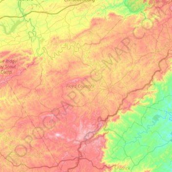
Name: Floyd County topographic map, elevation, terrain.
Location: Floyd County, Virginia, United States (36.70872 -80.63398 37.12336 -80.10441)
Average elevation: 2,320 ft
Minimum elevation: 1,001 ft
Maximum elevation: 3,875 ft
Virginia trails, hiking, mountain biking, running and outdoor activities
Other topographic maps
Click on a map to view its topography, its elevation and its terrain.
Virginia Beach
United States > Virginia > Virginia Beach
According to the United States Census Bureau, the city has a total area of 497 square miles (1,290 km2), of which 249 square miles (640 km2) is land and 248 square miles (640 km2) (49.9%) is water. It is the largest city in Virginia by total area and third-largest city land area. The average elevation is 12…
Average elevation: 7 ft
Blue Ridge Mountains
United States > Virginia > Botetourt County
Although the term "Blue Ridge" is sometimes applied exclusively to the eastern edge or front range of the Appalachian Mountains, the geological definition of the Blue Ridge province extends westward to the Ridge and Valley area, encompassing the Great Smoky Mountains, the Great Balsams, the Roans, the Blacks,…
Average elevation: 1,509 ft
Prince William Forest Park
United States > Virginia > Prince William County > Triangle
Average elevation: 266 ft
Eggleston
United States > Virginia > Giles County
It lies at an elevation of 1,821 feet.
Average elevation: 1,877 ft
Loudoun Valley Estates
United States > Virginia > Loudoun County
The land around Loudoun Valley Estates is gently rolling. The average elevation is 289 feet (88 m). The population density is about 500 people per square kilometer.
Average elevation: 299 ft
Mount Rogers
United States > Virginia > Smyth County
Mount Rogers is the highest natural point in Virginia, United States, with a summit elevation of 5,729 ft (1,746 m) above mean sea level. The summit straddles the border of Grayson and Smyth Counties, Virginia, about 6.45 mi (10.38 km) WSW of Troutdale, Virginia. Most of the mountain is contained within the…
Average elevation: 4,944 ft