
Make a donation
Gear up for your next adventure:
As an Amazon Associate, this site earns from qualifying purchases at no extra cost to you.
Connecticut River topographic map
Click on the map to display elevation.
Make a donation
Gear up for your next adventure:
As an Amazon Associate, this site earns from qualifying purchases at no extra cost to you.
Connecticut River
The Connecticut River rises from Fourth Connecticut Lake, a small pond 300 yards (270 m) south of the Canada–United States border in the town of Pittsburg, New Hampshire, at an elevation of 2,670 feet (810 m) above sea level. It flows through the remaining Connecticut Lakes and Lake Francis for 14 miles (23 km), all within the town of Pittsburg, and then widens as it delineates 255 miles (410 km) of the border between New Hampshire and Vermont. The river drops more than 2,480 feet (760 m) in elevation as it winds south to the border of Massachusetts where it sits 190 feet (58 m) above sea level.
Make a donation
Gear up for your next adventure:
As an Amazon Associate, this site earns from qualifying purchases at no extra cost to you.
About this map
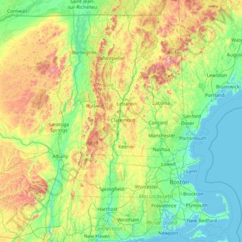
Name: Connecticut River topographic map, elevation, terrain.
Location: Connecticut River, United States (41.27156 -72.66540 45.24704 -71.16863)
Average elevation: 866 ft
Minimum elevation: -16 ft
Maximum elevation: 6,211 ft
United States trails, hiking, mountain biking, running and outdoor activities
Make a donation
Gear up for your next adventure:
As an Amazon Associate, this site earns from qualifying purchases at no extra cost to you.
Other topographic maps
Click on a map to view its topography, its elevation and its terrain.
Tucson
United States > Arizona > Pima County > Tucson
The city's elevation is 2,643 ft (806 m) above sea level (as measured at the Tucson International Airport). Tucson is on an alluvial plain in the Sonoran Desert, surrounded by five minor ranges of mountains: the Santa Catalina Mountains and the Tortolita Mountains to the north, the Santa Rita Mountains to the…
Average elevation: 2,743 ft
Baltimore
Baltimore exhibits a diverse topography that plays a significant role in its character and development. Situated along the Patapsco River, which flows into the Chesapeake Bay, the city is positioned on the fall line that separates the Piedmont Plateau to the west from the Atlantic Coastal Plain to the east.…
Average elevation: 213 ft
Atlanta
United States > Georgia > Fulton County
Atlanta (/ætˈlæntə/ at-LAN-tə) is the capital and most populous city of the U.S. state of Georgia. It is the seat of Fulton County, the most populous county in Georgia. With a population of 498,715 living within the city limits, it is the eighth most populous city in the Southeast and 38th most populous…
Average elevation: 935 ft
Flagstaff
United States > Arizona > Coconino County
Flagstaff, located in Coconino County, Arizona, is characterized by its diverse topography, primarily shaped by its high elevation and volcanic activity. Sitting at around 7,000 feet (approximately 2,130 meters), the city is surrounded by the expansive Coconino National Forest, which features a blend of…
Average elevation: 7,139 ft
Make a donation
Gear up for your next adventure:
As an Amazon Associate, this site earns from qualifying purchases at no extra cost to you.
La Jolla
United States > California > San Diego County > San Diego > La Jolla
Average elevation: 121 ft
Make a donation
Gear up for your next adventure:
As an Amazon Associate, this site earns from qualifying purchases at no extra cost to you.
Placerville
United States > California > Placerville
The region east of Placerville, popularly known as Apple Hill and Pleasant Valley, is becoming a center for wine production. The wine region is officially designated as the El Dorado AVA. The largest wineries in the area are Boeger, Lava Cap and Madrona, but most of the 30 plus wineries surrounding Placerville…
Average elevation: 1,926 ft
Fairhope
United States > Alabama > Baldwin County > Fairhope
According to the U.S. Census Bureau, the city has a total area of 12.0 square miles (31.1 km2), of which 0.019 square mile (0.05 km2), or 0.16%, is water. Its elevation ranges from sea level at the bay to 122 feet (37 m) in the city center.
Average elevation: 115 ft
Make a donation
Gear up for your next adventure:
As an Amazon Associate, this site earns from qualifying purchases at no extra cost to you.
Thousand Oaks
United States > California > Ventura County > Thousand Oaks
The northern parts consist of mountainous terrain in the Simi Hills, Conejo Mountains and Mount Clef Ridge. Narrow canyons such as Hill Canyon cut through the steeper mountainous areas. Conejo Mountain and Conejo Grade are found in westernmost Newbury Park, while the southernmost parts of Thousand Oaks are…
Average elevation: 994 ft
Denver
Denver is in the western United States, in the South Platte River Valley on the western edge of the High Plains just east of the Front Range of the Rocky Mountains. Its downtown district is immediately east of the confluence of Cherry Creek and the South Platte River, about 12 miles (19 kilometres) east of the…
Average elevation: 5,459 ft
Make a donation
Gear up for your next adventure:
As an Amazon Associate, this site earns from qualifying purchases at no extra cost to you.
Largo
United States > Florida > Pinellas County > Largo
In 2010, Largo's total area was 18.6 square miles (48.1 km2), of which 17.6 square miles (45.6 km2) was land and 0.97 square miles (2.5 km2), or 5.22%, was water. As of 2004, there were 651 acres (2.6 km2) of park lands. The city's lowest elevation is sea level. At its highest, the city's elevation is about 69…
Average elevation: 16 ft
Menifee
United States > California > Riverside County
Menifee is a city in Riverside County, California, United States, and part of the Los Angeles Combined Statistical Area. The city is centrally located in Southern California in the Menifee Valley. It is almost 15 miles (24 km) north of Temecula and just north of Murrieta. Menifee is roughly 46 square miles…
Average elevation: 1,496 ft
Make a donation
Gear up for your next adventure:
As an Amazon Associate, this site earns from qualifying purchases at no extra cost to you.
Idyllwild-Pine Cove
United States > California > Riverside County
"Mile-high Idyllwild" is a mountain resort about one-mile (1,600 m) in altitude. Idyllwild is flanked by two large rock formations, Tahquitz Peak and Suicide Rock (also known as Lily Rock), which are famous in Southern California rock-climbing circles. It offers no skiing, so "the Hill" has been minimally…
Average elevation: 5,728 ft
Haverhill
United States > Massachusetts > Essex County > Haverhill
According to the United States Census Bureau, the city has a total area of 35.6 square miles (92.3 km2), of which 33.0 square miles (85.4 km2) is land and 2.7 square miles (6.9 km2), or 7.47%, is water. The city ranks 60th in the Commonwealth in terms of land area, and is the largest city or town in Essex…
Average elevation: 148 ft
Make a donation
Gear up for your next adventure:
As an Amazon Associate, this site earns from qualifying purchases at no extra cost to you.
Boise
United States > Idaho > Ada County
Boise (locally /ˈbɔɪsi/ BOY-see) is the capital and most populous city of the U.S. state of Idaho and is the county seat of Ada County. As of the 2020 census, there were 235,684 people residing in the city. On the Boise River in southwestern Idaho, it is 41 miles (66 km) east of the Oregon border and 110…
Average elevation: 3,412 ft
Troy
United States > New York > Rensselaer County
The western edge of the city is flat along the river, and then steeply slopes to higher terrain to the east. The average elevation is 50 feet, with the highest elevation being 500 feet in the eastern part of the city. The city is longer than it is wide, with the southern part wider than the northern section of…
Average elevation: 449 ft
Fairbanks
United States > Alaska > Fairbanks North Star
Fairbanks is situated within the central Tanana Valley, characterized by a diverse and dynamic topography. The city straddles the Chena River, which flows southwest into the larger Tanana River, defining Fairbanks' southern border. To the north, a gradual incline leads into a chain of hills that ascend toward…
Average elevation: 479 ft
Make a donation
Gear up for your next adventure:
As an Amazon Associate, this site earns from qualifying purchases at no extra cost to you.
Air Force Academy
United States > Colorado > El Paso County > Colorado Springs
The campus of the academy covers 18,455 acres (29 sq mi; 75 km2) on the east side of the Rampart Range of the Rocky Mountains, just north of Colorado Springs. Its elevation is normally given as 7,258 feet (2,212 m) above sea level, which is at the cadet area. The academy was designed by Skidmore, Owings and…
Average elevation: 7,080 ft
Diamondhead
United States > Mississippi > Hancock County
Much of the land that became Diamondhead had been purchased by Walter Gex, Sr., in 1937 from the Gulf State Paper Company and the Easy Opener Bag Company. Additional land was purchased by Gex, bringing his acquisition to nearly 5,000 acres (2,000 ha). In the late 1960s, D.E.A.R., Inc., later known as the…
Average elevation: 10 ft
Fraser
United States > Colorado > Grand County
Fraser is located in southeastern Grand County at 39°56′39″N 105°48′48″W / 39.94417°N 105.81333°W / 39.94417; -105.81333 (39.944158, -105.813355), at an elevation of 8,574 feet (2,613 m) above sea level. It is bordered to the south by the town of Winter Park and to the north by…
Average elevation: 8,845 ft
Make a donation
Gear up for your next adventure:
As an Amazon Associate, this site earns from qualifying purchases at no extra cost to you.
Florida Keys
United States > Florida > Monroe County
The Florida Keys, an archipelago extending about 120 miles from the southeastern tip of Florida, feature a unique topography characterized by low-lying coral islands and a series of intricate waterways. Most islands are less than 5 feet above sea level, contributing to their vulnerability to storm surges and…
Average elevation: 0 ft
Lancaster
United States > California > Lancaster
According to the United States Census Bureau, the city has a total area of 94.5 square miles (245 km2), of which 94.3 square miles (244 km2) is land and 0.3 square miles (0.78 km2) (0.29%) is water. Lancaster's elevation is 2,350 feet (720 m) above sea level on a high, flat valley surrounded by pristine…
Average elevation: 2,582 ft
Virginia Beach
United States > Virginia > Virginia Beach
Virginia Beach, Virginia, located in the coastal region of the United States, features a predominantly flat terrain characterized by its proximity to the Atlantic Ocean. The elevation is remarkably low, averaging about 10 feet (3 meters) above sea level, which contributes to the area's susceptibility to…
Average elevation: 7 ft
Indianapolis
United States > Indiana > Indianapolis
Indianapolis is within the Tipton Till Plain, a flat to gently sloping terrain underlain by glacial deposits known as till. The lowest point in the city is about 650 feet (198 m) above mean sea level, with the highest natural elevation at about 900 feet (274 m) above sea level. Few hills or short ridges, known…
Average elevation: 791 ft
Make a donation
Gear up for your next adventure:
As an Amazon Associate, this site earns from qualifying purchases at no extra cost to you.
Pinetop-Lakeside
United States > Arizona > Navajo County
Pinetop-Lakeside is nestled in the stunning White Mountains of northeastern Arizona, characterized by a varied topography that significantly influences its natural beauty and recreational opportunities. The terrain features elevations averaging around 6,795 feet, with rugged mountain landscapes interspersed…
Average elevation: 6,847 ft
Augusta
United States > Georgia > Augusta
As with the rest of the state, Augusta has a humid subtropical climate (Köppen Cfa), with short, mild winters, very hot, humid summers, and a wide diurnal temperature variation throughout much of the year, despite its low elevation and moisture. The monthly daily average temperature ranges from 45.4 °F (7.4…
Average elevation: 295 ft
Make a donation
Gear up for your next adventure:
As an Amazon Associate, this site earns from qualifying purchases at no extra cost to you.
Crested Butte
United States > Colorado > Gunnison County
At the 2020 United States Census, the town had a total area of 535 acres (2.166 km2), all of it land. Crested Butte lies at an elevation of 8,885 feet (2,708 m) above sea level.
Average elevation: 9,180 ft
Hot Springs National Park
United States > Arkansas > Garland County > Hot Springs
The National Park Service exercises no control or supervision over any matters connected with the city. The city starts on the other side of Central Avenue from Bathhouse Row. Its development has extended beyond the narrow valley in which the springs are located, spreading out over the open plain to the south…
Average elevation: 745 ft
Nederland
United States > Colorado > Boulder County
In 1873 the Caribou Mine, at an elevation of roughly 10,000 feet (3,000 m) and 6 miles (10 km) northwest of the town, was sold to the Mining Company Nederland from the Netherlands. The high elevation meant fierce winds and deep winter snow, so the new owners of the mine decided that it was beneficial to bring…
Average elevation: 8,458 ft
Make a donation
Gear up for your next adventure:
As an Amazon Associate, this site earns from qualifying purchases at no extra cost to you.
Yucca Valley
United States > California > San Bernardino County
Yucca Valley lies in the middle of the Morongo Basin at a base elevation of 3,300 feet. Joshua Tree National Park is adjacent to its southern border.
Average elevation: 3,629 ft
Dallas
United States > Texas > Dallas County
Dallas and its surrounding area are mostly flat. The city lies at elevations ranging from 450 to 550 feet (137 to 168 m) above sea level. The western edge of the Austin Chalk Formation, a limestone escarpment (also known as the "White Rock Escarpment"), rises 230 feet (70 m) and runs roughly north–south…
Average elevation: 518 ft
Madison
United States > Wisconsin > Dane County
The city is sometimes described as The City of Four Lakes, comprising the four successive lakes of the Yahara River: Lake Mendota ("Fourth Lake"), Lake Monona ("Third Lake"), Lake Waubesa ("Second Lake") and Lake Kegonsa ("First Lake"), although Waubesa and Kegonsa are not actually in Madison, but just south…
Average elevation: 948 ft
Make a donation
Gear up for your next adventure:
As an Amazon Associate, this site earns from qualifying purchases at no extra cost to you.
Pollock Pines
United States > California > El Dorado County
Pollock Pines is a census-designated place (CDP) in El Dorado County, California, United States. It is part of the Sacramento–Arden-Arcade–Roseville Metropolitan Statistical Area. Pollock Pines lies at an elevation of 3,980 feet (1,210 m) in the Sierra Nevada. The population was 6,871 at the 2010 census,…
Average elevation: 3,681 ft
Make a donation
Gear up for your next adventure:
As an Amazon Associate, this site earns from qualifying purchases at no extra cost to you.
Twentynine Palms
United States > California > Twentynine Palms
According to the United States Census Bureau, the city has a total area of 59.1 square miles (153 km2), all land. The city is at an elevation of 1,988 feet (606 m). The Marine Corps Air Ground Combat Center Twentynine Palms is located there.
Average elevation: 2,264 ft
Make a donation
Gear up for your next adventure:
As an Amazon Associate, this site earns from qualifying purchases at no extra cost to you.
Snoqualmie Pass
United States > Washington > King County
Due to its elevation, Snoqualmie Pass experiences significantly lower temperatures than Seattle, and receives much more precipitation, much of it being snow. Snoqualmie Pass has a humid continental climate (Koppen: Dsb bordering Csb) with cold, very wet and snowy winters, and mild to warm, relatively dry…
Average elevation: 3,438 ft
Mount Rushmore
Mount Rushmore National Memorial is centered on a colossal sculpture carved into the granite face of Mount Rushmore (Lakota Tȟuŋkášila Šákpe, or Six Grandfathers) in the Black Hills in Keystone, South Dakota. Sculptor Gutzon Borglum created the sculpture's design and oversaw the project's execution from…
Average elevation: 5,125 ft
Hudson
United States > Florida > Hudson
Hudson features a predominantly flat and low-lying topography typical of the region, with an average elevation of approximately 16 feet above sea level. This terrain is interspersed with various wetlands and small lakes, creating a rich ecosystem that supports diverse wildlife. The area also includes a few…
Average elevation: 16 ft
Elizabethton
United States > Tennessee > Carter County > Elizabethton > Elizabethton
The elevation at Elizabethton Municipal Airport is 1,593 feet (486 m) ASL (the highest point of elevation in Carter County is at Roan Mountain with an elevation of 6,285 feet (1,916 m) ASL), and the airport is located on the eastern side of the city along State Highway 91 Stoney Creek Exit. Elizabethton is…
Average elevation: 1,729 ft
Make a donation
Gear up for your next adventure:
As an Amazon Associate, this site earns from qualifying purchases at no extra cost to you.
San Diego
United States > California > San Diego County > San Diego
The climate in San Diego, like most of Southern California, often varies significantly over short geographical distances, resulting in microclimates. In San Diego, this is mostly because of the city's topography (the Bay, and the numerous hills, mountains, and canyons). Frequently, particularly during the "May…
Average elevation: 187 ft
Hemet
United States > California > Hemet
Dedicated to James Simpson, Hemet City Council 1947–48, and mayor 1950 to 1966. Simpson Park is a wilderness park located in the Santa Rosa Hills southeast of Hemet with sheltered picnic area and tables, barbecues, restrooms, and hiking trails. At an elevation of 2,500 feet (760 m), it provides an expansive…
Average elevation: 1,667 ft
Silverton
United States > Colorado > San Juan County
According to the United States Census Bureau, the town has a total area of 0.8 square miles (2.1 km2), all of it land. Silverton is one of the highest towns in the United States, at 9,318 feet (2,840 m) above sea level. The town is located in San Juan County, the highest county in the United States, with a…
Average elevation: 9,813 ft
Make a donation
Gear up for your next adventure:
As an Amazon Associate, this site earns from qualifying purchases at no extra cost to you.
East Hampton
United States > New York > Suffolk County > East Hampton > Village of East Hampton
Average elevation: 39 ft
Susanville
United States > California > Lassen County
Susanville (formerly known as Rooptown) is a town in and is the county seat of Lassen County, California, United States. Susanville is located on the Susan River in the southern part of the county, at an elevation of 4,186 feet (1,276 m). Its population is 16,728 as of the 2020 census, down from 17,947 from…
Average elevation: 4,413 ft
Make a donation
Gear up for your next adventure:
As an Amazon Associate, this site earns from qualifying purchases at no extra cost to you.
Watertown
United States > New York > Jefferson County
Watertown is around 60 miles (97 kilometers) northwest of Syracuse, 20 miles (32 kilometers) south of the Thousand Islands and 328 miles (530 kilometers) northwest of New York City. According to the United States Census Bureau, the city has a total area of 9.3 square miles (24 km2), of which 9.0 square miles…
Average elevation: 643 ft
Aberdeen
United States > Washington > Grays Harbor County > Aberdeen
Aberdeen is at the eastern end of Grays Harbor, near the mouth of the Chehalis River and southwest of the Olympic Mountains. Grays Harbor is notable as the northernmost ria on North America's Pacific Coast because it has remained free of glaciers throughout the Quaternary due to unfavorable topography and warm…
Average elevation: 217 ft
Newbury Park
United States > California > Ventura County > Thousand Oaks
Newbury Park can be described as a town,[6] community,[94] or section[9] mostly within the Thousand Oaks city limits in addition to rural areas west of Thousand Oaks. Newbury Park is bordered by Lynn Road in the east and the Conejo Grade on the west. It borders the Santa Monica Mountains in the south, while…
Average elevation: 860 ft
Make a donation
Gear up for your next adventure:
As an Amazon Associate, this site earns from qualifying purchases at no extra cost to you.
Sparta
United States > New Jersey > Sussex County > Sparta Township > Sparta
Average elevation: 906 ft
San Pedro Hill
United States > California > Los Angeles County > Rancho Palos Verdes
Average elevation: 935 ft
Sebastopol
United States > California > Sonoma County
Sebastopol's elevation is 65 to 250 feet (20 to 76 meters) above sea level. Its downtown is at the intersection of State Route 12 and State Route 116 (Gravenstein Highway), approximately 9 mi (14 km) west of U.S. Route 101.
Average elevation: 226 ft
Make a donation
Gear up for your next adventure:
As an Amazon Associate, this site earns from qualifying purchases at no extra cost to you.
Tombstone
United States > Arizona > Tombstone > Tombstone
The Tombstone District located at 31°42′57″N 110°3′53″W / 31.71583°N 110.06472°W / 31.71583; -110.06472 (31.715940, −110.064827) sits atop a mesa (elevation 4,539 feet (1,383 m)) in the San Pedro River valley between the Huachuca Mountains and Whetstone Mountains to the west, and the…
Average elevation: 4,469 ft
Saratoga Springs
United States > New York > Saratoga County > Saratoga Springs
Average elevation: 528 ft
Make a donation
Gear up for your next adventure:
As an Amazon Associate, this site earns from qualifying purchases at no extra cost to you.
Ketchikan
United States > Alaska > Ketchikan
Due to its steep and forested terrain, Ketchikan is long and narrow with much of the built-up area being located along, or no more than a few city blocks from, the waterfront. Elevations of inhabited areas range from just above sea level to about 300 feet (91 m). Deer Mountain, a 3,001-foot (915 m) peak, rises…
Average elevation: 489 ft
Make a donation
Gear up for your next adventure:
As an Amazon Associate, this site earns from qualifying purchases at no extra cost to you.
Estes Park
United States > Colorado > Larimer County
Estes Park sits at an elevation of 7,522 feet (2,293 m) on the front range of the Rocky Mountains at the eastern entrance of the Rocky Mountain National Park. Its location is 40°22′22″N 105°31′09″W / 40.372856°N 105.519136°W / 40.372856; -105.519136. Its north, south and east extremities…
Average elevation: 7,904 ft
Make a donation
Gear up for your next adventure:
As an Amazon Associate, this site earns from qualifying purchases at no extra cost to you.
Camp Pendleton
United States > California > San Diego County > Marine Corps Base Camp Pendleton
Average elevation: 79 ft
Horseshoe Bay
United States > Texas > Llano County > Horseshoe Bay > Horseshoe Bay
Average elevation: 938 ft
Seligman
United States > Arizona > Yavapai County > Seligman
Seligman is located at 35°19′42″N 112°52′27″W / 35.32833°N 112.87417°W / 35.32833; -112.87417 (35.328199, −112.874303), at 5,240 feet (1,600 m) in elevation, alongside the Big Chino Wash, in a northern section of Chino Valley. The wash is a major tributary of the Verde River. Seligman is…
Average elevation: 5,305 ft
Make a donation
Gear up for your next adventure:
As an Amazon Associate, this site earns from qualifying purchases at no extra cost to you.
Hampton Beach
United States > New Hampshire > Rockingham County > Hampton Beach
Average elevation: 7 ft
Make a donation
Gear up for your next adventure:
As an Amazon Associate, this site earns from qualifying purchases at no extra cost to you.
Erie Canal
United States > New York > Erie County > City of Tonawanda
The construction of the Erie Canal was a landmark civil engineering achievement in the early history of the United States. When built, the 363-mile (584 km) canal was the second-longest in the world (after the Grand Canal in China). Initially 40 feet (12 m) wide and 4 feet (1.2 m) deep, the canal was expanded…
Average elevation: 581 ft
Fort Bragg
United States > California > Mendocino County
Fort Bragg, officially the City of Fort Bragg, is a city along the Pacific Coast of California along Shoreline Highway in Mendocino County. The city is 24 miles (39 km) west of Willits, at an elevation of 85 feet (26 m). Its population was 6,983 at the 2020 census.
Average elevation: 26 ft
Make a donation
Gear up for your next adventure:
As an Amazon Associate, this site earns from qualifying purchases at no extra cost to you.