
Make a donation
Gear up for your next adventure:
As an Amazon Associate, this site earns from qualifying purchases at no extra cost to you.
Hinds County topographic map
Click on the map to display elevation.
Make a donation
Gear up for your next adventure:
As an Amazon Associate, this site earns from qualifying purchases at no extra cost to you.
About this map
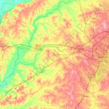
Name: Hinds County topographic map, elevation, terrain.
Location: Hinds County, Mississippi, United States (32.04836 -90.72863 32.57350 -90.06455)
Average elevation: 256 ft
Minimum elevation: 66 ft
Maximum elevation: 469 ft
Mississippi trails, hiking, mountain biking, running and outdoor activities
Make a donation
Gear up for your next adventure:
As an Amazon Associate, this site earns from qualifying purchases at no extra cost to you.
Other topographic maps
Click on a map to view its topography, its elevation and its terrain.
Diamondhead
United States > Mississippi > Hancock County
Much of the land that became Diamondhead had been purchased by Walter Gex, Sr., in 1937 from the Gulf State Paper Company and the Easy Opener Bag Company. Additional land was purchased by Gex, bringing his acquisition to nearly 5,000 acres (2,000 ha). In the late 1960s, D.E.A.R., Inc., later known as the…
Average elevation: 10 ft
Poplar Springs
United States > Mississippi > Lauderdale County > Meridian > Houston
Average elevation: 423 ft
Make a donation
Gear up for your next adventure:
As an Amazon Associate, this site earns from qualifying purchases at no extra cost to you.
Brown Lake
United States > Mississippi > Warren County > Vicksburg > Porters Chapel
Average elevation: 167 ft
Mississippi
Mississippi is entirely composed of lowlands, the highest point being Woodall Mountain, at 807 ft (246 m) above sea level, in the northeastern part of the state. The lowest point is sea level at the Gulf Coast. The state's mean elevation is 300 ft (91 m) above sea level.
Average elevation: 285 ft
Make a donation
Gear up for your next adventure:
As an Amazon Associate, this site earns from qualifying purchases at no extra cost to you.
Noxubee National Wildlife Refuge
United States > Mississippi > Noxubee County
Average elevation: 243 ft
Lake Catherine
United States > Mississippi > Hinds County > Jackson > Lost Lake
Average elevation: 328 ft
Make a donation
Gear up for your next adventure:
As an Amazon Associate, this site earns from qualifying purchases at no extra cost to you.
Make a donation
Gear up for your next adventure:
As an Amazon Associate, this site earns from qualifying purchases at no extra cost to you.
Make a donation
Gear up for your next adventure:
As an Amazon Associate, this site earns from qualifying purchases at no extra cost to you.
Make a donation
Gear up for your next adventure:
As an Amazon Associate, this site earns from qualifying purchases at no extra cost to you.
Make a donation
Gear up for your next adventure:
As an Amazon Associate, this site earns from qualifying purchases at no extra cost to you.
Make a donation
Gear up for your next adventure:
As an Amazon Associate, this site earns from qualifying purchases at no extra cost to you.
Make a donation
Gear up for your next adventure:
As an Amazon Associate, this site earns from qualifying purchases at no extra cost to you.
Make a donation
Gear up for your next adventure:
As an Amazon Associate, this site earns from qualifying purchases at no extra cost to you.
Make a donation
Gear up for your next adventure:
As an Amazon Associate, this site earns from qualifying purchases at no extra cost to you.
Bell-Sandifer Leisure Park
United States > Mississippi > Forrest County > Hattiesburg
Average elevation: 161 ft
Make a donation
Gear up for your next adventure:
As an Amazon Associate, this site earns from qualifying purchases at no extra cost to you.
Diamondhead
Much of the land that became Diamondhead had been purchased by Walter Gex Sr., in 1937 from the Gulf State Paper Company and the Easy Opener Bag Company. Additional land was purchased by Gex, bringing his acquisition to nearly 5,000 acres (2,000 ha). In the late 1960s, D.E.A.R., Inc., later known as the…
Average elevation: 13 ft
Make a donation
Gear up for your next adventure:
As an Amazon Associate, this site earns from qualifying purchases at no extra cost to you.
Make a donation
Gear up for your next adventure:
As an Amazon Associate, this site earns from qualifying purchases at no extra cost to you.
Make a donation
Gear up for your next adventure:
As an Amazon Associate, this site earns from qualifying purchases at no extra cost to you.
Make a donation
Gear up for your next adventure:
As an Amazon Associate, this site earns from qualifying purchases at no extra cost to you.
Make a donation
Gear up for your next adventure:
As an Amazon Associate, this site earns from qualifying purchases at no extra cost to you.
Kosciusko
United States > Mississippi > Attala County > Kosciusko > Kosciusko
Average elevation: 433 ft
Make a donation
Gear up for your next adventure:
As an Amazon Associate, this site earns from qualifying purchases at no extra cost to you.
Grand Bay Natural Wildlife Refuge
United States > Mississippi > Jackson County > Moss Point
Average elevation: 10 ft
Marine Education Center
United States > Mississippi > Jackson County > Ocean Springs
Average elevation: 13 ft
Make a donation
Gear up for your next adventure:
As an Amazon Associate, this site earns from qualifying purchases at no extra cost to you.
Make a donation
Gear up for your next adventure:
As an Amazon Associate, this site earns from qualifying purchases at no extra cost to you.
Make a donation
Gear up for your next adventure:
As an Amazon Associate, this site earns from qualifying purchases at no extra cost to you.
Meridian
United States > Mississippi > Lauderdale County > Meridian > Meridian
Average elevation: 400 ft
Traceland North
United States > Mississippi > Madison County > Madison > Traceland North
Average elevation: 335 ft
Make a donation
Gear up for your next adventure:
As an Amazon Associate, this site earns from qualifying purchases at no extra cost to you.
Ocean Springs
United States > Mississippi > Jackson County > Ocean Springs > Ocean Springs
Average elevation: 13 ft
Make a donation
Gear up for your next adventure:
As an Amazon Associate, this site earns from qualifying purchases at no extra cost to you.
Make a donation
Gear up for your next adventure:
As an Amazon Associate, this site earns from qualifying purchases at no extra cost to you.
White Harbor
United States > Mississippi > Harrison County > Pass Christian > White Harbor
Average elevation: 16 ft
Make a donation
Gear up for your next adventure:
As an Amazon Associate, this site earns from qualifying purchases at no extra cost to you.