
沙坡头区 topographic map
Interactive map
Click on the map to display elevation.
About this map
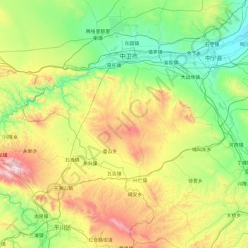
Name: 沙坡头区 topographic map, elevation, terrain.
Location: 沙坡头区, 中卫市, 宁夏回族自治区, 755000, 中国 (36.66402 104.28420 37.71560 105.68838)
Average elevation: 5,282 ft
Minimum elevation: 3,819 ft
Maximum elevation: 9,724 ft
Other topographic maps
Click on a map to view its topography, its elevation and its terrain.