
Make a donation
Gear up for your next adventure:
As an Amazon Associate, this site earns from qualifying purchases at no extra cost to you.
Iran topographic map
Click on the map to display elevation.
Make a donation
Gear up for your next adventure:
As an Amazon Associate, this site earns from qualifying purchases at no extra cost to you.
Iran
Iran's topography is diverse and dominated by rugged mountain ranges, which define much of its landscape. To the west, the Zagros Mountains stretch from the northwest to the southeast, with many peaks surpassing 10,000 feet (3,048 meters) in elevation. These mountains form a rugged barrier between Iran's central plateau and the more fertile regions of the southwest. Further to the north, the Alborz Mountains flank the Caspian Sea, where Iran's highest peak, Mount Damavand (18,402 feet, 5,609 meters), is located. This mountainous terrain gives way to vast basins and desert plains, particularly in the central and eastern regions of the country. The Dasht-e Kavir and Dasht-e Lut, two prominent salt deserts, cover large areas and experience extreme temperatures and minimal rainfall. In contrast, the coastal regions along the Caspian Sea and Persian Gulf feature small, discontinuous plains. These varied landscapes create a dramatic and dynamic environment, affecting everything from climate to human settlement.
Make a donation
Gear up for your next adventure:
As an Amazon Associate, this site earns from qualifying purchases at no extra cost to you.
About this map
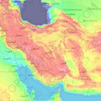
Name: Iran topographic map, elevation, terrain.
Location: Iran (24.83531 44.03189 39.78246 63.33327)
Average elevation: 2,579 ft
Minimum elevation: -95 ft
Maximum elevation: 15,771 ft
Make a donation
Gear up for your next adventure:
As an Amazon Associate, this site earns from qualifying purchases at no extra cost to you.
Other topographic maps
Click on a map to view its topography, its elevation and its terrain.
San Francisco Bay Area
United States > California > San Francisco
The San Francisco Bay Area is characterized by a diverse and dynamic topography shaped by geological processes over millions of years. This region features a combination of coastal plains, steep hills, and rugged mountains, all influenced by the tectonic activity associated with the nearby San Andreas Fault…
Average elevation: 371 ft
Flagstaff
United States > Arizona > Coconino County
Flagstaff, located in Coconino County, Arizona, is characterized by its diverse topography, primarily shaped by its high elevation and volcanic activity. Sitting at around 7,000 feet (approximately 2,130 meters), the city is surrounded by the expansive Coconino National Forest, which features a blend of…
Average elevation: 7,139 ft
City of London
United Kingdom > England > City of London > City of London
The elevation of the City ranges from sea level at the Thames to 21.6 metres (71 ft) at the junction of High Holborn and Chancery Lane. Two small but notable hills are within the historic core, Ludgate Hill to the west and Cornhill to the east. Between them ran the Walbrook, one of the many "lost" rivers or…
Average elevation: 138 ft
Make a donation
Gear up for your next adventure:
As an Amazon Associate, this site earns from qualifying purchases at no extra cost to you.
Austria
According to the Köppen Climate Classification Austria has the following climate types: Oceanic (Cfb), Cool/Warm-summer humid continental (Dfb), Subarctic/Subalpine (Dfc), Tundra/Alpine (ET), and Ice-Cap (EF). It is important to note though that Austria may experience very cold, severe winters, but most of…
Average elevation: 1,096 ft
Himalayas
Nepal > Koshi Province > Solukhumbu
The Himalayas present a dramatic and varied topography characterized by towering peaks, deep valleys, and extensive glaciers. This majestic mountain range features some of the highest elevations on Earth, including Mount Everest, which rises to 29,035 feet. The terrain is marked by steep, jagged ridges and…
Average elevation: 24,787 ft
Make a donation
Gear up for your next adventure:
As an Amazon Associate, this site earns from qualifying purchases at no extra cost to you.
El Dorado Hills
United States > California > El Dorado County > Cameron Park
El Dorado Hills (EDH), as defined by the 2010 census-designated place (CDP), is at the western border of El Dorado County, between the City of Folsom and the unincorporated community of Cameron Park. The northern limits of the CDP are Folsom Lake and the South Fork of the American River, where river rafters…
Average elevation: 833 ft
Denali
United States > Alaska > Denali Borough
Denali (/dəˈnɑːli/ də-NAH-lee), federally designated as Mount McKinley, is the highest mountain peak in North America, with a summit elevation of 20,310 feet (6,190 m) above sea level. It is the tallest mountain in the world from base to peak on land, measuring 18,000 ft (5,500 m). With a topographic…
Average elevation: 18,196 ft
Make a donation
Gear up for your next adventure:
As an Amazon Associate, this site earns from qualifying purchases at no extra cost to you.
Evergreen
United States > Colorado > Jefferson County
Evergreen sits at an elevation of 7,220 feet (2,200 m) in the Rocky Mountains, 19 miles west of Denver, Colorado. Its addresses are oriented according to the Street_system_of_Denver.
Average elevation: 7,575 ft
Fairbanks
United States > Alaska > Fairbanks North Star
Fairbanks is situated within the central Tanana Valley, characterized by a diverse and dynamic topography. The city straddles the Chena River, which flows southwest into the larger Tanana River, defining Fairbanks' southern border. To the north, a gradual incline leads into a chain of hills that ascend toward…
Average elevation: 479 ft
Gulf of Mexico
Average elevation: 66 ft
Make a donation
Gear up for your next adventure:
As an Amazon Associate, this site earns from qualifying purchases at no extra cost to you.
Europe
Europe's topography is characterized by a striking contrast between its rugged southern mountains and the expansive plains of the north. The continent is often described as a "peninsula of peninsulas," featuring major peninsulas like the Iberian, Italian, and Balkan, each with unique geological features. In…
Average elevation: 732 ft
Baltimore
Baltimore exhibits a diverse topography that plays a significant role in its character and development. Situated along the Patapsco River, which flows into the Chesapeake Bay, the city is positioned on the fall line that separates the Piedmont Plateau to the west from the Atlantic Coastal Plain to the east.…
Average elevation: 213 ft
Elizabethton
United States > Tennessee > Carter County > Elizabethton > Elizabethton
The elevation at Elizabethton Municipal Airport is 1,593 feet (486 m) ASL (the highest point of elevation in Carter County is at Roan Mountain with an elevation of 6,285 feet (1,916 m) ASL), and the airport is located on the eastern side of the city along State Highway 91 Stoney Creek Exit. Elizabethton is…
Average elevation: 1,729 ft
Make a donation
Gear up for your next adventure:
As an Amazon Associate, this site earns from qualifying purchases at no extra cost to you.
Port Charlotte
United States > Florida > Charlotte County
Port Charlotte is characterized by a predominantly flat and low-lying terrain, typical of Florida’s coastal landscape. The area features a network of waterways, including the Peace River and Charlotte Harbor, which provide ample opportunities for recreational activities like boating and fishing. Elevations…
Average elevation: 13 ft
Atlanta
United States > Georgia > Fulton County
Atlanta occupies a high, rolling part of the Georgia Piedmont, a physiographic region described as a landscape of low hills and narrow valleys between the Blue Ridge Mountains and the Upper Coastal Plain. Around downtown and Fulton County, the terrain is gently dissected rather than flat, with broad urban…
Average elevation: 935 ft
Make a donation
Gear up for your next adventure:
As an Amazon Associate, this site earns from qualifying purchases at no extra cost to you.
Estes Park
United States > Colorado > Larimer County
Estes Park sits at an elevation of 7,522 feet (2,293 m) on the front range of the Rocky Mountains at the eastern entrance of the Rocky Mountain National Park. Its location is 40°22′22″N 105°31′09″W / 40.372856°N 105.519136°W / 40.372856; -105.519136. Its north, south and east extremities…
Average elevation: 7,904 ft
Santa Cruz Mountains
United States > California > Santa Clara County
The Santa Cruz Mountains are a region of great biological diversity, encompassing cool, moist coastal ecosystems as well as warm, dry chaparral. Much of the area in the Santa Cruz mountains is considered temperate rainforest. In valleys and moist ocean-facing slopes some of the southernmost coast redwoods…
Average elevation: 755 ft
Anna Maria island
United States > Florida > Manatee County
Anna Maria Island features a flat, sandy topography typical of a barrier island on the Gulf Coast. With an average elevation of around 15 feet above sea level, the terrain includes broad beaches, low dunes, and narrow stretches of sandy soil, making it highly vulnerable to storm surges and tidal flooding. The…
Average elevation: 7 ft
Make a donation
Gear up for your next adventure:
As an Amazon Associate, this site earns from qualifying purchases at no extra cost to you.
Scottish Highlands
United Kingdom > Scotland > Highland
The Scottish Highlands are renowned for their rugged, mountainous terrain that dominates much of the region. Stretching across the northern and central parts of Scotland, the landscape is shaped by ancient geological forces, including the Caledonian Orogeny, which caused significant tectonic collisions…
Average elevation: 2,976 ft
Make a donation
Gear up for your next adventure:
As an Amazon Associate, this site earns from qualifying purchases at no extra cost to you.
Grand Lake
United States > Colorado > Grand County
Established in 1881, Grand Lake sits at an elevation of 8,369 feet (2,551 m) and derives its name from the lake on whose shores it is situated: Grand Lake, the largest natural body of water in Colorado. The town of Grand Lake was originally an outfitting and supply point for the mining settlements of Lulu…
Average elevation: 8,629 ft
Bellemont
United States > Arizona > Coconino County
Bellemont is an unincorporated community in Coconino County, Arizona, United States, located along Interstate 40, about 11 miles (18 km) west-northwest of Flagstaff. At an elevation of 7,132 feet (2,174 m), it is claimed to be the highest settlement along historic Route 66. It was a known water stop due to its…
Average elevation: 7,201 ft
Make a donation
Gear up for your next adventure:
As an Amazon Associate, this site earns from qualifying purchases at no extra cost to you.
Hudson
United States > Florida > Hudson
Hudson features a predominantly flat and low-lying topography typical of the region, with an average elevation of approximately 16 feet above sea level. This terrain is interspersed with various wetlands and small lakes, creating a rich ecosystem that supports diverse wildlife. The area also includes a few…
Average elevation: 16 ft
Rancho Cordova
United States > California > Sacramento County
In the Gold Rush era of mid-19th-century California, certain Placer mining activities took place in the Rancho Cordova environs, some traces of which disturbance are extant. The elevation of the generally level terrain is approximately 118 feet (36 m) above mean sea level. Lone Star Gravel Company and other…
Average elevation: 102 ft
Make a donation
Gear up for your next adventure:
As an Amazon Associate, this site earns from qualifying purchases at no extra cost to you.
Uinta Mountains
The high Uintas were extensively glaciated during the last ice age, and most of the large stream valleys on both the north and south sides of the range held long valley glaciers. However, despite reaching to over 13,500 feet (4,110 m) in elevation, the climate today is sufficiently dry that no glaciers…
Average elevation: 7,753 ft
North America
North America's topography is characterized by its diverse and dramatic landscapes, stretching from the towering Rocky Mountains in the west to the expansive Great Plains in the central region, and the rugged Appalachian Mountains in the east. The Rocky Mountains, which include peaks exceeding 20,000 feet…
Average elevation: 965 ft
Troy
United States > New York > Rensselaer County
The western edge of the city is flat along the river, and then steeply slopes to higher terrain to the east. The average elevation is 50 feet, with the highest elevation being 500 feet in the eastern part of the city. The city is longer than it is wide, with the southern part wider than the northern section of…
Average elevation: 449 ft
Make a donation
Gear up for your next adventure:
As an Amazon Associate, this site earns from qualifying purchases at no extra cost to you.
Mount Adams
United States > Washington > Yakima County
Adams is one of the long-lived volcanoes in the Cascade Range, with minor activity beginning 900,000 years ago and major cone building activity beginning 520,000 years ago. The whole mountain has been completely eroded by glaciers to an elevation of 8,200 feet (2,500 m) twice during its lifetime. The current…
Average elevation: 10,614 ft
Lake Pueblo State Park
United States > Colorado > Pueblo County
Lake Pueblo (also known as Pueblo Reservoir) has a maximum depth of 135 feet (41 m) and is impounded by Pueblo Dam. Its surface elevation is 4,826 feet (1,471 meters).
Average elevation: 4,997 ft
Make a donation
Gear up for your next adventure:
As an Amazon Associate, this site earns from qualifying purchases at no extra cost to you.
Flattop Mountain
United States > Alaska > Anchorage
It is usually reached by driving to the Glen Alps trailhead and following a 1.5-mile (2.4-km) trail, with an elevation gain of 1,280 feet (390 m) from the parking lot to the plateau. Off the plateau loop is a difficult trail to the peak. Since it is the most accessible mountain to Anchorage, Flattop is a very…
Average elevation: 2,411 ft
Make a donation
Gear up for your next adventure:
As an Amazon Associate, this site earns from qualifying purchases at no extra cost to you.
Brazos Bend State Park
United States > Texas > Fort Bend County > Alvin
Brazos Bend State Park occupies land bordering the Brazos River and includes within its boundaries low-lying areas left over from the River's previous meanderings. Pre-Columbian inhabitants included a series of Native American groups, most notably the Karankawa. The land passed through a variety of landowners'…
Average elevation: 56 ft
Make a donation
Gear up for your next adventure:
As an Amazon Associate, this site earns from qualifying purchases at no extra cost to you.
Brighton
United States > Utah > Salt Lake County
Brighton has a high-altitude cold continental climate (Köppen Dsb/Dsc), with dry summers and very snowy winters.
Average elevation: 9,357 ft
Make a donation
Gear up for your next adventure:
As an Amazon Associate, this site earns from qualifying purchases at no extra cost to you.
Hiddenite
United States > North Carolina > Alexander County
Hiddenite's altitude is 1,160 feet (350 m) above sea level. The community is also a poultry producer.
Average elevation: 1,093 ft
Make a donation
Gear up for your next adventure:
As an Amazon Associate, this site earns from qualifying purchases at no extra cost to you.
Make a donation
Gear up for your next adventure:
As an Amazon Associate, this site earns from qualifying purchases at no extra cost to you.
Middle Fork Salmon River
United States > Idaho > Lemhi County
The Middle Fork is a heavily whitewatered 104-mile-long (167 km) tributary of the Salmon River, the main tributary of the Snake River, which in turn is the main tributary to the Columbia River. The nearest town is Stanley, Idaho. The Middle Fork's elevation starts at 7,000 feet (2,100 m) above sea level and…
Average elevation: 6,864 ft
Tomball
United States > Texas > Harris County > Tomball > Tomball
Settlement began in the Tomball area in the early 19th century, where settlers found an open, fertile land that received adequate rainfall—perfect conditions for farming and raising cattle. It was on a land granted in 1838 to William Hurd's heirs. In 1906 the area began to boom. Railroad line engineers often…
Average elevation: 174 ft
Make a donation
Gear up for your next adventure:
As an Amazon Associate, this site earns from qualifying purchases at no extra cost to you.
Evanston
United States > Wyoming > Uinta County > Evanston
Evanston is located at 41°15′48″N 110°57′53″W / 41.26333°N 110.96472°W / 41.26333; -110.96472 (41.263302, −110.964616). The elevation is 6749 feet (2057 m) above sea level.
Average elevation: 7,077 ft
Make a donation
Gear up for your next adventure:
As an Amazon Associate, this site earns from qualifying purchases at no extra cost to you.
Binghamton
United States > New York > Broome County
Binghamton, like all of the Southern Tier of New York, lies on the Allegheny Plateau; hence its hilly terrain. As such, elevations can vary in the city--Downtown, for example, is at an elevation of around 860 feet (262 meters), while residential homes in the hills can go up to over 1,800 feet (548 meters),…
Average elevation: 1,302 ft
Make a donation
Gear up for your next adventure:
As an Amazon Associate, this site earns from qualifying purchases at no extra cost to you.
Mount Rushmore
Mount Rushmore National Memorial is centered on a colossal sculpture carved into the granite face of Mount Rushmore (Lakota Tȟuŋkášila Šákpe, or Six Grandfathers) in the Black Hills in Keystone, South Dakota. Sculptor Gutzon Borglum created the sculpture's design and oversaw the project's execution from…
Average elevation: 5,125 ft
Alto
United States > New Mexico > Lincoln County
Alto is located at an elevation of 7,550 feet (2,300 m) in the Lincoln National Forest, five miles (8.0 km) north of the village of Ruidoso. Alto received its name from the Spanish word "high" because of its elevation.
Average elevation: 7,497 ft
Make a donation
Gear up for your next adventure:
As an Amazon Associate, this site earns from qualifying purchases at no extra cost to you.
Sonoran Desert
United States > Arizona > Pima County
To the north in California and northwest Arizona, the Sonoran Desert transitions to the colder-winter, higher-elevation Mojave, Great Basin, and Colorado Plateau deserts.
Average elevation: 1,696 ft
Make a donation
Gear up for your next adventure:
As an Amazon Associate, this site earns from qualifying purchases at no extra cost to you.
Franklin Mountains State Park
United States > Texas > El Paso County > El Paso
Franklin Mountains State Park is a Texas state park in El Paso, Texas, that protects the Franklin Mountains. Park headquarters are located at an elevation of 5,426 feet (1,654 m) with the highest peak, North Franklin Mountain, reaching 7,192 feet (2,192 m). It is one of the largest urban parks in the nation…
Average elevation: 4,242 ft
Bear Creek Lake Park
United States > Colorado > Jefferson County > Lakewood
Average elevation: 5,712 ft
Make a donation
Gear up for your next adventure:
As an Amazon Associate, this site earns from qualifying purchases at no extra cost to you.
South America
South America's topography is marked by remarkable diversity and dramatic contrasts. The continent is dominated by the Andes mountain range, which runs along its western edge, stretching over 4,300 miles from Venezuela to Chile. These mountains are home to some of the highest peaks in the Western Hemisphere,…
Average elevation: 928 ft
Make a donation
Gear up for your next adventure:
As an Amazon Associate, this site earns from qualifying purchases at no extra cost to you.
Hilo
United States of America > Hawaii > Hilo
Hilo has a tropical rainforest climate (Köppen Af), with substantial rainfall throughout the year. Its location on the windward coast (relative to the trade winds), makes it the fourth-wettest city in the United States, behind the southeast Alaskan cities of Whittier, Ketchikan and Yakutat, and one of the…
Average elevation: 1,027 ft
Homer
United States > Alaska > Kenai Peninsula
Many of the birds seen during the festival can be identified with the help of published guides that categorize distinguishable features such as, topography, silhouette, size, and color.
Average elevation: 341 ft
Make a donation
Gear up for your next adventure:
As an Amazon Associate, this site earns from qualifying purchases at no extra cost to you.