
Yakutat topographic map
Interactive map
Click on the map to display elevation.
About this map
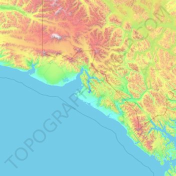
Name: Yakutat topographic map, elevation, terrain.
Location: Yakutat, Alaska, United States (58.78131 -143.89521 60.52190 -137.50000)
Average elevation: 2,648 ft
Minimum elevation: -13 ft
Maximum elevation: 19,163 ft
Alaska trails, hiking, mountain biking, running and outdoor activities
Other topographic maps
Click on a map to view its topography, its elevation and its terrain.
Fairbanks
United States > Alaska > Fairbanks North Star
Fairbanks is situated within the central Tanana Valley, characterized by a diverse and dynamic topography. The city straddles the Chena River, which flows southwest into the larger Tanana River, defining Fairbanks' southern border. To the north, a gradual incline leads into a chain of hills that ascend toward…
Average elevation: 479 ft
Homer
United States > Alaska > Kenai Peninsula
Many of the birds seen during the festival can be identified with the help of published guides that categorize distinguishable features such as, topography, silhouette, size, and color.
Average elevation: 341 ft
Ketchikan
United States > Alaska > Ketchikan
Due to its steep and forested terrain, Ketchikan is long and narrow with much of the built-up area being located along, or no more than a few city blocks from, the waterfront. Elevations of inhabited areas range from just above sea level to about 300 feet (91 m). Deer Mountain, a 3,001-foot (915 m) peak, rises…
Average elevation: 489 ft
Mt. McKinley Princess Wilderness Lodge
United States > Alaska > Matanuska-Susitna Borough
Average elevation: 804 ft
Mount Hayes
United States > Alaska > Unorganized Borough
Mount Hayes is the highest mountain in the eastern Alaska Range, in the U.S. state of Alaska. Despite not being a fourteener, it is one of the largest peaks in the United States in terms of rise above local terrain. For example, the Northeast Face rises 8,000 feet (2,440 m) in approximately 2 miles (3.2 km).…
Average elevation: 10,614 ft
Shishaldin Volcano
United States > Alaska > Aleutians East Borough
Shishaldin is located on Unimak Island, the easternmost of the Aleutian Islands. The nearest settlement to the volcano is False Pass (population ~100) at 45 km away. The view of Shishaldin from False Pass is obscured by the Round Top and Isanotski volcanoes, preventing direct observations of eruptions in many…
Average elevation: 7,001 ft
Glacier Bay National Park and Preserve
United States > Alaska > Unorganized Borough > Gustavus
Average elevation: 72 ft
Fort Yukon
United States > Alaska > Unorganized Borough > Fort Yukon
On February 7, 1984, a Terrier Malemute-type sounding rocket, with a maximum altitude of 310 miles (500 km), was launched from Fort Yukon.
Average elevation: 436 ft
Mount Crillon
United States > Alaska > Unorganized Borough
Mount Crillon is not climbed frequently, since it is an extremely challenging climb for its elevation due to its isolation. The first ascent was in 1934, by explorer Bradford Washburn on his third attempt, and longtime editor of the American Alpine Journal H. Adams Carter. They climbed via the East Ridge above…
Average elevation: 9,485 ft
Cooper Landing
United States > Alaska > Kenai Peninsula
Cooper Landing is located in the north-central part of the Kenai Peninsula at 60°29′26″N 149°47′40″W / 60.49056°N 149.79444°W / 60.49056; -149.79444 (60.490529, -149.794519). The center of the community is at the west end of Kenai Lake, where the lake flows into the Kenai River. The CDP…
Average elevation: 1,995 ft