
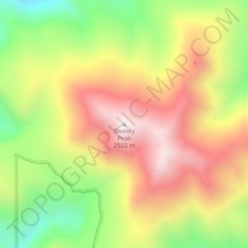
Swasey Peak topographic map
Interactive map
Click on the map to display elevation.
About this map
Name: Swasey Peak topographic map, elevation, terrain.
Location: Swasey Peak, Millard County, Utah, United States (39.38823 -113.31613 39.38833 -113.31603)
Average elevation: 8,369 ft
Minimum elevation: 6,991 ft
Maximum elevation: 9,636 ft
Utah trails, hiking, mountain biking, running and outdoor activities
Other topographic maps
Click on a map to view its topography, its elevation and its terrain.
Lake Powell
United States > Utah > San Juan County
Concrete placement started around the clock on June 17, 1960. The last bucket of concrete was poured on September 13, 1963. Over 5 million cubic yards (4,000,000 m³) of concrete make up Glen Canyon Dam. The dam is 710 feet (216 m) high and the surface elevation of the water at full-pool is approximately 3700…
Average elevation: 5,102 ft
Eagle Mountain
United States > Utah > Utah County
Eagle Mountain's climate varies drastically between the northeastern Ranches area and the southwestern City Center area. Despite being further south than Salt Lake City, both areas have cooler temperatures due to sitting at a higher elevation. The Ranches section of the city has slightly milder temperatures…
Average elevation: 5,213 ft
Bicknell
United States > Utah > Wayne County
According to the United States Census Bureau, the town has a total area of 0.62 square miles (1.6 km2), all land. It is situated at an altitude of 7,125 feet (2,172 m) above sea level, in the Rabbit Valley in south-central Utah. The Fremont River flows through the valley, which lies between 11,305-foot (3,446…
Average elevation: 7,152 ft
Richfield
United States > Utah > Sevier County
Richfield experiences a cold semi-arid climate (Köppen BSk) with four distinct seasons. Winter high temperatures average in the 30s and 40s with many milder days; low temperatures average in the teens and twenties, with a few mornings starting near or below zero. Snowfall is common, but usually melts in a day…
Average elevation: 5,443 ft
Utah Lake
United States > Utah > Utah County
Utah Lake is a shallow freshwater lake in the center of Utah County, Utah, United States. It lies in Utah Valley, surrounded by the Provo-Orem metropolitan area. The lake's only river outlet, the Jordan River, is a tributary of the Great Salt Lake. Evaporation accounts for 42% of the lake's outflow, which…
Average elevation: 4,961 ft
Monticello
United States > Utah > San Juan County
Monticello is located at the base of the Abajo Mountains, or the Blue Mountains, which are part of the Manti-La Sal National Forest. The elevation of Monticello is 7,069 feet (2,155 m). From Monticello, a tree formation on the Blue Mountains can be seen, which resembles a horse's head and neck, which can be…
Average elevation: 7,037 ft
Clarkston
United States > Utah > Cache County
The townsite of Clarkston was laid out in 1864. It was named for Israel Justus Clark, who was an early settler and the first branch president of the Church of Jesus Christ of Latter-day Saints in Clarkston. The settlers originally settled east of modern-day Clarkston in a spot known as the flat. Due to water…
Average elevation: 4,915 ft
Oakley
United States > Utah > Summit County
Oakley is located 45 miles (72 km) east of Salt Lake City on SR-32, in the Kamas Valley. With an elevation of 6,500 feet (2,000 m), it is a gateway to the Uinta Mountains. Scenic route Weber Canyon Road follows the Weber River to its headwaters; it also follows the Smith and Morehouse Creek to its reservoir in…
Average elevation: 6,716 ft
Eureka
United States > Utah > Juab County
Eureka is located in northern Juab County at 39°57′18″N 112°6′59″W / 39.95500°N 112.11639°W / 39.95500; -112.11639 (39.954974, -112.116364). It sits in the East Tintic Mountains at an elevation of 6,430 feet (1,960 m) above sea level. The northeast boundary of the city is the Utah County…
Average elevation: 6,719 ft
Kearns
United States > Utah > Salt Lake County
Kearns, in the mid to late twentieth century, saw rapid growth on the former airbase. The old streets and foundations of buildings built by the military were used as a template for the town, and homes sprang up quickly as Kearns was becoming the first suburb in Salt Lake County. By the 1970s and into the…
Average elevation: 4,619 ft