
Mauritania topographic map
Click on the map to display elevation.
Mauritania
A series of scarps face southwest, longitudinally bisecting these plains in the center of the country. The scarps also separate a series of sandstone plateaus, the highest of which is the Adrar Plateau, reaching an elevation of 500 metres or 1,600 feet. Spring-fed oases lie at the foot of some of the scarps. Isolated peaks, often rich in minerals, rise above the plateaus; the smaller peaks are called guelbs and the larger ones kedias. The concentric Guelb er Richat is a prominent feature of the north-central region. Kediet ej Jill, near the city of Zouîrât, has an elevation of 915 metres (3,000 ft) and is the highest peak. The plateaus gradually descend toward the northeast to the barren El Djouf, or "Empty Quarter," a vast region of large sand dunes that merges into the Sahara Desert. To the west, between the ocean and the plateaus, are alternating areas of clayey plains (regs) and sand dunes (ergs), some of which shift from place to place, gradually moved by high winds. The dunes generally increase in size and mobility toward the north.
About this map
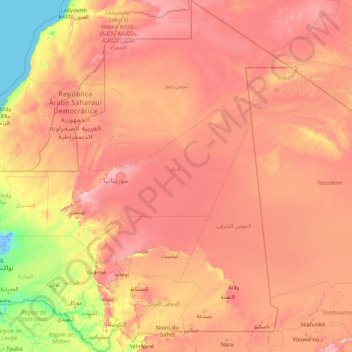
Name: Mauritania topographic map, elevation, terrain.
Location: Mauritania (14.72099 -17.23810 27.31494 -4.83333)
Average elevation: 860 ft
Minimum elevation: -10 ft
Maximum elevation: 2,992 ft
Other topographic maps
Click on a map to view its topography, its elevation and its terrain.
San Francisco Bay Area
United States > California > San Francisco
The San Francisco Bay Area is characterized by a diverse and dynamic topography shaped by geological processes over millions of years. This region features a combination of coastal plains, steep hills, and rugged mountains, all influenced by the tectonic activity associated with the nearby San Andreas Fault…
Average elevation: 371 ft
Boise
United States > Idaho > Ada County
Boise (locally /ˈbɔɪsi/ BOY-see) is the capital and most populous city of the U.S. state of Idaho and is the county seat of Ada County. As of the 2020 census, there were 235,684 people residing in the city. On the Boise River in southwestern Idaho, it is 41 miles (66 km) east of the Oregon border and 110…
Average elevation: 3,412 ft
Europe
Europe's topography is characterized by a striking contrast between its rugged southern mountains and the expansive plains of the north. The continent is often described as a "peninsula of peninsulas," featuring major peninsulas like the Iberian, Italian, and Balkan, each with unique geological features. In…
Average elevation: 732 ft
Evergreen
United States > Colorado > Jefferson County
Evergreen sits at an elevation of 7,220 feet (2,200 m) in the Rocky Mountains, 19 miles west of Denver, Colorado. Its addresses are oriented according to the Street_system_of_Denver.
Average elevation: 7,575 ft
Flagstaff
United States > Arizona > Coconino County
Flagstaff, located in Coconino County, Arizona, is characterized by its diverse topography, primarily shaped by its high elevation and volcanic activity. Sitting at around 7,000 feet (approximately 2,130 meters), the city is surrounded by the expansive Coconino National Forest, which features a blend of…
Average elevation: 7,139 ft
Atlanta
United States > Georgia > Fulton County
Atlanta occupies a high, rolling part of the Georgia Piedmont, a physiographic region described as a landscape of low hills and narrow valleys between the Blue Ridge Mountains and the Upper Coastal Plain. Around downtown and Fulton County, the terrain is gently dissected rather than flat, with broad urban…
Average elevation: 935 ft
Cincinnati
United States > Ohio > Hamilton County
Cincinnati has several standard modes of transportation including sidewalks, roads, public transit, bicycle paths and airports. The city's hills preclude the regular street grid common to many cities built up in the 19th century, and outside of the downtown basin, regular street grids are rare except for in…
Average elevation: 738 ft
North America
North America's topography is characterized by its diverse and dramatic landscapes, stretching from the towering Rocky Mountains in the west to the expansive Great Plains in the central region, and the rugged Appalachian Mountains in the east. The Rocky Mountains, which include peaks exceeding 20,000 feet…
Average elevation: 965 ft
Baltimore
Baltimore exhibits a diverse topography that plays a significant role in its character and development. Situated along the Patapsco River, which flows into the Chesapeake Bay, the city is positioned on the fall line that separates the Piedmont Plateau to the west from the Atlantic Coastal Plain to the east.…
Average elevation: 213 ft
Africa
Africa's topography is a complex tapestry of plateaus, mountains, valleys, and deserts. The continent is dominated by vast plateaus, with elevations averaging around 1,000 meters (3,281 feet), especially prominent in the south and east. The Ethiopian Highlands, often referred to as the "Roof of Africa," rise…
Average elevation: 1,516 ft
Port Charlotte
United States > Florida > Charlotte County
Port Charlotte is characterized by a predominantly flat and low-lying terrain, typical of Florida’s coastal landscape. The area features a network of waterways, including the Peace River and Charlotte Harbor, which provide ample opportunities for recreational activities like boating and fishing. Elevations…
Average elevation: 13 ft
Mexico City
Mexico > Mexico City > Mexico City
Mexico City is located in the Valley of Mexico, sometimes called the Basin of Mexico. This valley is located in the Trans-Mexican Volcanic Belt in the high plateaus of south-central Mexico. It has a minimum altitude of 2,200 meters (7,200 feet) above sea level and is surrounded by mountains and volcanoes that…
Average elevation: 7,615 ft
Madison
United States > Wisconsin > Dane County
The city is sometimes described as The City of Four Lakes, comprising the four successive lakes of the Yahara River: Lake Mendota ("Fourth Lake"), Lake Monona ("Third Lake"), Lake Waubesa ("Second Lake") and Lake Kegonsa ("First Lake"), although Waubesa and Kegonsa are not actually in Madison, but just south…
Average elevation: 948 ft
Lutz
United States > Florida > Hillsborough County > Tampa
Lutz is characterized by a gently rolling topography that showcases the distinctive features of the central Florida landscape. The area has an average elevation of about 70 feet (21 meters) above sea level, contributing to its mild undulations rather than dramatic elevation changes. The terrain is marked by a…
Average elevation: 66 ft
City of London
United Kingdom > England > City of London > City of London
The elevation of the City ranges from sea level at the Thames to 21.6 metres (71 ft) at the junction of High Holborn and Chancery Lane. Two small but notable hills are within the historic core, Ludgate Hill to the west and Cornhill to the east. Between them ran the Walbrook, one of the many "lost" rivers or…
Average elevation: 138 ft
Fairbanks
United States > Alaska > Fairbanks North Star
Fairbanks is situated within the central Tanana Valley, characterized by a diverse and dynamic topography. The city straddles the Chena River, which flows southwest into the larger Tanana River, defining Fairbanks' southern border. To the north, a gradual incline leads into a chain of hills that ascend toward…
Average elevation: 479 ft
Loveland Pass
Loveland Pass is a high mountain pass in north-central Colorado, at an elevation of 11,990 feet (3,655 m) above sea level in the Rocky Mountains of the Western United States.
Average elevation: 11,939 ft
Fogelsville
United States > Pennsylvania > Lehigh County > Upper Macungie Township
Average elevation: 509 ft
Placerville
United States > California > Placerville
The region east of Placerville, popularly known as Apple Hill and Pleasant Valley, is becoming a center for wine production. The wine region is officially designated as the El Dorado AVA. The largest wineries in the area are Boeger, Lava Cap and Madrona, but most of the 30 plus wineries surrounding Placerville…
Average elevation: 1,926 ft
Gulf of Mexico
Average elevation: 66 ft
Twentynine Palms
United States > California > Twentynine Palms
According to the United States Census Bureau, the city has a total area of 59.1 square miles (153 km2), all land. The city is at an elevation of 1,988 feet (606 m). The Marine Corps Air Ground Combat Center Twentynine Palms is located there.
Average elevation: 2,264 ft
Palm Harbor
United States > Florida > Pinellas County
Palm Harbor is characterized by its unique topography, which features a relatively rare hilly landscape for the region. Unlike much of the surrounding areas in Pinellas County, which are predominantly flat, Palm Harbor includes elevations that can reach up to about 75 feet above sea level. This elevation gives…
Average elevation: 30 ft
Kathmandu
Nepal > Bagmati Province > Kathmandu
Kathmandu is located at an elevation of approximately 4,600 feet (1,400 meters) within the Kathmandu Valley. This valley is characterized by a bowl-like topography, encircled by the lower Himalayan ranges, which rise sharply in the north, culminating in peaks that exceed 24,000 feet (7,300 meters). The…
Average elevation: 5,046 ft
Ponte Vedra Beach
United States > Florida > Saint Johns County > Ponte Vedra Beach
Ponte Vedra Beach is characterized by its gently rolling terrain that is primarily flat and lies only about 15 feet above sea level. The landscape is predominantly shaped by coastal dunes and the proximity to the Atlantic Ocean, resulting in sandy beaches interspersed with vegetation typical of barrier island…
Average elevation: 10 ft
Clinton, NY
United States > New York > Oneida County > Town of Kirkland > Village of Clinton
Average elevation: 623 ft
Laytonville
United States > California > Mendocino County
Laytonville is a census-designated place (CDP) in Mendocino County, California, United States. It is located 23 miles (37 km) north-northwest of Willits, at an elevation of 1,670 feet (510 m). The population was 1,152 at the 2020 census, down from 1,227 at the 2010 census.
Average elevation: 1,949 ft
Air Force Academy
United States > Colorado > El Paso County > Colorado Springs
The campus of the academy covers 18,455 acres (29 sq mi; 75 km2) on the east side of the Rampart Range of the Rocky Mountains, just north of Colorado Springs. Its elevation is normally given as 7,258 feet (2,212 m) above sea level, which is at the cadet area. The academy was designed by Skidmore, Owings and…
Average elevation: 7,080 ft
Sebastopol
United States > California > Sonoma County
Sebastopol's elevation is 65 to 250 feet (20 to 76 meters) above sea level. Its downtown is at the intersection of State Route 12 and State Route 116 (Gravenstein Highway), approximately 9 mi (14 km) west of U.S. Route 101.
Average elevation: 226 ft
East Hampton
United States > New York > Suffolk County > East Hampton > Village of East Hampton
Average elevation: 39 ft
Dundalk
United States > Maryland > Baltimore County
Most of Dundalk is flat and very near sea level, with a few small hills close to the city of Baltimore to the west. Dundalk is part of the Atlantic Coastal Plain. Elevations range from sea level on the shore of the Chesapeake Bay to approximately 40 feet (12 m) above sea level along the northern reaches of…
Average elevation: 108 ft
Parrish
United States > Florida > Manatee County
Parrish features a predominantly flat terrain with an average elevation of approximately 36 feet above sea level. The area's landscape is characterized by gently rolling hills and low-lying regions, making it typical of the Central Florida topography. Surrounding Parrish are numerous wetlands and drainage…
Average elevation: 39 ft
Upper Black Eddy
United States > Pennsylvania > Bucks County > Bridgeton Township
Average elevation: 328 ft
Alcatraz Island
United States > California > San Francisco
Alcatraz Island view from the west. Image shot from an altitude of approximately 1,800 ft (549 m).
Average elevation: 0 ft
Yucca Valley
United States > California > San Bernardino County
Yucca Valley lies in the middle of the Morongo Basin at a base elevation of 3,300 feet. Joshua Tree National Park is adjacent to its southern border.
Average elevation: 3,629 ft
Ball Ground
United States > Georgia > Cherokee County > Ball Ground
According to the United States Census Bureau, the city has a total area of 5.8 square miles (15.1 km2), of which 0.031 square miles (0.08 km2), or 0.50%, is water. The city's elevation averages around 1,100 feet (340 m) above sea level, ranging from just over 1,000 feet (300 m) in the valleys to around 1,200…
Average elevation: 1,089 ft
Dallas
United States > Texas > Dallas County
Dallas and its surrounding area are mostly flat. The city lies at elevations ranging from 450 to 550 feet (137 to 168 m) above sea level. The western edge of the Austin Chalk Formation, a limestone escarpment (also known as the "White Rock Escarpment"), rises 230 feet (70 m) and runs roughly north–south…
Average elevation: 518 ft
Albuquerque
United States > New Mexico > Bernalillo County
Albuquerque is located in north-central New Mexico. To its east are the Sandia–Manzano Mountains. The Rio Grande flows north to south through its center, while the West Mesa and Petroglyph National Monument make up the western part of the city. Albuquerque has one of the highest elevations of any major city…
Average elevation: 5,482 ft
Tucson
United States > Arizona > Pima County > Tucson
The city's elevation is 2,643 ft (806 m) above sea level (as measured at the Tucson International Airport). Tucson is on an alluvial plain in the Sonoran Desert, surrounded by five minor ranges of mountains: the Santa Catalina Mountains and the Tortolita Mountains to the north, the Santa Rita Mountains to the…
Average elevation: 2,743 ft