
Mauritania topographic map
Click on the map to display elevation.
Mauritania
A series of scarps face southwest, longitudinally bisecting these plains in the center of the country. The scarps also separate a series of sandstone plateaus, the highest of which is the Adrar Plateau, reaching an elevation of 500 metres or 1,600 feet. Spring-fed oases lie at the foot of some of the scarps. Isolated peaks, often rich in minerals, rise above the plateaus; the smaller peaks are called guelbs and the larger ones kedias. The concentric Guelb er Richat is a prominent feature of the north-central region. Kediet ej Jill, near the city of Zouîrât, has an elevation of 915 metres (3,000 ft) and is the highest peak. The plateaus gradually descend toward the northeast to the barren El Djouf, or "Empty Quarter," a vast region of large sand dunes that merges into the Sahara Desert. To the west, between the ocean and the plateaus, are alternating areas of clayey plains (regs) and sand dunes (ergs), some of which shift from place to place, gradually moved by high winds. The dunes generally increase in size and mobility toward the north.
About this map
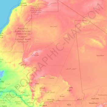
Name: Mauritania topographic map, elevation, terrain.
Location: Mauritania (14.72099 -17.23810 27.31494 -4.83333)
Average elevation: 860 ft
Minimum elevation: -10 ft
Maximum elevation: 2,992 ft
Other topographic maps
Click on a map to view its topography, its elevation and its terrain.
San Francisco Bay Area
United States > California > San Francisco
The San Francisco Bay Area is characterized by a diverse and dynamic topography shaped by geological processes over millions of years. This region features a combination of coastal plains, steep hills, and rugged mountains, all influenced by the tectonic activity associated with the nearby San Andreas Fault…
Average elevation: 371 ft
Europe
Europe's topography is characterized by a striking contrast between its rugged southern mountains and the expansive plains of the north. The continent is often described as a "peninsula of peninsulas," featuring major peninsulas like the Iberian, Italian, and Balkan, each with unique geological features. In…
Average elevation: 732 ft
City of London
United Kingdom > England > City of London > City of London
The elevation of the City ranges from sea level at the Thames to 21.6 metres (71 ft) at the junction of High Holborn and Chancery Lane. Two small but notable hills are within the historic core, Ludgate Hill to the west and Cornhill to the east. Between them ran the Walbrook, one of the many "lost" rivers or…
Average elevation: 138 ft
Mexico City
Mexico > Mexico City > Mexico City
Mexico City is located in the Valley of Mexico, sometimes called the Basin of Mexico. This valley is located in the Trans-Mexican Volcanic Belt in the high plateaus of south-central Mexico. It has a minimum altitude of 2,200 meters (7,200 feet) above sea level and is surrounded by mountains and volcanoes that…
Average elevation: 7,615 ft
Fairbanks
United States > Alaska > Fairbanks North Star
Fairbanks is situated within the central Tanana Valley, characterized by a diverse and dynamic topography. The city straddles the Chena River, which flows southwest into the larger Tanana River, defining Fairbanks' southern border. To the north, a gradual incline leads into a chain of hills that ascend toward…
Average elevation: 479 ft
Flagstaff
United States > Arizona > Coconino County
Flagstaff, located in Coconino County, Arizona, is characterized by its diverse topography, primarily shaped by its high elevation and volcanic activity. Sitting at around 7,000 feet (approximately 2,130 meters), the city is surrounded by the expansive Coconino National Forest, which features a blend of…
Average elevation: 7,139 ft
North America
North America's topography is characterized by its diverse and dramatic landscapes, stretching from the towering Rocky Mountains in the west to the expansive Great Plains in the central region, and the rugged Appalachian Mountains in the east. The Rocky Mountains, which include peaks exceeding 20,000 feet…
Average elevation: 965 ft
Ramona
United States > California > San Diego County
In January 2006, Ramona Valley was designated the country's 162nd American Viticultural Area (AVA) by the Alcohol and Tobacco Tax and Trade Bureau, which recognized the area for its distinctive microclimate, elevation, and soil attributes.
Average elevation: 1,539 ft
Santa Cruz Mountains
United States > California > Santa Clara County
The Santa Cruz Mountains are a region of great biological diversity, encompassing cool, moist coastal ecosystems as well as warm, dry chaparral. Much of the area in the Santa Cruz mountains is considered temperate rainforest. In valleys and moist ocean-facing slopes some of the southernmost coast redwoods…
Average elevation: 755 ft
Baltimore
Baltimore exhibits a diverse topography that plays a significant role in its character and development. Situated along the Patapsco River, which flows into the Chesapeake Bay, the city is positioned on the fall line that separates the Piedmont Plateau to the west from the Atlantic Coastal Plain to the east.…
Average elevation: 213 ft
Albuquerque
United States > New Mexico > Bernalillo County
Albuquerque is located in north-central New Mexico. To its east are the Sandia–Manzano Mountains. The Rio Grande flows north to south through its center, while the West Mesa and Petroglyph National Monument make up the western part of the city. Albuquerque has one of the highest elevations of any major city…
Average elevation: 5,482 ft
Parrish
United States > Florida > Manatee County
Parrish features a predominantly flat terrain with an average elevation of approximately 36 feet above sea level. The area's landscape is characterized by gently rolling hills and low-lying regions, making it typical of the Central Florida topography. Surrounding Parrish are numerous wetlands and drainage…
Average elevation: 39 ft
Cincinnati
United States > Ohio > Hamilton County
Cincinnati has several standard modes of transportation including sidewalks, roads, public transit, bicycle paths and airports. The city's hills preclude the regular street grid common to many cities built up in the 19th century, and outside of the downtown basin, regular street grids are rare except for in…
Average elevation: 738 ft
Tucson
United States > Arizona > Pima County > Tucson
The city's elevation is 2,643 ft (806 m) above sea level (as measured at the Tucson International Airport). Tucson is on an alluvial plain in the Sonoran Desert, surrounded by five minor ranges of mountains: the Santa Catalina Mountains and the Tortolita Mountains to the north, the Santa Rita Mountains to the…
Average elevation: 2,743 ft
Port Charlotte
United States > Florida > Charlotte County
Port Charlotte is characterized by a predominantly flat and low-lying terrain, typical of Florida’s coastal landscape. The area features a network of waterways, including the Peace River and Charlotte Harbor, which provide ample opportunities for recreational activities like boating and fishing. Elevations…
Average elevation: 13 ft
Palm Harbor
United States > Florida > Pinellas County
Palm Harbor is characterized by its unique topography, which features a relatively rare hilly landscape for the region. Unlike much of the surrounding areas in Pinellas County, which are predominantly flat, Palm Harbor includes elevations that can reach up to about 75 feet above sea level. This elevation gives…
Average elevation: 30 ft
Gulf of Mexico
Average elevation: 66 ft
Susanville
United States > California > Lassen County
Susanville (formerly known as Rooptown) is a town in and is the county seat of Lassen County, California, United States. Susanville is located on the Susan River in the southern part of the county, at an elevation of 4,186 feet (1,276 m). Its population is 16,728 as of the 2020 census, down from 17,947 from…
Average elevation: 4,413 ft
Atlanta
United States > Georgia > Fulton County
Atlanta occupies a high, rolling part of the Georgia Piedmont, a physiographic region described as a landscape of low hills and narrow valleys between the Blue Ridge Mountains and the Upper Coastal Plain. Around downtown and Fulton County, the terrain is gently dissected rather than flat, with broad urban…
Average elevation: 935 ft
Florida Keys
United States > Florida > Monroe County
The Florida Keys, an archipelago extending about 120 miles from the southeastern tip of Florida, feature a unique topography characterized by low-lying coral islands and a series of intricate waterways. Most islands are less than 5 feet above sea level, contributing to their vulnerability to storm surges and…
Average elevation: 0 ft
Quezon City
Quezon City is characterized by a diverse topography that features a mix of flatlands, rolling hills, and elevated areas, particularly in the eastern and northern parts of the city. The elevation generally ranges from about 25 to 300 feet above sea level, with higher elevations found in areas like the La Mesa…
Average elevation: 187 ft
Idyllwild-Pine Cove
United States > California > Riverside County
"Mile-high Idyllwild" is a mountain resort about one-mile (1,600 m) in altitude. Idyllwild is flanked by two large rock formations, Tahquitz Peak and Suicide Rock (also known as Lily Rock), which are famous in Southern California rock-climbing circles. It offers no skiing, so "the Hill" has been minimally…
Average elevation: 5,728 ft
Augusta
United States > Georgia > Augusta
As with the rest of the state, Augusta has a humid subtropical climate (Köppen Cfa), with short, mild winters, very hot, humid summers, and a wide diurnal temperature variation throughout much of the year, despite its low elevation and moisture. The monthly daily average temperature ranges from 45.4 °F (7.4…
Average elevation: 295 ft
Estes Park
United States > Colorado > Larimer County
Estes Park sits at an elevation of 7,522 feet (2,293 m) on the front range of the Rocky Mountains at the eastern entrance of the Rocky Mountain National Park. Its location is 40°22′22″N 105°31′09″W / 40.372856°N 105.519136°W / 40.372856; -105.519136. Its north, south and east extremities…
Average elevation: 7,904 ft
Scottish Highlands
United Kingdom > Scotland > Highland
The Scottish Highlands are renowned for their rugged, mountainous terrain that dominates much of the region. Stretching across the northern and central parts of Scotland, the landscape is shaped by ancient geological forces, including the Caledonian Orogeny, which caused significant tectonic collisions…
Average elevation: 2,976 ft
Markleeville
United States > California > Alpine County
Markleeville hosts an annual bicycle ride called the Death Ride - Tour of the California Alps. The route goes over five passes for a total distance of 129 miles and over 15,000 feet of elevation gain. In 2010 3,500 riders participated and 2,417 completed the full course of 5 mountain passes.
Average elevation: 5,866 ft
Kula
United States > Hawaii > Maui County
Kula is a district and census-designated place (CDP) of Maui, Hawaii, that stretches across the "up-country", the western-facing slopes of Haleakalā, from Makawao to Kanaio. Most of the residential areas lie between about 500 to 1,100 m (1,600 to 3,600 ft) in elevation. The district has traditionally been…
Average elevation: 2,428 ft
San Fernando Valley
United States > California > Los Angeles County > Los Angeles
Average elevation: 1,627 ft
Boise
United States > Idaho > Ada County
Boise (locally /ˈbɔɪsi/ BOY-see) is the capital and most populous city of the U.S. state of Idaho and is the county seat of Ada County. As of the 2020 census, there were 235,684 people residing in the city. On the Boise River in southwestern Idaho, it is 41 miles (66 km) east of the Oregon border and 110…
Average elevation: 3,412 ft
Monterrey
Mexico > Nuevo León > Monterrey
The city of Monterrey is 540 metres (1,770 ft) above sea level in the northeastern state of Nuevo León. Monterrey translated literally from Spanish to English is "King Mount" or "King Mountain", and folk etymology claims that this refers to the city's topography and the large mountains that surround it…
Average elevation: 2,470 ft
Chino Valley
United States > Arizona > Yavapai County
The town is in north-central Arizona, on state Highway 89, 15 miles (24 km) north of Prescott and 35 miles (56 km) south of Ash Fork, which is on Interstate 40. Chino Valley is at an elevation of about 4,750 feet (1,450 m).
Average elevation: 4,770 ft
Lynx Lake
United States > Arizona > Yavapai County
Lynx Lake, Arizona, is a 55-acre (220,000 m2) reservoir located within Prescott National Forest, approximately 5 miles (8.0 km) east of Prescott, Arizona, in the Bradshaw Mountains. The lake is located at 5,530 feet (1,690 m) elevation and is stocked for fishing. It is one of the most popular recreation areas…
Average elevation: 5,663 ft
Himalayas
Nepal > Koshi Province > Solukhumbu
The Himalayas present a dramatic and varied topography characterized by towering peaks, deep valleys, and extensive glaciers. This majestic mountain range features some of the highest elevations on Earth, including Mount Everest, which rises to 29,035 feet. The terrain is marked by steep, jagged ridges and…
Average elevation: 24,787 ft
Appalachian Mountains
United States > North Carolina > Yancey County
The Appalachian Mountains (French: Appalaches), often called the Appalachians, are a system of mountains in eastern to northeastern North America. The Appalachians first formed roughly 480 million years ago during the Ordovician Period. They once reached elevations similar to those of the Alps and the Rocky…
Average elevation: 4,800 ft
Africa
Africa's topography is a complex tapestry of plateaus, mountains, valleys, and deserts. The continent is dominated by vast plateaus, with elevations averaging around 1,000 meters (3,281 feet), especially prominent in the south and east. The Ethiopian Highlands, often referred to as the "Roof of Africa," rise…
Average elevation: 1,516 ft
Englewood
Englewood features a diverse topography characterized by flat coastal plains and gently rolling terrain. The area is predominantly low-lying, with elevations rarely exceeding 20 feet above sea level, making it susceptible to tidal influences from the Gulf of Mexico. The landscape is interspersed with wetlands,…
Average elevation: 10 ft
Estes Park
United States > Colorado > Larimer County
Estes Park sits at an elevation of 7,522 feet (2,293 m) on the front range of the Rocky Mountains at the eastern entrance of the Rocky Mountain National Park. Its location is 40°22′22″N 105°31′09″W / 40.372856°N 105.519136°W / 40.372856; -105.519136. Its north, south and east extremities…
Average elevation: 8,343 ft
Grass Valley
United States of America > California > Grass Valley
The city of Grass Valley is the largest city in the western region of Nevada County, California, United States. Situated at roughly 2,500 feet (760 m) elevation in the western foothills of the Sierra Nevada mountain range, this historic northern Gold Country city is 57 miles (92 km) by car from the state…
Average elevation: 2,549 ft
Berkeley Springs
United States > West Virginia > Morgan County > Berkeley Springs
While vacationing in the area in 1767, Washington noted how busy the colonial town had become. Lord Fairfax had built a summer home there and a "private bath", making the area a popular destination for Virginia's social elite. With the advent of independence, An act for establishing a town at the Warm Springs…
Average elevation: 751 ft
Indianapolis
United States > Indiana > Indianapolis
Indianapolis is within the Tipton Till Plain, a flat to gently sloping terrain underlain by glacial deposits known as till. The lowest point in the city is about 650 feet (198 m) above mean sea level, with the highest natural elevation at about 900 feet (274 m) above sea level. Few hills or short ridges, known…
Average elevation: 791 ft
Toronto
Despite its deep ravines, Toronto is not remarkably hilly, but its elevation does increase steadily away from the lake. Elevation differences range from 76.5 metres (251 ft) above sea level at the Lake Ontario shore to 209 m (686 ft) ASL near the York University grounds in the city's north end at the…
Average elevation: 371 ft
Austria
According to the Köppen Climate Classification Austria has the following climate types: Oceanic (Cfb), Cool/Warm-summer humid continental (Dfb), Subarctic/Subalpine (Dfc), Tundra/Alpine (ET), and Ice-Cap (EF). It is important to note though that Austria may experience very cold, severe winters, but most of…
Average elevation: 1,096 ft
Fall Creek Falls State Park
United States > Tennessee > Van Buren County
Just beyond its source, Cane Creek slowly gains strength as it absorbs Meadow Creek and several smaller streams. As the creek enters the gorge, it drops several hundred feet in less than a mile, including 45 feet (14 m) over Cane Creek Cascades and 85 feet (26 m) over Cane Creek Falls. A few hundred meters…
Average elevation: 1,719 ft
New Orleans
United States > Louisiana > Orleans Parish
Founded in 1718 by French colonists, New Orleans was once the territorial capital of French Louisiana before becoming part of the United States in the Louisiana Purchase of 1803. New Orleans in 1840 was the third most populous city in the United States, and it was the largest city in the American South from…
Average elevation: 3 ft
Crater of Diamonds State Park
United States > Arkansas > Pike County > Murfreesboro > Kimberley
Average elevation: 348 ft
Coachella Valley
United States > California > Riverside County > Palm Desert
The area is surrounded on the southwest by the Santa Rosa Mountains, by the San Jacinto Mountains to the west, the Little San Bernardino Mountains to the east and San Gorgonio Mountain to the north. These mountains peak at around 11,000 feet (3,400 m) and tend to average between 5,000 and 7,000 feet (1,500 and…
Average elevation: 236 ft