
Make a donation
Gear up for your next adventure:
As an Amazon Associate, this site earns from qualifying purchases at no extra cost to you.
Fredericksburg topographic map
Click on the map to display elevation.
Make a donation
Gear up for your next adventure:
As an Amazon Associate, this site earns from qualifying purchases at no extra cost to you.
Fredericksburg
Fredericksburg is characterized by its varied topography, which plays a significant role in the region's historical and recreational appeal. The city is situated on rolling hills that rise gently from the banks of the Rappahannock River, creating a picturesque landscape. The river itself meanders through the area, offering a natural boundary and providing fertile floodplains. Surrounding the urban center, the terrain features a mix of forests and open fields, with elevations ranging from about 40 to 200 feet above sea level. This diverse topography not only enhances the scenic beauty of Fredericksburg but also contributes to the area's ecological richness and recreational opportunities, including hiking and water sports. The undulating landscape, combined with the historic architecture, provides a unique backdrop that reflects both the natural environment and the city’s storied past.
Make a donation
Gear up for your next adventure:
As an Amazon Associate, this site earns from qualifying purchases at no extra cost to you.
About this map
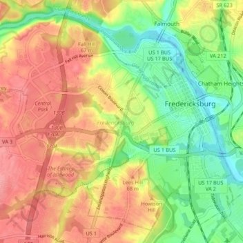
Name: Fredericksburg topographic map, elevation, terrain.
Location: Fredericksburg, Virginia, United States (38.27015 -77.53259 38.32664 -77.44679)
Average elevation: 125 ft
Minimum elevation: -7 ft
Maximum elevation: 269 ft
Virginia trails, hiking, mountain biking, running and outdoor activities
Make a donation
Gear up for your next adventure:
As an Amazon Associate, this site earns from qualifying purchases at no extra cost to you.
Other topographic maps
Click on a map to view its topography, its elevation and its terrain.
Virginia Beach
United States > Virginia > Virginia Beach
According to the United States Census Bureau, the city has a total area of 497 square miles (1,290 km2), of which 249 square miles (640 km2) is land and 248 square miles (640 km2) (49.9%) is water. It is the largest city in Virginia by total area and third-largest city land area. The average elevation is 12…
Average elevation: 7 ft
Make a donation
Gear up for your next adventure:
As an Amazon Associate, this site earns from qualifying purchases at no extra cost to you.
Make a donation
Gear up for your next adventure:
As an Amazon Associate, this site earns from qualifying purchases at no extra cost to you.
Make a donation
Gear up for your next adventure:
As an Amazon Associate, this site earns from qualifying purchases at no extra cost to you.
Blue Ridge Mountains
United States > Virginia > Botetourt County
Although the term "Blue Ridge" is sometimes applied exclusively to the eastern edge or front range of the Appalachian Mountains, the geological definition of the Blue Ridge province extends westward to the Ridge and Valley area, encompassing the Great Smoky Mountains, the Great Balsams, the Roans, the Blacks,…
Average elevation: 1,509 ft
Make a donation
Gear up for your next adventure:
As an Amazon Associate, this site earns from qualifying purchases at no extra cost to you.
Make a donation
Gear up for your next adventure:
As an Amazon Associate, this site earns from qualifying purchases at no extra cost to you.
Make a donation
Gear up for your next adventure:
As an Amazon Associate, this site earns from qualifying purchases at no extra cost to you.
Make a donation
Gear up for your next adventure:
As an Amazon Associate, this site earns from qualifying purchases at no extra cost to you.
Make a donation
Gear up for your next adventure:
As an Amazon Associate, this site earns from qualifying purchases at no extra cost to you.
Make a donation
Gear up for your next adventure:
As an Amazon Associate, this site earns from qualifying purchases at no extra cost to you.
Make a donation
Gear up for your next adventure:
As an Amazon Associate, this site earns from qualifying purchases at no extra cost to you.
Make a donation
Gear up for your next adventure:
As an Amazon Associate, this site earns from qualifying purchases at no extra cost to you.
Prince William Forest Park
United States > Virginia > Prince William County > Triangle
Average elevation: 266 ft
Make a donation
Gear up for your next adventure:
As an Amazon Associate, this site earns from qualifying purchases at no extra cost to you.
Make a donation
Gear up for your next adventure:
As an Amazon Associate, this site earns from qualifying purchases at no extra cost to you.
Make a donation
Gear up for your next adventure:
As an Amazon Associate, this site earns from qualifying purchases at no extra cost to you.
Eggleston
United States > Virginia > Giles County
It lies at an elevation of 1,821 feet.
Average elevation: 1,877 ft
Make a donation
Gear up for your next adventure:
As an Amazon Associate, this site earns from qualifying purchases at no extra cost to you.
Make a donation
Gear up for your next adventure:
As an Amazon Associate, this site earns from qualifying purchases at no extra cost to you.
Make a donation
Gear up for your next adventure:
As an Amazon Associate, this site earns from qualifying purchases at no extra cost to you.
Loudoun Valley Estates
United States > Virginia > Loudoun County
The land around Loudoun Valley Estates is gently rolling. The average elevation is 289 feet (88 m). The population density is about 500 people per square kilometer.
Average elevation: 299 ft
Make a donation
Gear up for your next adventure:
As an Amazon Associate, this site earns from qualifying purchases at no extra cost to you.
Make a donation
Gear up for your next adventure:
As an Amazon Associate, this site earns from qualifying purchases at no extra cost to you.
Make a donation
Gear up for your next adventure:
As an Amazon Associate, this site earns from qualifying purchases at no extra cost to you.
Make a donation
Gear up for your next adventure:
As an Amazon Associate, this site earns from qualifying purchases at no extra cost to you.
Make a donation
Gear up for your next adventure:
As an Amazon Associate, this site earns from qualifying purchases at no extra cost to you.
Mount Rogers
United States > Virginia > Smyth County
Mount Rogers is the highest natural point in Virginia, United States, with a summit elevation of 5,729 ft (1,746 m) above mean sea level. The summit straddles the border of Grayson and Smyth Counties, Virginia, about 6.45 mi (10.38 km) WSW of Troutdale, Virginia. Most of the mountain is contained within the…
Average elevation: 4,944 ft
Make a donation
Gear up for your next adventure:
As an Amazon Associate, this site earns from qualifying purchases at no extra cost to you.
Cumberland Gap
United States > Virginia > Lee County
The V-shaped gap serves as a gateway to the west. The base of the gap is about 300 ft (91 m) above the valley floor, even though the north side of the pass was lowered 20 ft (6.1 m) during the construction of Old U.S. Route 25E. To the south, the ridge rises 600 ft (180 m) above the pass, while to the north…
Average elevation: 1,680 ft
Make a donation
Gear up for your next adventure:
As an Amazon Associate, this site earns from qualifying purchases at no extra cost to you.
Make a donation
Gear up for your next adventure:
As an Amazon Associate, this site earns from qualifying purchases at no extra cost to you.