
Letcher County topographic map
Click on the map to display elevation.
Letcher County
The county's terrain is defined by rugged mountains and blanketed by forests. Jefferson National Forest covers a significant portion of the county. The county's highest point is Black Mountain, located in the southeastern corner of the county, with an elevation of 3,700 feet.
About this map
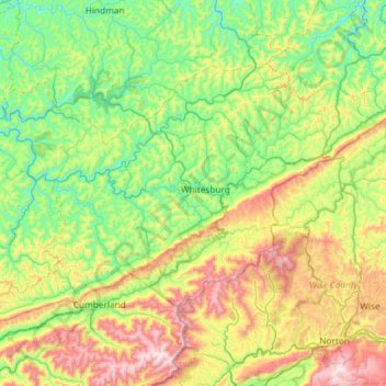
Name: Letcher County topographic map, elevation, terrain.
Location: Letcher County, Kentucky, United States (36.95417 -83.15399 37.27337 -82.56538)
Average elevation: 1,886 ft
Minimum elevation: 843 ft
Maximum elevation: 4,170 ft
Kentucky trails, hiking, mountain biking, running and outdoor activities
Other topographic maps
Click on a map to view its topography, its elevation and its terrain.
Mammoth Cave National Park
United States > Kentucky > Edmonson County > Brownsville
The upper sandstone member is known as the Big Clifty Sandstone. Thin, sparse layers of limestone interspersed within the sandstone give rise to an epikarstic zone, in which tiny conduits (cave passages too small to enter) are dissolved by the natural acidity of groundwater. The epikarstic zone concentrates…
Average elevation: 705 ft
Pleasure Ridge Park
United States > Kentucky > Jefferson County > Louisville
Average elevation: 466 ft
Iroquois Park
United States > Kentucky > Jefferson County > Louisville > Parkwood
Average elevation: 548 ft
Fort Boonesborough State Park
United States > Kentucky > Madison County > Boonesborough
Average elevation: 774 ft
Black Mountain
United States > Kentucky > Harlan County
Black Mountain is the highest mountain peak in the Commonwealth of Kentucky, United States, with a summit elevation of 4,145 feet (1,263 m) above mean sea level and a top-to-bottom height of over 2,500 feet (760 m). The summit is located at approximately 36°54′51″N 82°53′38″W / 36.91417°N…
Average elevation: 3,638 ft