
Make a donation
Gear up for your next adventure:
As an Amazon Associate, this site earns from qualifying purchases at no extra cost to you.
Base Marambio topographic map
Click on the map to display elevation.
Make a donation
Gear up for your next adventure:
As an Amazon Associate, this site earns from qualifying purchases at no extra cost to you.
Base Marambio
En el año 2012 la base contaba con una pista de aterrizaje de 1200 m y a partir de 2015 otra con 1600 m de largo por 30 m de ancho y la primera orientada a los 60/240°, con una elevación de 230 °m; disponen de balizamiento eléctrico y una línea de luces estroboscópicas tipo flash, orientada para la cabecera 24. La plataforma de estacionamiento permite la entrada de aviones Hércules C-130 con acceso a la planta de combustible; servicios concurrentes: sanidad, contraincendio; además cuenta con la ayuda necesaria para la navegación aérea y el aterrizaje en condiciones meteorológicas de escasa visibilidad.
Make a donation
Gear up for your next adventure:
As an Amazon Associate, this site earns from qualifying purchases at no extra cost to you.
About this map
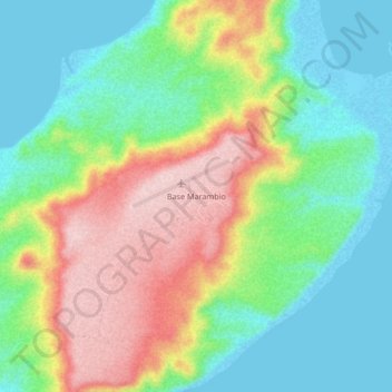
Name: Base Marambio topographic map, elevation, terrain.
Location: Base Marambio (-64.26062 -56.64769 -64.22062 -56.60769)
Average elevation: 249 ft
Minimum elevation: 0 ft
Maximum elevation: 689 ft
Make a donation
Gear up for your next adventure:
As an Amazon Associate, this site earns from qualifying purchases at no extra cost to you.
Other topographic maps
Click on a map to view its topography, its elevation and its terrain.
United States
The topography of the United States is characterized by diverse and dynamic landscapes that vary widely across the country. In the east, rolling hills and low mountains transition into the Appalachian Mountains, featuring peaks that generally reach around 6,000 feet (1,829 meters). Moving westward, the terrain…
Average elevation: 1,014 ft
Iran
Iran's topography is diverse and dominated by rugged mountain ranges, which define much of its landscape. To the west, the Zagros Mountains stretch from the northwest to the southeast, with many peaks surpassing 10,000 feet (3,048 meters) in elevation. These mountains form a rugged barrier between Iran's…
Average elevation: 2,579 ft
Florida
Florida's topography is characterized by its predominantly flat landscape, with the highest elevation being Britton Hill at just 345 feet (105 meters) above sea level, making it the lowest high point of any U.S. state. The state is primarily divided into three physiographic regions: the Atlantic Coastal Plain,…
Average elevation: 20 ft
Arizona
Arizona's topography is highly diverse, shaped by three distinct regions: the Colorado Plateau, the Basin and Range Province, and the Transition Zone. The northern Colorado Plateau is characterized by flat, high plains over 4,000 feet in elevation, including the Grand Canyon and its breathtaking cliffs. In…
Average elevation: 4,032 ft
Make a donation
Gear up for your next adventure:
As an Amazon Associate, this site earns from qualifying purchases at no extra cost to you.
Denver
United States > Colorado > Denver County > Denver
Denver, situated at an elevation of 5,280 feet (1,609 meters), is renowned as the "Mile High City." It is located in the South Platte River Valley, just east of the Rocky Mountains' foothills. The city's topography features a gently sloping landscape characterized by rolling hills and wide valleys,…
Average elevation: 5,525 ft
Seattle
United States > Washington > King County
Seattle features a diverse topography characterized by its unique geographical setting between Puget Sound and Lake Washington. The city is situated on an isthmus, which contributes to its dramatic landscape, featuring rolling hills and steep slopes that rise abruptly from the waterfront. The average elevation…
Average elevation: 131 ft
Naples
United States > Florida > Collier County
Naples features a predominantly flat and low-lying topography. The city sits at an elevation of approximately 5 to 10 feet above sea level, contributing to its coastal and marshy characteristics. The terrain is mostly characterized by sandy beaches along the Gulf of Mexico, interspersed with wetlands and…
Average elevation: 10 ft
Make a donation
Gear up for your next adventure:
As an Amazon Associate, this site earns from qualifying purchases at no extra cost to you.
Chattanooga
United States > Tennessee > Hamilton County
Chattanooga showcases a diverse and striking topography that is defined by its position within the Appalachian region. Nestled between the rugged Ridge-and-Valley Appalachians and the Cumberland Plateau, the city is framed by dramatic hills and valleys, creating a visually compelling landscape. The Tennessee…
Average elevation: 1,086 ft
Savannah
United States > Georgia > Chatham County
Savannah is characterized by a unique and varied topography shaped by its coastal location and historical development. The city is situated on a series of low bluffs along the Savannah River, which flows into the Atlantic Ocean approximately 18 miles (29 km) away. The terrain features a mix of flat coastal…
Average elevation: 13 ft
Michigan
Michigan's topography is characterized by a diverse landscape that transitions from flat plains to rugged hills. The state comprises two peninsulas, with the Upper Peninsula showcasing more pronounced elevation changes, including its highest point, Mount Arvon, which rises to 1,979 feet (603 meters). In…
Average elevation: 850 ft
New York
New York City's topography is a fascinating blend of varied elevations and unique landscapes, reflecting its diverse geography across five boroughs. Situated at the confluence of the Hudson and East Rivers, the city primarily features low-lying terrain, with the average elevation hovering around sea level.…
Average elevation: 62 ft
Make a donation
Gear up for your next adventure:
As an Amazon Associate, this site earns from qualifying purchases at no extra cost to you.
Oregon
Oregon's topography is strikingly diverse, characterized by an array of geographical features that shape its unique landscape. The state is framed by two significant mountain ranges: the Pacific Coast Range to the west and the Cascade Mountains running north to south through the center. This mountainous…
Average elevation: 3,077 ft
Chester County
According to the U.S. Census Bureau, the county has a total area of 759 square miles (1,970 km2), of which 751 square miles (1,950 km2) is land and 8.7 square miles (23 km2) (1.1%) is water. The topography consists of rolling hills and valleys and it is part of the region known as the Piedmont.
Average elevation: 407 ft
Dayton
United States > Ohio > Montgomery County
Dayton is situated on a low floodplain primarily shaped by the Great Miami River and its tributaries, including the Stillwater and Mad rivers. The city's terrain features a relatively flat landscape, with elevations averaging around 738 feet (225 meters) above sea level. This low-lying area is characterized by…
Average elevation: 886 ft
Georgia
Georgia's topography is notably diverse, characterized by five main geographic regions that each contribute to its unique landscape. The southern part of the state features the Coastal Plain, a flat, low-lying area that gently slopes toward the Atlantic Ocean and is home to the expansive Okefenokee Swamp, one…
Average elevation: 446 ft
Make a donation
Gear up for your next adventure:
As an Amazon Associate, this site earns from qualifying purchases at no extra cost to you.
Ukraine
Ukraine's topography is characterized by a striking contrast of features across its vast landscape. The country predominantly consists of fertile plains and steppes, especially in the central and southern regions, where elevations typically range from sea level to around 600 meters (1,969 feet) above sea…
Average elevation: 600 ft
Austin
United States > Texas > Travis County
Austin features a diverse and varied topography shaped by its position along the Balcones Fault. The city’s elevation ranges from about 425 feet to approximately 1,000 feet above sea level, creating a landscape characterized by rolling hills and elevated areas particularly in the western regions. To the…
Average elevation: 709 ft
Tampa
United States > Florida > Hillsborough County
Tampa is characterized by a predominantly flat topography, with an average elevation around 16 to 49 feet (5 to 15 meters) above sea level. The terrain is marked by low-lying areas and gentle slopes, with the highest points in the vicinity reaching approximately 62 feet (19 meters). This landscape is…
Average elevation: 36 ft
Make a donation
Gear up for your next adventure:
As an Amazon Associate, this site earns from qualifying purchases at no extra cost to you.
Pennsylvania
Pennsylvania's topography is characterized by its rich diversity, ranging from the rugged Appalachian Mountains in the south to the flatlands of the northern plateau. The state's elevation varies significantly, with the highest point being Mount Davis at approximately 3,213 feet (979 meters) and the lowest at…
Average elevation: 1,115 ft
Missouri
Missouri's topography is marked by a diverse array of landforms that contribute to its unique landscape. The state is characterized by four main physiographic regions: the Ozark Plateau, Dissected Till Plains, Mississippi Alluvial Plain, and the Osage Plains. The Ozark Plateau, located in the south, features…
Average elevation: 827 ft
New Orleans
United States > Louisiana > Orleans Parish
New Orleans is situated on relatively flat terrain, primarily at or slightly below sea level, with the average elevation around 6 feet above sea level. The city's landscape is characterized by a network of wetlands, rivers, and bayous, which play a crucial role in its ecology and urban planning. It lies within…
Average elevation: 3 ft
Nebraska
Nebraska is composed of two major land regions: the Dissected Till Plains and the Great Plains. The easternmost portion of the state was scoured by Ice Age glaciers; the Dissected Till Plains were left after the glaciers retreated. The Dissected Till Plains is a region of gently rolling hills; Omaha and…
Average elevation: 2,451 ft
Make a donation
Gear up for your next adventure:
As an Amazon Associate, this site earns from qualifying purchases at no extra cost to you.
Saint Petersburg
United States > Florida > Pinellas County
Saint Petersburg features a predominantly flat topography characteristic of the Gulf Coast region. The city's elevation averages around 44 feet (approximately 13.4 meters) above sea level, with some areas dipping to about 15 feet (4.6 meters). This relatively low elevation contributes to the area's…
Average elevation: 13 ft
Panama
Panama's topography is characterized by a striking diversity of landscapes that range from rugged mountains to expansive lowland plains. The interior of the country features the Central Cordillera, which includes some of the highest peaks such as Volcán Barú, reaching an elevation of about 11,400 feet (3,475…
Average elevation: 299 ft
Charleston
United States > South Carolina > Charleston County
Charleston is characterized by its relatively flat topography, with an average elevation of about 10 feet above sea level, making it prone to flooding during heavy rains and storms. The city is situated on a peninsula bordered by the Ashley River to the west and the Cooper River to the east, creating a natural…
Average elevation: 13 ft
Make a donation
Gear up for your next adventure:
As an Amazon Associate, this site earns from qualifying purchases at no extra cost to you.
Utah
Utah's topography is characterized by a stunning variety of landscapes, reflecting its geological complexity and rich natural history. The state is primarily shaped by the Colorado Plateau and the Basin and Range province, resulting in a diverse terrain that includes rugged mountain ranges, deep canyons, and…
Average elevation: 6,155 ft
Tennessee
Tennessee features a diverse and varied topography characterized by its distinct regions, which include the Appalachian Mountains, the Central Basin, and the Gulf Coastal Plain. The state’s highest point is Clingmans Dome, rising to about 6,643 feet (2,025 meters) above sea level, while the lowest point is…
Average elevation: 764 ft
Ohio
Ohio's topography is characterized by a diverse landscape that ranges from the flat plains in the north to the rolling hills and rugged terrain in the southeast. The state can be divided into several distinct regions, including the Great Lakes Plains to the north, the Central Plains in the west, and the…
Average elevation: 912 ft
North Carolina
North Carolina features a diverse topography that can be divided into three distinct regions: the Coastal Plain, the Piedmont, and the Appalachian Mountains. The Coastal Plain, which occupies the eastern part of the state, is characterized by flat and gently sloping land, with elevations typically less than…
Average elevation: 535 ft
Make a donation
Gear up for your next adventure:
As an Amazon Associate, this site earns from qualifying purchases at no extra cost to you.
Portland
United States > Oregon > Multnomah County
Portland features a striking and varied topography characterized by its location at the confluence of the Willamette and Columbia Rivers. The city lies within the fertile Willamette Valley, flanked by the snow-capped Cascade Mountains to the east, including the prominent Mount Hood, and the less elevated…
Average elevation: 253 ft
Syria
Average elevation: 1,762 ft
Pittsburgh
United States > Pennsylvania > Allegheny County
Pittsburgh, located in Allegheny County, Pennsylvania, is characterized by its distinct and varied topography, shaped by the confluence of the Allegheny, Monongahela, and Ohio rivers. The city itself is situated at an average elevation of approximately 764 feet (233 meters) above sea level, with the terrain…
Average elevation: 994 ft
Make a donation
Gear up for your next adventure:
As an Amazon Associate, this site earns from qualifying purchases at no extra cost to you.
San Francisco
San Francisco is characterized by its striking and varied topography, making it one of the most distinctive cities in the United States. The landscape features a mix of rolling hills and steep inclines, with the highest elevation reaching approximately 922 feet at Twin Peaks. The average elevation across the…
Average elevation: 213 ft
Colorado
Colorado's topography is characterized by a diverse range of elevations and landforms, making it one of the most geologically varied states in the U.S. The state is dominated by the Rocky Mountains, which run north to south and include the highest peak in the contiguous United States, Mount Elbert, towering at…
Average elevation: 6,759 ft
Phoenix
United States > Arizona > Maricopa County
Phoenix is characterized by a unique topographical landscape nestled in the Salt River Valley. This valley, at an average elevation of about 1,086 feet, is framed by several prominent mountain ranges, creating a striking contrast between the flat plains and elevated terrains. Notable peaks such as Camelback…
Average elevation: 1,578 ft
Flagstaff
United States > Arizona > Coconino County
Flagstaff, located in Coconino County, Arizona, is characterized by its diverse topography, primarily shaped by its high elevation and volcanic activity. Sitting at around 7,000 feet (approximately 2,130 meters), the city is surrounded by the expansive Coconino National Forest, which features a blend of…
Average elevation: 7,139 ft
Make a donation
Gear up for your next adventure:
As an Amazon Associate, this site earns from qualifying purchases at no extra cost to you.
Detroit
United States > Michigan > Wayne County
The city slopes gently from the northwest to southeast on a till plain composed largely of glacial and lake clay. The most notable topographical feature in the city is the Detroit Moraine, a broad clay ridge on which the older portions of Detroit and Windsor are located, rising approximately 62 feet (19 m)…
Average elevation: 614 ft
Lake Tahoe
United States > California > Placer County
Lake Tahoe is renowned for its dramatic topography, characterized by rugged mountain ranges and deep, crystal-clear waters. Nestled in the Sierra Nevada, the lake itself lies at an elevation of approximately 6,225 feet (1,897 meters) and spans about 22 miles (35 kilometers) in length and 12 miles (19…
Average elevation: 6,814 ft
Wilmington
United States > North Carolina > New Hanover County
Wilmington sits near the southeastern coast and has a low-lying, relatively flat topography with an average elevation around 36 feet above sea level. The terrain is characterized by coastal plains with minimal elevation changes, making the landscape generally flat as it gently slopes toward the Atlantic Ocean.…
Average elevation: 23 ft
Kingman
United States > Arizona > Mohave County > Kingman
Lt. Edward Fitzgerald Beale, a U.S. Navy officer in the service of the U.S. Army Corps of Topographical Engineers, was ordered by the U.S. War Department to build a federal wagon road across the 35th Parallel. His secondary orders were to test the feasibility of the use of camels as pack animals in the…
Average elevation: 3,711 ft
Make a donation
Gear up for your next adventure:
As an Amazon Associate, this site earns from qualifying purchases at no extra cost to you.
Yellowstone National Park
Yellowstone National Park's topography is characterized by a remarkable diversity of geological features shaped by its unique volcanic history and tectonic activity. The park is predominantly situated on the Yellowstone Plateau, which is part of the larger Rocky Mountain range, with elevations ranging from…
Average elevation: 8,038 ft
Vietnam
Due to differences in latitude and the marked variety in topographical relief, Vietnam's climate tends to vary considerably for each region. Vietnam is a country located in the tropics, however Northern Vietnam, including Hanoi, is considered a subtropical region by Köppen climate classification. During the…
Average elevation: 568 ft
Israel
Israel's topography is strikingly diverse, encompassing a variety of landscapes within its relatively small area of approximately 8,522 square miles (22,072 Km²). The coastal plain stretches along the Mediterranean Sea, characterized by sandy shores and fertile land that supports extensive agriculture,…
Average elevation: 1,345 ft
Argentina
In general, Argentina has four main climate types: warm, moderate, arid, and cold, all determined by the expanse across latitude, range in altitude, and relief features. Although the most populated areas are generally temperate, Argentina has an exceptional amount of climate diversity, ranging from subtropical…
Average elevation: 650 ft
Make a donation
Gear up for your next adventure:
As an Amazon Associate, this site earns from qualifying purchases at no extra cost to you.
Buffalo
United States > New York > Erie County
Buffalo is characterized by its relatively flat terrain, predominantly lying on the Erie/Ontario Lake Plain, which forms part of the Eastern Great Lakes Lowlands. The city's elevation averages around 607 feet above sea level, with minor variations, particularly in neighborhoods like University Heights, which…
Average elevation: 607 ft
Los Angeles
United States > California > Los Angeles County
Los Angeles is characterized by a diverse and dynamic topography. The city is predominantly situated in a basin bordered by mountain ranges, including the Santa Monica Mountains to the north and the San Gabriel Mountains to the east, with elevations reaching up to about 10,000 feet (3,048 meters) in certain…
Average elevation: 791 ft
Make a donation
Gear up for your next adventure:
As an Amazon Associate, this site earns from qualifying purchases at no extra cost to you.
Birmingham
United States > Alabama > Jefferson County
Birmingham has a varied and rugged topography shaped by the nearby Appalachian foothills. The city sits at an average elevation of around 600 feet (183 meters), though it is surrounded by more dramatic terrain that rises higher to 1,000 feet (305 meters) in some areas, particularly to the south and east.…
Average elevation: 633 ft
Idaho
Idaho's topography is characterized by its remarkable diversity, featuring vast mountain ranges, deep river canyons, and extensive plains. The state is home to over 75 mountain ranges, including the prominent Rocky Mountains and the majestic Sawtooth Range, with peaks like Borah Peak rising to 12,662 feet…
Average elevation: 5,030 ft
Alabama
Alabama's topography is characterized by a diverse and intricate landscape that varies significantly across its regions. In the northern and northeastern parts, the terrain features the hilly and mountainous Appalachian Highlands, including the notable Cheaha Mountain, which rises to an elevation of 2,407 feet…
Average elevation: 446 ft
Southern California
Most of Southern California has a Mediterranean-like climate, with warm and dry summers, mild and wet winters, where cool weather and freezing temperatures are rare. Southern California contains other types of climates, including semi-arid, desert and mountain, with infrequent rain and many sunny days. Summers…
Average elevation: 1,900 ft
Make a donation
Gear up for your next adventure:
As an Amazon Associate, this site earns from qualifying purchases at no extra cost to you.
Hudson River
The source of the Hudson River is Lake Tear of the Clouds in the Adirondack Park at an elevation of 4,322 feet (1,317 m). However, the river is not cartographically called the Hudson River until miles downstream. The river is named Feldspar Brook until its confluence with the Opalescent River, and then is…
Average elevation: 988 ft
Avery County
United States > North Carolina
Avery County showcases a strikingly rugged topography characterized by its placement within the Appalachian Mountains. This mountainous terrain features elevations averaging about 3,500 feet, making it one of the highest counties east of the Mississippi River. The highest peak in the county is Grassy Ridge…
Average elevation: 3,301 ft
Gatlinburg
United States > Tennessee > Sevier County
Gatlinburg is nestled within the Appalachian Mountains, specifically at the junction of the Ridge-and-Valley and the Blue Ridge provinces, making its topography notably rugged and varied. The town itself sits at an elevation of approximately 1,500 feet above sea level, surrounded by steep ridges and deep…
Average elevation: 1,893 ft
Dallas
United States > Texas > Dallas County
Dallas features a predominantly flat terrain characterized by elevations generally ranging from 450 to 550 feet (137 to 168 meters) above sea level. The landscape is shaped significantly by the western edge of the Austin Chalk Formation, a limestone escarpment known as the White Rock Escarpment, which rises…
Average elevation: 525 ft
Make a donation
Gear up for your next adventure:
As an Amazon Associate, this site earns from qualifying purchases at no extra cost to you.
Clearwater
United States > Florida > Pinellas County
Clearwater, situated on the western coast of Florida, features a relatively flat topography typical of the Gulf Coast region. The city lies at an average elevation of around 30 feet above sea level, characterized by gently rolling terrain that transitions smoothly into the expansive beaches along the Gulf of…
Average elevation: 26 ft
San Antonio
United States > Texas > Bexar County
San Antonio features a diverse topography characterized by gently rolling hills and flat plains. The city's elevation averages around 650 feet above sea level, but nearby areas can reach heights of up to 1,300 feet in certain locations like Cross Mountain. The landscape is part of the southern edge of the…
Average elevation: 810 ft
Ann Arbor
United States > Michigan > Washtenaw County
Ann Arbor features a varied topography characterized by rolling hills and valleys shaped by glacial activity. The city is situated along the Huron River, which carves its way through the landscape, creating steep banks and fertile floodplains. Elevations range from approximately 750 feet (230 meters) along the…
Average elevation: 879 ft
Make a donation
Gear up for your next adventure:
As an Amazon Associate, this site earns from qualifying purchases at no extra cost to you.
Atlanta
United States > Georgia > Fulton County
Atlanta features a varied topography characterized by its rolling hills and elevated terrain. The city sits at an average elevation of approximately 1,050 feet (320 meters) above sea level, with elevations ranging from about 725 feet (221 meters) to 1,175 feet (358 meters) in the surrounding areas. This…
Average elevation: 932 ft
Worcester
United States > Massachusetts > Worcester County
Worcester is known for being particularly snowy in the cold months, sometimes even experiencing autumn blizzards. The city averages 48.1 inches (1,220 mm) of precipitation a year, as well as an average of 72.9 inches (185 cm) of snowfall a season, receiving far more snow than coastal locations less than 40…
Average elevation: 610 ft
Alaska
Alaska's topography is characterized by dramatic contrasts, featuring a diverse array of mountainous regions, vast plains, and intricate coastlines. The Alaska Range, home to Denali, rises to an elevation of 20,310 feet, making it the highest peak in North America. This mountain range exhibits significant…
Average elevation: 679 ft
Louisiana
Louisiana's topography is defined by a variety of landscapes that reflect both its coastal and inland characteristics. Much of the state consists of low-lying plains, including the Mississippi Alluvial Plain, where the fertile soils of the delta create an area vital for agriculture. The eastern region near the…
Average elevation: 128 ft
Make a donation
Gear up for your next adventure:
As an Amazon Associate, this site earns from qualifying purchases at no extra cost to you.
Make a donation
Gear up for your next adventure:
As an Amazon Associate, this site earns from qualifying purchases at no extra cost to you.
Peoria
United States > Arizona > Maricopa County
Peoria, located in Maricopa County, Arizona, is set within the expansive Salt River Valley. The city's terrain is generally flat, with an average elevation of around 1,122 feet (342 meters) above sea level. However, as you move northward, the landscape gradually transitions into the foothills of the…
Average elevation: 1,657 ft
Philadelphia
United States > Pennsylvania > Philadelphia County
Philadelphia, located at the confluence of the Delaware and Schuylkill Rivers, features a diverse topography characterized by its gentle slopes and valleys. The city lies on the Atlantic Seaboard Fall Line, transitioning from the flat Coastal Plain to the more rugged Piedmont region. This unique geographical…
Average elevation: 144 ft
Vero Beach
United States > Florida > Indian River County
Vero Beach, located along Florida's Atlantic coast, features relatively flat and low-lying terrain. The area has an average elevation of around 25 feet above sea level, with the highest point reaching about 40 feet. This coastal region is predominantly characterized by sandy beaches and wetlands, interspersed…
Average elevation: 20 ft
Make a donation
Gear up for your next adventure:
As an Amazon Associate, this site earns from qualifying purchases at no extra cost to you.
Castle Rock
United States > Colorado > Douglas County
Castle Rock is located at 39°22′20″N 104°51′22″W / 39.37222°N 104.85611°W / 39.37222; -104.85611 (39.372212, −104.856090) at an elevation of 6,224 feet (1,897 m). Castle Rock is in central Colorado at the junction of Interstate 25 and State Highway 86, 28 mi (45 km) south of downtown…
Average elevation: 6,404 ft
Tacoma
United States > Washington > Pierce County
Tacoma is at 47°14′29″N 122°27′34″W / 47.24139°N 122.45944°W / 47.24139; -122.45944 (47.241371, −122.459389). Its official elevation is 381 feet (116 m), varying between sea level and about 500 feet (150 m).
Average elevation: 220 ft
Jersey City
United States > New Jersey > Hudson County
Jersey City has a varied topography shaped by its coastal and urban setting along the lower Hudson River. This area, largely at low elevation, sits mostly around 20 feet above sea level, with extensive flatlands near the riverbanks but modest rises inland, leading to subtle hills within the city's dense urban…
Average elevation: 30 ft
Colorado Springs
United States > Colorado > El Paso County
Colorado Springs boasts a diverse and striking topography characterized by its high elevation and mountainous terrain. Nestled at approximately 6,035 feet (1,839 meters) above sea level, the city is flanked by the majestic Pikes Peak, which rises dramatically to 14,115 feet (4,302 meters), forming part of the…
Average elevation: 7,388 ft
Make a donation
Gear up for your next adventure:
As an Amazon Associate, this site earns from qualifying purchases at no extra cost to you.
Roanoke
Roanoke is characterized by a diverse topography, nestled within the Appalachian Mountains and the scenic Blue Ridge region. The city is situated at an elevation of approximately 1,100 feet, with the surrounding terrain consisting of rolling hills and valleys, predominantly shaped by the nearby Roanoke River.…
Average elevation: 1,093 ft
Asheville
United States > North Carolina > Buncombe County
Asheville, located in Buncombe County, North Carolina, is characterized by a diverse and picturesque topography primarily shaped by its position within the Blue Ridge Mountains. The city itself sits at an elevation of approximately 2,200 feet, surrounded by peaks that rise significantly higher, such as Mount…
Average elevation: 2,385 ft
Cincinnati
United States > Ohio > Hamilton County
Cincinnati features a distinctive topography characterized by its rolling hills and valleys. The city is situated on the north bank of the Ohio River, where the terrain rises sharply from the riverfront, reaching elevations of approximately 980 feet (299 meters) in some areas. The average elevation throughout…
Average elevation: 728 ft
Orlando
United States > Florida > Orange County
Orlando features a predominantly flat terrain characterized by gentle hills and low-lying areas, with elevations typically ranging from 50 to 100 feet above sea level. Despite its overall flatness, the topography includes marshes and wetlands due to the presence of numerous lakes and rivers, contributing to a…
Average elevation: 95 ft
Make a donation
Gear up for your next adventure:
As an Amazon Associate, this site earns from qualifying purchases at no extra cost to you.
North Port
United States > Florida > Sarasota County
North Port features a predominantly flat and low-lying topography characteristic of the region. The area is situated at an elevation of approximately 20 feet above sea level, with much of the terrain comprising wetlands, pine forests, and small lakes, interspersed with residential developments. The Myakka…
Average elevation: 20 ft
Kansas City
United States > Missouri > Jackson County
Kansas City features a diverse topography characterized by rolling hills and valleys, with elevations ranging from about 794 to 997 feet above sea level. The landscape is shaped by the confluence of the Missouri and Kansas rivers, resulting in a mix of elevated areas and flat river plains. The region's average…
Average elevation: 909 ft
Paris
France > Ile-de-France > Paris
Paris in its early history had only the rivers Seine and Bièvre for water. From 1809, the Canal de l'Ourcq provided Paris with water from less-polluted rivers to the north-east of the capital. From 1857, the civil engineer Eugène Belgrand, under Napoleon III, oversaw the construction of a series of new…
Average elevation: 203 ft
Wisconsin
Wisconsin's topography is characterized by a diverse landscape shaped by glacial activity, resulting in a mixture of rolling hills, flat plains, and numerous lakes. The state’s highest point is Timms Hill, reaching an elevation of 1,952 feet (595 meters), while its lowest point is the shore of Lake Michigan…
Average elevation: 988 ft
Make a donation
Gear up for your next adventure:
As an Amazon Associate, this site earns from qualifying purchases at no extra cost to you.
Iowa
Iowa can be divided into eight landforms based on glaciation, soils, topography, and river drainage. Loess hills lie along the western border of the state, some of which are several hundred feet thick. Northeast Iowa along the Upper Mississippi River is part of the Driftless Area, consisting of steep hills and…
Average elevation: 1,037 ft
United Kingdom
The United Kingdom (UK) boasts a diverse topography, ranging from rugged highlands to gentle lowlands. In Scotland, the Highlands dominate the northern and western regions, featuring mountainous terrains with peaks like Ben Nevis, the UK's highest point at 1,345 meters (4,413 feet). The Central Lowlands,…
Average elevation: 138 ft
Sri Lanka
Sri Lanka's topography is characterized by a diverse landscape that includes the Central Highlands, plains, and coastal regions. The Central Highlands, located in the south-central part of the island, form its rugged heartland, with the highest peak, Pidurutalagala, reaching 2,524 meters (8,281 feet). This…
Average elevation: 164 ft
Make a donation
Gear up for your next adventure:
As an Amazon Associate, this site earns from qualifying purchases at no extra cost to you.
Turkey
Turkey's topography is a diverse tapestry of mountains, plateaus, and coastal plains that create a strikingly varied landscape. The country is predominantly characterized by the Anatolian Plateau, a semi-arid highland that stretches across central Turkey, with elevations ranging from 700 to 2,000 meters. This…
Average elevation: 1,598 ft
San Diego
United States > California > San Diego County
San Diego is characterized by a diverse topography that features coastal plains, rolling hills, and rugged mountain ranges. The city is situated along the Pacific Ocean, where it boasts an extensive shoreline with sandy beaches and tidal zones. As you move inland, the landscape transitions from the flat…
Average elevation: 410 ft
Myrtle Beach
United States > South Carolina > Horry County
Myrtle Beach features a predominantly flat topography characterized by its coastal plain setting. The area is situated just a few feet above sea level, with an average elevation of approximately 20 feet (6 meters), making it ideal for expansive sandy beaches and shallow tidal estuaries. The region is part of a…
Average elevation: 20 ft
Make a donation
Gear up for your next adventure:
As an Amazon Associate, this site earns from qualifying purchases at no extra cost to you.
Arkansas
Arkansas, often referred to as the "Natural State," features a diverse topography characterized by rolling hills, extensive forests, and significant river valleys. The landscape is primarily shaped by two major mountain ranges: the Ozark Mountains in the north and the Ouachita Mountains to the south. The…
Average elevation: 512 ft
Amherst
United States > New Hampshire > Hillsborough County
According to the United States Census Bureau, the town has a total area of 34.4 square miles (89.1 km2), of which 33.9 square miles (87.8 km2) are land and 0.50 square miles (1.3 km2), or 1.49% of the total area, are water. The entire town is part of the Merrimack River watershed. The Souhegan River, an…
Average elevation: 417 ft
Jefferson County
Jefferson County features a diverse and rugged topography that reflects its geological history. The northern half of the county is characterized by steep ridges and deep ravines, creating a dramatic landscape that rises significantly over short distances. The highest point in the county reaches approximately…
Average elevation: 640 ft
Make a donation
Gear up for your next adventure:
As an Amazon Associate, this site earns from qualifying purchases at no extra cost to you.