
Northern Region topographic map
Interactive map
Click on the map to display elevation.
About this map
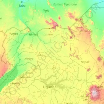
Name: Northern Region topographic map, elevation, terrain.
Location: Northern Region, Uganda (1.36524 30.74007 4.23408 35.00031)
Average elevation: 3,301 ft
Minimum elevation: 1,490 ft
Maximum elevation: 10,121 ft
Other topographic maps
Click on a map to view its topography, its elevation and its terrain.
Nsekwa Musisi
Nsekwa Musisi, Wakiso, Central Region, Uganda
Average elevation: 3,878 ft
Duka
Uganda > Bugisa sub-region > Mbale City
Duka, Mbale City, Bugisa sub-region, Eastern Region, Uganda
Average elevation: 3,714 ft
Bulwandi
Bulwandi, Nakasongola, Central Region, Uganda
Average elevation: 3,504 ft
Ddewe Bwebajja A
Uganda > Central Region > Entebbe City
Ddewe Bwebajja A, Entebbe City, Central Region, Uganda
Average elevation: 3,888 ft
Education
Uganda > Bulambuli > Bugisa sub-region
Education, Bugisa sub-region, Bulambuli, Eastern Region, Uganda
Average elevation: 3,570 ft
Rubaga
Uganda > Central Region > Kampala
Rubaga, Kampala, Central Region, Uganda
Average elevation: 3,894 ft
Kitovu Nume
Uganda > Central Region > Masaka City
Kitovu Nume, Masaka City, Central Region, Uganda
Average elevation: 4,068 ft
Kigoowa I
Uganda > Central Region > Kampala
Kigoowa I, Kampala, Central Region, Uganda
Average elevation: 3,917 ft
Nakawa
Uganda > Central Region > Kampala
Nakawa, Kampala, Central Region, Uganda
Average elevation: 3,865 ft
Ruhaama Central
Ruhaama Central, Ntungamo, Western Region, Uganda
Average elevation: 5,115 ft
Kabazana B
Kabazana B, Kashojwa, Buganza, Isingiro, Western Region, Uganda
Average elevation: 4,180 ft
Senior Quarters 'a'
Senior Quarters 'a', Tororo, Eastern Region, Uganda
Average elevation: 3,930 ft