
河南蒙古族自治县 topographic map
Interactive map
Click on the map to display elevation.
About this map
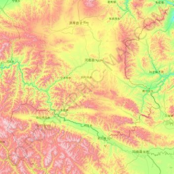
Name: 河南蒙古族自治县 topographic map, elevation, terrain.
Location: 河南蒙古族自治县, 黄南藏族自治州, 青海省, 中国 (33.81346 100.84569 35.21346 102.24569)
Average elevation: 12,405 ft
Minimum elevation: 10,230 ft
Maximum elevation: 15,640 ft
Other topographic maps
Click on a map to view its topography, its elevation and its terrain.