
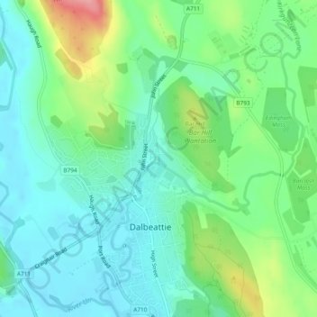
Edingham Burn topographic map
Interactive map
Click on the map to display elevation.
About this map
Name: Edingham Burn topographic map, elevation, terrain.
Average elevation: 115 ft
Minimum elevation: 10 ft
Maximum elevation: 384 ft
Other topographic maps
Click on a map to view its topography, its elevation and its terrain.
Scottish Highlands
United Kingdom > Scotland > Highland
The Scottish Highlands are renowned for their rugged, mountainous terrain that dominates much of the region. Stretching across the northern and central parts of Scotland, the landscape is shaped by ancient geological forces, including the Caledonian Orogeny, which caused significant tectonic collisions…
Average elevation: 2,976 ft
Wigtown
United Kingdom > Scotland > Dumfries and Galloway
Wigtown Castle was in existence by 1291, on flat land down by the River Bladnoch, (outlines clearly seen on an aerial view), whilst the town and church were on a hill, "an inversion of the usual arrangements". Nothing remains of the castle, although a strong natural site and indication of a large enclosed and…
Average elevation: 59 ft
Out Skerries
United Kingdom > Scotland > Shetland
Being so close to Norway, the islands were of strategic importance in World War II and were a regular landfall for Norwegian boats carrying escapees from the Nazi occupation. The local coastguard were responsible for the refugees and at one point during the war were issued with a tommy gun, although initially…
Average elevation: 3 ft
Monifieth
United Kingdom > Scotland > Angus
The name "Monifieth" likely derives from the Gaelic "Moine Feith", "Bogstream of the marsh/moss". Previous suggestions that it comes from "Monadh Fieth" meaning "hill of the deer" make little sense. "Monadh" would mean a large upland mountainous area, which(given that the town is many miles from the highlands)…
Average elevation: 95 ft
Edinburgh
Edinburgh has been popularly called the Athens of the North since the early 19th century. References to Athens, such as Athens of Britain and Modern Athens, had been made as early as the 1760s. The similarities were seen to be topographical but also intellectual. Edinburgh's Castle Rock reminded returning…
Average elevation: 341 ft
Kilmichael of Inverlussa
United Kingdom > Scotland > Argyll and Bute > Achnamara
Average elevation: 325 ft
Dundee
United Kingdom > Scotland > Dundee City
Dundee sits on the north bank of the Firth of Tay on the eastern, North Sea Coast of Scotland. The city lies 36.1 miles (58 km) NNE of Edinburgh and 360.6 miles (580 km) NNW of London. The built-up area occupies a roughly rectangular shape 8.3 miles (13 km) long by 2.5 miles (4 km) wide, aligned in an east to…
Average elevation: 269 ft
Forth and Clyde Canal Glasgow Spur Towpath
United Kingdom > Scotland > Glasgow City > Glasgow
Average elevation: 141 ft
Newtonmore
United Kingdom > Scotland > Highland
Newtonmore is located within the Cairngorms National Park, approximately 3 miles (5 km) southwest of Kingussie and 15 miles (24 km) southwest of Aviemore. It is on the northeastern bank of the River Spey, between the River Calder and the Allt Lairaidh, at an altitude of approximately 250 metres (820 ft).
Average elevation: 928 ft
Àird
United Kingdom > Scotland > Western Isles
There is a dense cluster of lochs across almost the entire island, and almost all of the island is below 20 metres (70 feet) in elevation.
Average elevation: 16 ft
Montrose
United Kingdom > Scotland > Angus
Montrose occupies a position on the North Bank of Montrose Basin at the mouth of the River South Esk on the East Coast of Scotland, 11 miles (18 km) NNE of Arbroath, 19 miles (31 km) SW of Stonehaven, and 7.2 miles (12 km) ESE of Brechin. The town lies 62.2 miles (100 km) NNE of Edinburgh, and 373.2 miles (601…
Average elevation: 72 ft
Braemar
United Kingdom > Scotland > Aberdeenshire
Braemar /breɪˈmɑːr/ (listen) is a village in Aberdeenshire, Scotland, around 58 miles (93 km) west of Aberdeen in the Highlands. It is the closest significantly-sized settlement to the upper course of the River Dee sitting at an elevation of 339 metres (1,112 ft).
Average elevation: 1,460 ft