Geolocate

Porter topographic map

Click on the map to display elevation.

About this map

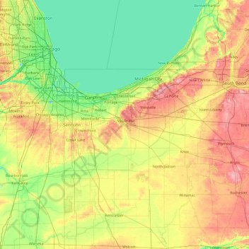
Name: Porter topographic map, elevation, terrain.

Location: Porter, Indiana, 46385, United States (40.74570 -87.77250 42.14570 -86.37250)

Average elevation: 679 ft

Minimum elevation: 561 ft

Maximum elevation: 938 ft

Indiana trails, hiking, mountain biking, running and outdoor activities

Other topographic maps

Click on a map to view its topography, its elevation and its terrain.

Brown County State Park

United States > Indiana > Nashville

Brown County State Park is sometimes called "the Little Smokies" because of similarities with the Smokey Mountains. Activities available in the park include camping, fishing, biking, hiking, and seasonal horseback riding. Many of these activities are available all year. Overnight visitors may stay in the…

Average elevation: 735 ft

Bloomfield

United States > Indiana > Greene County

Average elevation: 551 ft

Marion County

United States > Indiana

Average elevation: 791 ft

Brookston

United States > Indiana > White County

Average elevation: 682 ft

Batesville

United States > Indiana > Ripley County

Average elevation: 965 ft

Porter County

United States > Indiana

Average elevation: 679 ft

Newton County

United States > Indiana

Average elevation: 673 ft

LaGrange County

United States > Indiana

Average elevation: 915 ft

Martin County

United States > Indiana

Average elevation: 591 ft

Owen County

United States > Indiana

Average elevation: 676 ft

DeKalb County

United States > Indiana

Average elevation: 892 ft

St. Joseph

United States > Indiana

Average elevation: 827 ft

Sugar Creek

United States > Indiana

Average elevation: 732 ft

Ohio County

United States > Indiana

Average elevation: 732 ft

White County

United States > Indiana

Average elevation: 689 ft

Miami County

United States > Indiana

Average elevation: 778 ft

Carroll County

United States > Indiana

Average elevation: 689 ft

Daviess County

United States > Indiana

The terrain of Daviess County is hilly, with its area completely devoted to agriculture or urban development. Its highest elevation (740'/266 meters ASL) is a rise one mile (1.6 km) NNE of Farlen. The county is drained by the White River flowing to the southwest, whose two main forks (East White and West…

Average elevation: 505 ft

Pike County

United States > Indiana

Average elevation: 479 ft

Washington

United States > Indiana > Daviess County

Average elevation: 499 ft

Griffith

United States > Indiana > Lake County

Average elevation: 623 ft

Hanover

United States > Indiana > Jefferson County

Average elevation: 748 ft

Lake Monroe

United States > Indiana > Monroe County

Monroe Lake is a reservoir located about 10 miles (16 km) southeast of Bloomington, Indiana, United States. The lake is the largest entirely situated in Indiana with 10,750 acres (43.5 km2) of water surface area spread over the counties of Monroe and Brown. Capacity varies from 292 gigalitres (237,000…

Average elevation: 673 ft

Logansport

United States > Indiana > Cass County

Average elevation: 666 ft

Chalmers

United States > Indiana > White County

Average elevation: 702 ft

Reynolds

United States > Indiana > White County

Average elevation: 692 ft

Rocky Fork Lake

United States > Indiana > Parke County

Average elevation: 728 ft

Clear Creek

United States > Indiana > Monroe County > Clear Creek

Average elevation: 715 ft

Montezuma

United States > Indiana > Parke County

Average elevation: 502 ft

Clear Lake

United States > Indiana > Steuben County

Average elevation: 1,053 ft

Kendallville

United States > Indiana > Noble County

Average elevation: 994 ft

Lowell

United States > Indiana > Lake County

Average elevation: 702 ft

Avilla

United States > Indiana > Noble County

Average elevation: 965 ft

Economy

United States > Indiana > Wayne County

Average elevation: 1,132 ft

Frankton

United States > Indiana > Madison County

Average elevation: 850 ft

Pierceton

United States > Indiana > Kosciusko County

Average elevation: 919 ft

North Judson

United States > Indiana > Starke County

Average elevation: 705 ft

Farmland

United States > Indiana > Randolph County

Average elevation: 1,043 ft

Edgewood

United States > Indiana > Madison County

Average elevation: 876 ft

Fairview Park

United States > Indiana > Vermillion County

Average elevation: 535 ft

Mulberry

United States > Indiana > Clinton County

Average elevation: 778 ft

Oak Park

United States > Indiana > Clark County

Average elevation: 459 ft

Burns Harbor

United States > Indiana > Porter County

Average elevation: 620 ft

Cambridge City

United States > Indiana > Wayne County

Average elevation: 958 ft

Bremen

United States > Indiana > Marshall County

Bremen is located in northeastern Marshall County at 41°26′50″N 86°08′58″W / 41.447109°N 86.149342°W / 41.447109; -86.149342. It is at an elevation of 854 feet (260 m).

Average elevation: 827 ft

Sweetser

United States > Indiana > Grant County

Average elevation: 843 ft

North Salem

United States > Indiana > Hendricks County

Average elevation: 912 ft

Osgood

United States > Indiana > Ripley County

Average elevation: 984 ft

Lynn

United States > Indiana > Randolph County

Average elevation: 1,168 ft

Arcadia

United States > Indiana > Hamilton County

Average elevation: 860 ft

Worthington

United States > Indiana > Greene County

Average elevation: 531 ft

Butler

United States > Indiana > DeKalb County

Average elevation: 869 ft

Dale

United States > Indiana > Spencer County

Average elevation: 453 ft

Greentown

United States > Indiana > Howard County

Average elevation: 846 ft

Grand Calumet River

United States > Indiana > Lake County > Gary

Average elevation: 591 ft

New Washington

United States > Indiana > Clark County

Average elevation: 702 ft

Chandler

United States > Indiana > Warrick County

Average elevation: 423 ft

Yorktown

United States > Indiana > Delaware County

Average elevation: 925 ft

Eaton

United States > Indiana > Delaware County

Average elevation: 915 ft

Albany

United States > Indiana > Delaware County

Average elevation: 951 ft

Chesterfield

United States > Indiana > Madison County

Average elevation: 909 ft

Hamilton

United States > Indiana > Steuben County

Average elevation: 928 ft

Corunna

United States > Indiana > DeKalb County

Average elevation: 968 ft

Altona

United States > Indiana > DeKalb County

Average elevation: 889 ft

Lake Santee

United States > Indiana > Decatur County

Average elevation: 1,007 ft

St. Paul

United States > Indiana > Decatur County

Average elevation: 846 ft

Westport

United States > Indiana > Decatur County

Average elevation: 817 ft

Millhousen

United States > Indiana > Decatur County

Average elevation: 909 ft

New Point

United States > Indiana > Decatur County

Average elevation: 988 ft

Hidden Valley

United States > Indiana > Dearborn County

Average elevation: 702 ft

Saint Leon

United States > Indiana > Dearborn County

Average elevation: 945 ft

Greendale

United States > Indiana > Dearborn County

Average elevation: 551 ft

Boston

United States > Indiana > Wayne County

Average elevation: 1,129 ft

Haw Creek

United States > Indiana > Bartholomew County > Hope

Average elevation: 686 ft

Oldenburg

United States > Indiana > Franklin County

Average elevation: 945 ft

Mount Carmel

United States > Indiana > Franklin County

Average elevation: 1,007 ft

Galena

United States > Indiana > Floyd County

Average elevation: 761 ft

Greenville

United States > Indiana > Floyd County

Average elevation: 804 ft

Glenwood

United States > Indiana > Rush County

Average elevation: 1,089 ft

Parker City

United States > Indiana > Randolph County

According to the 2010 census, Parker City has a total area of 0.57 square miles (1.48 km2), all land. It is located at an elevation of 1025 feet.

Average elevation: 1,024 ft

Wabash

United States > Indiana > Wabash County

Average elevation: 764 ft

Mississinewa River

United States > Indiana > Grant County

Average elevation: 860 ft

Milford

United States > Indiana > Kosciusko County

Average elevation: 837 ft

Kentland

United States > Indiana > Newton County

Average elevation: 679 ft

Haubstadt

United States > Indiana > Gibson County

Average elevation: 463 ft

Jonesboro

United States > Indiana > Grant County

Average elevation: 853 ft

Argos

United States > Indiana > Marshall County

Average elevation: 823 ft

Meridian Hills

United States > Indiana > Marion County

Average elevation: 778 ft

Churubusco

United States > Indiana > Whitley County

Average elevation: 899 ft

New Amsterdam

United States > Indiana > Harrison County

Average elevation: 495 ft

New Middletown

United States > Indiana > Harrison County

Average elevation: 705 ft

Wilkinson

United States > Indiana > Hancock County

Average elevation: 1,007 ft

Spring Lake

United States > Indiana > Hancock County

Average elevation: 850 ft

New Palestine

United States > Indiana > Hancock County

Average elevation: 830 ft

Cumberland

United States > Indiana > Hancock County

Average elevation: 856 ft

Stilesville

United States > Indiana > Hendricks County

Average elevation: 787 ft

Gear up for your next adventure:

🧷Carabiner Set - Durable clips for gear attachment
🪵Folding Camp Saw - Compact saw for wood and campsite work
🎒Gear Packing Cubes - Organize your backpack efficiently
🧢Outdoor Hiking Hat - Sun protection hat for outdoor explorers
🪑Ultralight Camp Chairs - Portable seating for resting after a long day of mapping

As an Amazon Associate, this site earns from qualifying purchases at no extra cost to you.