Geolocate

St. Joseph topographic map

Click on the map to display elevation.

About this map

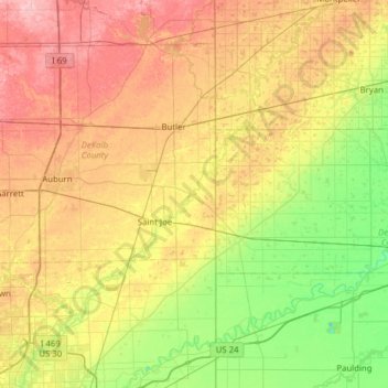
Name: St. Joseph topographic map, elevation, terrain.

Location: St. Joseph, Allen County, Indiana, 46788, United States (41.11414 -85.11625 41.58245 -84.61672)

Average elevation: 827 ft

Minimum elevation: 643 ft

Maximum elevation: 1,076 ft

Indiana trails, hiking, mountain biking, running and outdoor activities

Other topographic maps

Click on a map to view its topography, its elevation and its terrain.

Versailles

United States > Indiana > Ripley County

Average elevation: 938 ft

Marion County

United States > Indiana

Average elevation: 791 ft

Nappanee

United States > Indiana > Elkhart County

Average elevation: 856 ft

Porter County

United States > Indiana

Average elevation: 679 ft

Newton County

United States > Indiana

Average elevation: 673 ft

LaGrange County

United States > Indiana

Average elevation: 915 ft

Martin County

United States > Indiana

Average elevation: 591 ft

DeKalb County

United States > Indiana

Average elevation: 892 ft

Sugar Creek

United States > Indiana

Average elevation: 732 ft

Ohio County

United States > Indiana

Average elevation: 732 ft

Porter

United States > Indiana

Average elevation: 679 ft

White County

United States > Indiana

Average elevation: 689 ft

Miami County

United States > Indiana

Average elevation: 778 ft

Carroll County

United States > Indiana

Average elevation: 689 ft

Daviess County

United States > Indiana

The terrain of Daviess County is hilly, with its area completely devoted to agriculture or urban development. Its highest elevation (740'/266 meters ASL) is a rise one mile (1.6 km) NNE of Farlen. The county is drained by the White River flowing to the southwest, whose two main forks (East White and West…

Average elevation: 505 ft

Pike County

United States > Indiana

Average elevation: 479 ft

Greene

United States > Indiana

Average elevation: 610 ft

Frankton

United States > Indiana > Madison County

Average elevation: 850 ft

Veedersburg

United States > Indiana > Fountain County

Average elevation: 640 ft

Morgantown

United States > Indiana > Morgan County

Average elevation: 686 ft

Frankfort

United States > Indiana > Clinton County

Average elevation: 863 ft

Dooville

United States > Indiana > Grant County > Marion

Average elevation: 863 ft

Indianapolis

United States > Indiana > Indianapolis

Indianapolis is within the Tipton Till Plain, a flat to gently sloping terrain underlain by glacial deposits known as till. The lowest point in the city is about 650 feet (198 m) above mean sea level, with the highest natural elevation at about 900 feet (274 m) above sea level. Few hills or short ridges, known…

Average elevation: 791 ft

Logansport

United States > Indiana > Cass County

Average elevation: 666 ft

Chalmers

United States > Indiana > White County

Average elevation: 702 ft

Reynolds

United States > Indiana > White County

Average elevation: 692 ft

Landersdale

United States > Indiana > Morgan County

Average elevation: 692 ft

Rocky Fork Lake

United States > Indiana > Parke County

Average elevation: 728 ft

Times Corner

United States > Indiana > Allen County > Fort Wayne

Average elevation: 801 ft

Montezuma

United States > Indiana > Parke County

Average elevation: 502 ft

West Newton

United States > Indiana > Marion County > Indianapolis

Average elevation: 748 ft

Clear Lake

United States > Indiana > Steuben County

Average elevation: 1,053 ft

Kendallville

United States > Indiana > Noble County

Average elevation: 994 ft

Newton Stewart

United States > Indiana > Crawford County

Average elevation: 650 ft

Lowell

United States > Indiana > Lake County

Average elevation: 702 ft

Avilla

United States > Indiana > Noble County

Average elevation: 965 ft

Economy

United States > Indiana > Wayne County

Average elevation: 1,132 ft

Brookston

United States > Indiana > White County

Average elevation: 682 ft

Pierceton

United States > Indiana > Kosciusko County

Average elevation: 919 ft

North Judson

United States > Indiana > Starke County

Average elevation: 705 ft

Evansville

United States > Indiana > Vanderburgh County

Average elevation: 413 ft

New Lebanon

United States > Indiana > Sullivan County

Average elevation: 505 ft

Farmland

United States > Indiana > Randolph County

Average elevation: 1,043 ft

Edgewood

United States > Indiana > Madison County

Average elevation: 876 ft

Fairview Park

United States > Indiana > Vermillion County

Average elevation: 535 ft

Mulberry

United States > Indiana > Clinton County

Average elevation: 778 ft

Oak Park

United States > Indiana > Clark County

Average elevation: 459 ft

Burns Harbor

United States > Indiana > Porter County

Average elevation: 620 ft

Cambridge City

United States > Indiana > Wayne County

Average elevation: 958 ft

Bremen

United States > Indiana > Marshall County

Bremen is located in northeastern Marshall County at 41°26′50″N 86°08′58″W / 41.447109°N 86.149342°W / 41.447109; -86.149342. It is at an elevation of 854 feet (260 m).

Average elevation: 827 ft

Inglefield

United States > Indiana > Vanderburgh County

Average elevation: 466 ft

Sweetser

United States > Indiana > Grant County

Average elevation: 843 ft

North Salem

United States > Indiana > Hendricks County

Average elevation: 912 ft

Osgood

United States > Indiana > Ripley County

Average elevation: 984 ft

Lynn

United States > Indiana > Randolph County

Average elevation: 1,168 ft

Arcadia

United States > Indiana > Hamilton County

Average elevation: 860 ft

Worthington

United States > Indiana > Greene County

Average elevation: 531 ft

Butler

United States > Indiana > DeKalb County

Average elevation: 869 ft

Dale

United States > Indiana > Boone County

Average elevation: 955 ft

Dale

United States > Indiana > Spencer County

Average elevation: 453 ft

Greentown

United States > Indiana > Howard County

Average elevation: 846 ft

Boxley

United States > Indiana > Hamilton County

Average elevation: 928 ft

Story

United States > Indiana > Brown County

Average elevation: 640 ft

Taggart

United States > Indiana > Brown County

Average elevation: 778 ft

Trevlac

United States > Indiana > Brown County

Average elevation: 702 ft

Kirkofer Lake Dam

United States > Indiana > Brown County

Average elevation: 791 ft

Spearsville

United States > Indiana > Brown County

Average elevation: 889 ft

Stone Head

United States > Indiana > Brown County

Average elevation: 702 ft

Gnaw Bone

United States > Indiana > Brown County

Average elevation: 758 ft

Lanam

United States > Indiana > Brown County

Average elevation: 794 ft

Mount Liberty

United States > Indiana > Brown County

Average elevation: 791 ft

Needmore

United States > Indiana > Brown County

Average elevation: 732 ft

Peoga

United States > Indiana > Brown County

Average elevation: 919 ft

Pikes Peak

United States > Indiana > Brown County

Average elevation: 719 ft

Gatesville

United States > Indiana > Brown County

Average elevation: 781 ft

Fruitdale

United States > Indiana > Brown County

Average elevation: 810 ft

Christiansburg

United States > Indiana > Brown County

Average elevation: 712 ft

Clarksdale

United States > Indiana > Brown County

Average elevation: 794 ft

Cornelius

United States > Indiana > Brown County

Average elevation: 794 ft

Elkinsville

United States > Indiana > Brown County

Average elevation: 656 ft

Camp Roberts

United States > Indiana > Brown County

Average elevation: 741 ft

Helmsburg

United States > Indiana > Brown County

Average elevation: 728 ft

Becks Grove

United States > Indiana > Brown County

Average elevation: 784 ft

Nabb

United States > Indiana > Clark County

Average elevation: 696 ft

Marysville

United States > Indiana > Clark County

Average elevation: 692 ft

Underwood

United States > Indiana > Clark County

Average elevation: 636 ft

Otisco

United States > Indiana > Clark County

Average elevation: 650 ft

New Washington

United States > Indiana > Clark County

Average elevation: 702 ft

Rolling Hills

United States > Indiana > Clark County

Average elevation: 643 ft

Bethlehem

United States > Indiana > Clark County

Average elevation: 558 ft

Chandler

United States > Indiana > Warrick County

Average elevation: 423 ft

Miller

United States > Indiana > Lake County > Gary

Average elevation: 610 ft

Vistula

United States > Indiana > Elkhart County

Average elevation: 797 ft

Yorktown

United States > Indiana > Delaware County

Average elevation: 925 ft

Cowan

United States > Indiana > Delaware County

Average elevation: 994 ft

Oakville

United States > Indiana > Delaware County

Average elevation: 1,014 ft

Royerton

United States > Indiana > Delaware County

Average elevation: 935 ft

Windsor

United States > Indiana > Randolph County

Average elevation: 1,024 ft

Eaton

United States > Indiana > Delaware County

Average elevation: 915 ft

Gear up for your next adventure:

🪑Ultralight Camp Chairs - Portable seating for resting after a long day of mapping
🛠️Outdoor Gear Repair Kit - Essential tools to fix gear on the trail
📦Dry Bags Set - Waterproof storage for electronics and clothes
🪓Survival Multi‑Tool - Versatile tool for camp and trail tasks
📚USA Hiking Guide Books - Top trail guides and map books

As an Amazon Associate, this site earns from qualifying purchases at no extra cost to you.