Geolocate

DeKalb County topographic map

Click on the map to display elevation.

About this map

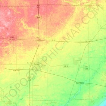
Name: DeKalb County topographic map, elevation, terrain.

Location: DeKalb County, Indiana, United States (41.26428 -85.19408 41.53025 -84.80360)

Average elevation: 892 ft

Minimum elevation: 748 ft

Maximum elevation: 1,053 ft

Indiana trails, hiking, mountain biking, running and outdoor activities

Other topographic maps

Click on a map to view its topography, its elevation and its terrain.

Indianapolis

United States > Indiana > Indianapolis

Indianapolis is within the Tipton Till Plain, a flat to gently sloping terrain underlain by glacial deposits known as till. The lowest point in the city is about 650 feet (198 m) above mean sea level, with the highest natural elevation at about 900 feet (274 m) above sea level. Few hills or short ridges, known…

Average elevation: 791 ft

Floyds Knobs

United States > Indiana > Floyd County

Average elevation: 823 ft

St. Joseph

United States > Indiana

Average elevation: 827 ft

Porter

United States > Indiana

Average elevation: 679 ft

Greene

United States > Indiana

Average elevation: 610 ft

Maplewood

United States > Indiana > Hendricks County

Average elevation: 942 ft

Dooville

United States > Indiana > Grant County > Marion

Average elevation: 863 ft

Landersdale

United States > Indiana > Morgan County

Average elevation: 692 ft

Clear Creek

United States > Indiana > Monroe County > Clear Creek

Average elevation: 715 ft

Times Corner

United States > Indiana > Allen County > Fort Wayne

Average elevation: 801 ft

West Newton

United States > Indiana > Marion County > Indianapolis

Average elevation: 748 ft

Newton Stewart

United States > Indiana > Crawford County

Average elevation: 650 ft

Evansville

United States > Indiana > Vanderburgh County

Average elevation: 413 ft

New Lebanon

United States > Indiana > Sullivan County

Average elevation: 505 ft

Inglefield

United States > Indiana > Vanderburgh County

Average elevation: 466 ft

Dale

United States > Indiana > Boone County

Average elevation: 955 ft

Grand Calumet River

United States > Indiana > Lake County > Gary

Average elevation: 591 ft

Boxley

United States > Indiana > Hamilton County

Average elevation: 928 ft

Story

United States > Indiana > Brown County

Average elevation: 640 ft

Taggart

United States > Indiana > Brown County

Average elevation: 778 ft

Trevlac

United States > Indiana > Brown County

Average elevation: 702 ft

Kirkofer Lake Dam

United States > Indiana > Brown County

Average elevation: 791 ft

Spearsville

United States > Indiana > Brown County

Average elevation: 889 ft

Stone Head

United States > Indiana > Brown County

Average elevation: 702 ft

Gnaw Bone

United States > Indiana > Brown County

Average elevation: 758 ft

Lanam

United States > Indiana > Brown County

Average elevation: 794 ft

Mount Liberty

United States > Indiana > Brown County

Average elevation: 791 ft

Needmore

United States > Indiana > Brown County

Average elevation: 732 ft

Peoga

United States > Indiana > Brown County

Average elevation: 919 ft

Pikes Peak

United States > Indiana > Brown County

Average elevation: 719 ft

Gatesville

United States > Indiana > Brown County

Average elevation: 781 ft

Fruitdale

United States > Indiana > Brown County

Average elevation: 810 ft

Christiansburg

United States > Indiana > Brown County

Average elevation: 712 ft

Clarksdale

United States > Indiana > Brown County

Average elevation: 794 ft

Cornelius

United States > Indiana > Brown County

Average elevation: 794 ft

Elkinsville

United States > Indiana > Brown County

Average elevation: 656 ft

Camp Roberts

United States > Indiana > Brown County

Average elevation: 741 ft

Helmsburg

United States > Indiana > Brown County

Average elevation: 728 ft

Becks Grove

United States > Indiana > Brown County

Average elevation: 784 ft

Nabb

United States > Indiana > Clark County

Average elevation: 696 ft

Marysville

United States > Indiana > Clark County

Average elevation: 692 ft

Underwood

United States > Indiana > Clark County

Average elevation: 636 ft

Otisco

United States > Indiana > Clark County

Average elevation: 650 ft

Rolling Hills

United States > Indiana > Clark County

Average elevation: 643 ft

Bethlehem

United States > Indiana > Clark County

Average elevation: 558 ft

Miller

United States > Indiana > Lake County > Gary

Average elevation: 610 ft

Vistula

United States > Indiana > Elkhart County

Average elevation: 797 ft

Cowan

United States > Indiana > Delaware County

Average elevation: 994 ft

Oakville

United States > Indiana > Delaware County

Average elevation: 1,014 ft

Royerton

United States > Indiana > Delaware County

Average elevation: 935 ft

Windsor

United States > Indiana > Randolph County

Average elevation: 1,024 ft

Spencerville

United States > Indiana > DeKalb County

Average elevation: 817 ft

Milford

United States > Indiana > Decatur County

Average elevation: 846 ft

Saint Omer

United States > Indiana > Decatur County

Average elevation: 873 ft

Sandusky

United States > Indiana > Decatur County

Average elevation: 945 ft

Sardinia

United States > Indiana > Decatur County

Average elevation: 768 ft

Letts

United States > Indiana > Decatur County

Average elevation: 873 ft

Clarksburg

United States > Indiana > Decatur County

Average elevation: 1,053 ft

Lake Santee

United States > Indiana > Decatur County

Average elevation: 1,007 ft

Adams

United States > Indiana > Decatur County

Average elevation: 889 ft

Manchester

United States > Indiana > Dearborn County

Average elevation: 902 ft

Greendale

United States > Indiana > Dearborn County

Average elevation: 551 ft

Haw Creek

United States > Indiana > Bartholomew County > Hope

Average elevation: 686 ft

Scipio

United States > Indiana > Franklin County

Average elevation: 896 ft

Scipio

United States > Indiana > Jennings County

Average elevation: 666 ft

Bath

United States > Indiana > Franklin County

Average elevation: 1,024 ft

Peppertown

United States > Indiana > Franklin County

Average elevation: 925 ft

New Trenton

United States > Indiana > Franklin County

Average elevation: 755 ft

Lake View

United States > Indiana > Franklin County

Average elevation: 988 ft

Hamburg

United States > Indiana > Franklin County

Average elevation: 899 ft

Blooming Grove

United States > Indiana > Franklin County

Average elevation: 981 ft

Andersonville

United States > Indiana > Franklin County

Average elevation: 1,040 ft

Falmouth

United States > Indiana > Rush County

Average elevation: 1,047 ft

Fairview

United States > Indiana > Rush County

Average elevation: 1,056 ft

Everton

United States > Indiana > Fayette County

Average elevation: 997 ft

Southport

United States > Indiana > Marion County > Indianapolis

Average elevation: 774 ft

White Cloud

United States > Indiana > Harrison County

Average elevation: 617 ft

Valley City

United States > Indiana > Harrison County

Average elevation: 653 ft

Tobacco Landing

United States > Indiana > Harrison County

Average elevation: 561 ft

Titus

United States > Indiana > Harrison County

Average elevation: 548 ft

Sugar Grove

United States > Indiana > Harrison County

Average elevation: 561 ft

New Boston

United States > Indiana > Harrison County

Average elevation: 505 ft

Rosewood

United States > Indiana > Harrison County

Average elevation: 525 ft

Glidas

United States > Indiana > Harrison County

Average elevation: 650 ft

Hancock Chapel

United States > Indiana > Harrison County

Average elevation: 768 ft

Moberly

United States > Indiana > Harrison County

Average elevation: 673 ft

Mott Station

United States > Indiana > Harrison County

Average elevation: 702 ft

Fishtown

United States > Indiana > Harrison County

Average elevation: 561 ft

Fairdale

United States > Indiana > Harrison County

Average elevation: 738 ft

Dogwood

United States > Indiana > Harrison County

Average elevation: 646 ft

Evans Landing

United States > Indiana > Harrison County

Average elevation: 525 ft

Gem

United States > Indiana > Hancock County

Average elevation: 856 ft

Milners Corner

United States > Indiana > Hancock County

Average elevation: 928 ft

Mohawk

United States > Indiana > Hancock County

Average elevation: 869 ft

Mount Comfort

United States > Indiana > Hancock County

Average elevation: 860 ft

Nashville

United States > Indiana > Hancock County

Average elevation: 948 ft

Pleasant Acres

United States > Indiana > Hancock County

Average elevation: 860 ft

Riley

United States > Indiana > Hancock County > Greenfield

Average elevation: 902 ft

Gear up for your next adventure:

🪄Magnetic Compass - Accurate compass for navigation
🚑Emergency Bivvies - Heat-reflective sleeping bags for survival situations
🧭Pro Hiking Compasses - High-accuracy liquid-filled compasses for topographic orientation
📱Solar Portable Charger - Solar power bank for charging devices off‑grid
Backpacking Tents - Weight-optimized shelters for multi-day topographic surveys

As an Amazon Associate, this site earns from qualifying purchases at no extra cost to you.