
North America topographic map
Click on the map to display elevation.
North America
North America's topography is characterized by its diverse and dramatic landscapes, stretching from the towering Rocky Mountains in the west to the expansive Great Plains in the central region, and the rugged Appalachian Mountains in the east. The Rocky Mountains, which include peaks exceeding 20,000 feet (6,096 meters), create a formidable spine that bisects the continent and contributes to significant climatic variations across the region. East of the Rockies, the Great Plains—often referred to as the "Breadbasket of North America"—are marked by vast, flat expanses of fertile soil that are ideal for agriculture, ranging from rich grasslands to rolling hills. This area is dotted with numerous rivers, including the Mississippi, which is one of the longest river systems in the world, playing a crucial role in the continent’s drainage and ecosystem. In the northeastern part of North America, the Appalachian Mountains are notable for their ancient, eroded peaks and deep valleys, while the Atlantic Coastal Plain features low-lying wetlands and sandy beaches that support diverse ecosystems. Further north, the Canadian Shield presents a rugged, rocky terrain interspersed with countless lakes formed by glacial activity, illustrating the continent's geological history.
About this map
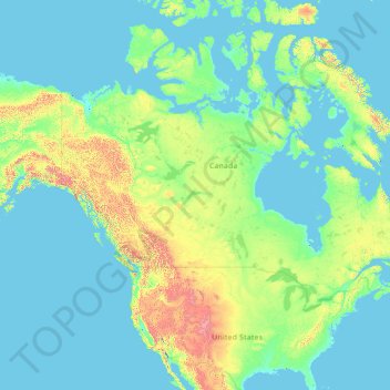
Name: North America topographic map, elevation, terrain.
Location: North America (26.00000 -134.00000 76.00000 -84.00000)
Average elevation: 965 ft
Minimum elevation: -7 ft
Maximum elevation: 19,150 ft
Other topographic maps
Click on a map to view its topography, its elevation and its terrain.
United States
The topography of the United States is characterized by diverse and dynamic landscapes that vary widely across the country. In the east, rolling hills and low mountains transition into the Appalachian Mountains, featuring peaks that generally reach around 6,000 feet (1,829 meters). Moving westward, the terrain…
Average elevation: 1,014 ft
New York
New York City's topography is a fascinating blend of varied elevations and unique landscapes, reflecting its diverse geography across five boroughs. Situated at the confluence of the Hudson and East Rivers, the city primarily features low-lying terrain, with the average elevation hovering around sea level.…
Average elevation: 62 ft
Ohio
Ohio's topography is characterized by a diverse landscape that ranges from the flat plains in the north to the rolling hills and rugged terrain in the southeast. The state can be divided into several distinct regions, including the Great Lakes Plains to the north, the Central Plains in the west, and the…
Average elevation: 912 ft
Seattle
United States > Washington > King County
Seattle features a diverse topography characterized by its unique geographical setting between Puget Sound and Lake Washington. The city is situated on an isthmus, which contributes to its dramatic landscape, featuring rolling hills and steep slopes that rise abruptly from the waterfront. The average elevation…
Average elevation: 131 ft
Arizona
Arizona's topography is highly diverse, shaped by three distinct regions: the Colorado Plateau, the Basin and Range Province, and the Transition Zone. The northern Colorado Plateau is characterized by flat, high plains over 4,000 feet in elevation, including the Grand Canyon and its breathtaking cliffs. In…
Average elevation: 4,032 ft
San Francisco
San Francisco is characterized by its striking and varied topography, making it one of the most distinctive cities in the United States. The landscape features a mix of rolling hills and steep inclines, with the highest elevation reaching approximately 922 feet at Twin Peaks. The average elevation across the…
Average elevation: 213 ft
Manhattan
United States > New York > New York County > New York
Manhattan, a densely populated urban island, has a diverse topography characterized by its generally flat terrain interspersed with elevated areas. The average elevation is about 50 feet (15 meters) above sea level, with its highest point reaching approximately 265 feet (81 meters) at Bennett Park in…
Average elevation: 52 ft
Texas
Texas showcases a diverse and expansive topography that spans approximately 268,000 square miles (694,117 Km²), making it the second-largest state in the United States. The landscape ranges from the arid deserts of West Texas, characterized by broad valleys and mesas, to the rolling hills of the Texas Hill…
Average elevation: 1,699 ft
Pittsburgh
United States > Pennsylvania > Allegheny County
Pittsburgh, located in Allegheny County, Pennsylvania, is characterized by its distinct and varied topography, shaped by the confluence of the Allegheny, Monongahela, and Ohio rivers. The city itself is situated at an average elevation of approximately 764 feet (233 meters) above sea level, with the terrain…
Average elevation: 994 ft
California
California's topography is characterized by a remarkable diversity that includes expansive mountain ranges, deep valleys, and vast deserts. The Sierra Nevada mountains dominate the eastern part of the state, with peaks such as Mount Whitney rising to 14,494 feet (4,418 meters), making it the tallest point in…
Average elevation: 3,048 ft
Austin
United States > Texas > Travis County
Austin features a diverse and varied topography shaped by its position along the Balcones Fault. The city’s elevation ranges from about 425 feet to approximately 1,000 feet above sea level, creating a landscape characterized by rolling hills and elevated areas particularly in the western regions. To the…
Average elevation: 709 ft
Florida
Florida's topography is characterized by its predominantly flat landscape, with the highest elevation being Britton Hill at just 345 feet (105 meters) above sea level, making it the lowest high point of any U.S. state. The state is primarily divided into three physiographic regions: the Atlantic Coastal Plain,…
Average elevation: 20 ft
San Diego
United States > California > San Diego County
San Diego is characterized by a diverse topography that features coastal plains, rolling hills, and rugged mountain ranges. The city is situated along the Pacific Ocean, where it boasts an extensive shoreline with sandy beaches and tidal zones. As you move inland, the landscape transitions from the flat…
Average elevation: 410 ft
Oregon
Oregon's topography is strikingly diverse, characterized by an array of geographical features that shape its unique landscape. The state is framed by two significant mountain ranges: the Pacific Coast Range to the west and the Cascade Mountains running north to south through the center. This mountainous…
Average elevation: 3,077 ft
Denver
United States > Colorado > Denver County > Denver
Denver, situated at an elevation of 5,280 feet (1,609 meters), is renowned as the "Mile High City." It is located in the South Platte River Valley, just east of the Rocky Mountains' foothills. The city's topography features a gently sloping landscape characterized by rolling hills and wide valleys,…
Average elevation: 5,525 ft
Chicago
United States > Illinois > Cook County
Chicago is characterized by its predominantly flat terrain, with an average elevation of about 579 feet (176 meters) above sea level. The city's landscape is primarily shaped by its proximity to Lake Michigan to the east, which influences local weather and provides a scenic waterfront. While the central areas…
Average elevation: 597 ft
Missouri
Missouri's topography is marked by a diverse array of landforms that contribute to its unique landscape. The state is characterized by four main physiographic regions: the Ozark Plateau, Dissected Till Plains, Mississippi Alluvial Plain, and the Osage Plains. The Ozark Plateau, located in the south, features…
Average elevation: 827 ft
Nashville
United States > Tennessee > Davidson County
Nashville-Davidson, features a diverse topography characterized by its position in the Nashville Basin and the Highland Rim. The terrain is predominantly hilly, with elevations ranging from approximately 385 feet at the Cumberland River to around 1,163 feet in areas like Radnor Lake State Natural Area. This…
Average elevation: 604 ft
Portland
United States > Oregon > Multnomah County
Portland features a striking and varied topography characterized by its location at the confluence of the Willamette and Columbia Rivers. The city lies within the fertile Willamette Valley, flanked by the snow-capped Cascade Mountains to the east, including the prominent Mount Hood, and the less elevated…
Average elevation: 253 ft
Georgia
Georgia's topography is notably diverse, characterized by five main geographic regions that each contribute to its unique landscape. The southern part of the state features the Coastal Plain, a flat, low-lying area that gently slopes toward the Atlantic Ocean and is home to the expansive Okefenokee Swamp, one…
Average elevation: 446 ft
Dallas
United States > Texas > Dallas County
Dallas features a predominantly flat terrain characterized by elevations generally ranging from 450 to 550 feet (137 to 168 meters) above sea level. The landscape is shaped significantly by the western edge of the Austin Chalk Formation, a limestone escarpment known as the White Rock Escarpment, which rises…
Average elevation: 525 ft
North Carolina
North Carolina features a diverse topography that can be divided into three distinct regions: the Coastal Plain, the Piedmont, and the Appalachian Mountains. The Coastal Plain, which occupies the eastern part of the state, is characterized by flat and gently sloping land, with elevations typically less than…
Average elevation: 535 ft
Pennsylvania
Pennsylvania's topography is characterized by its rich diversity, ranging from the rugged Appalachian Mountains in the south to the flatlands of the northern plateau. The state's elevation varies significantly, with the highest point being Mount Davis at approximately 3,213 feet (979 meters) and the lowest at…
Average elevation: 1,115 ft
Michigan
Michigan's topography is characterized by a diverse landscape that transitions from flat plains to rugged hills. The state comprises two peninsulas, with the Upper Peninsula showcasing more pronounced elevation changes, including its highest point, Mount Arvon, which rises to 1,979 feet (603 meters). In…
Average elevation: 850 ft
Saint Petersburg
United States > Florida > Pinellas County
Saint Petersburg features a predominantly flat topography characteristic of the Gulf Coast region. The city's elevation averages around 44 feet (approximately 13.4 meters) above sea level, with some areas dipping to about 15 feet (4.6 meters). This relatively low elevation contributes to the area's…
Average elevation: 13 ft
Tennessee
Tennessee features a diverse and varied topography characterized by its distinct regions, which include the Appalachian Mountains, the Central Basin, and the Gulf Coastal Plain. The state’s highest point is Clingmans Dome, rising to about 6,643 feet (2,025 meters) above sea level, while the lowest point is…
Average elevation: 764 ft
Salt Lake City
United States > Utah > Salt Lake County
Salt Lake City's topography is characterized by a striking contrast between its flat valley floor and the surrounding rugged mountains. The city is situated in the Salt Lake Valley, with an average elevation of approximately 4,237 feet above sea level, making it one of the higher major cities in the United…
Average elevation: 5,223 ft
Gatlinburg
United States > Tennessee > Sevier County
Gatlinburg is nestled within the Appalachian Mountains, specifically at the junction of the Ridge-and-Valley and the Blue Ridge provinces, making its topography notably rugged and varied. The town itself sits at an elevation of approximately 1,500 feet above sea level, surrounded by steep ridges and deep…
Average elevation: 1,893 ft
Cincinnati
United States > Ohio > Hamilton County
Cincinnati features a distinctive topography characterized by its rolling hills and valleys. The city is situated on the north bank of the Ohio River, where the terrain rises sharply from the riverfront, reaching elevations of approximately 980 feet (299 meters) in some areas. The average elevation throughout…
Average elevation: 728 ft
Philadelphia
United States > Pennsylvania > Philadelphia County
Philadelphia, located at the confluence of the Delaware and Schuylkill Rivers, features a diverse topography characterized by its gentle slopes and valleys. The city lies on the Atlantic Seaboard Fall Line, transitioning from the flat Coastal Plain to the more rugged Piedmont region. This unique geographical…
Average elevation: 144 ft
Minneapolis
United States > Minnesota > Hennepin County
Minneapolis is characterized by a diverse and dynamic topography. The city sits at an average elevation of approximately 830 feet (253 meters) above sea level, but this varies significantly across its landscape. The terrain is predominantly flat, interspersed with rolling hills, and is marked by the presence…
Average elevation: 886 ft
New Orleans
United States > Louisiana > Orleans Parish
New Orleans is situated on relatively flat terrain, primarily at or slightly below sea level, with the average elevation around 6 feet above sea level. The city's landscape is characterized by a network of wetlands, rivers, and bayous, which play a crucial role in its ecology and urban planning. It lies within…
Average elevation: 3 ft
Virginia
Virginia's topography is characterized by a diverse landscape that transitions from the Atlantic Coastal Plain in the east to the mountainous regions in the west. The Coastal Plain features flat, low-lying areas that gradually rise to the Piedmont, known for its rolling hills and valleys. Further west, the…
Average elevation: 814 ft
Atlanta
United States > Georgia > Fulton County
Atlanta features a varied topography characterized by its rolling hills and elevated terrain. The city sits at an average elevation of approximately 1,050 feet (320 meters) above sea level, with elevations ranging from about 725 feet (221 meters) to 1,175 feet (358 meters) in the surrounding areas. This…
Average elevation: 932 ft
Southern California
Southern California presents a highly varied and tectonically shaped topography, where Pacific coastal plains and urban basins rise abruptly into rugged mountain ranges before descending toward broad inland deserts. Its relief is organized by the east–west Transverse Ranges, including the San Gabriel and San…
Average elevation: 1,900 ft
Iran
Iran's topography is diverse and dominated by rugged mountain ranges, which define much of its landscape. To the west, the Zagros Mountains stretch from the northwest to the southeast, with many peaks surpassing 10,000 feet (3,048 meters) in elevation. These mountains form a rugged barrier between Iran's…
Average elevation: 2,579 ft
Wisconsin
Wisconsin's topography is characterized by a diverse landscape shaped by glacial activity, resulting in a mixture of rolling hills, flat plains, and numerous lakes. The state’s highest point is Timms Hill, reaching an elevation of 1,952 feet (595 meters), while its lowest point is the shore of Lake Michigan…
Average elevation: 988 ft
Houston
United States > Texas > Harris County
Houston is characterized by its predominantly flat topography, sitting at an average elevation of approximately 59 feet (18 meters) above sea level. The city is situated on the Gulf Coastal Plain, which is dissected by a network of bayous that contribute to the region's drainage. This terrain was once covered…
Average elevation: 82 ft
Lake Tahoe
United States > California > Placer County
Lake Tahoe is renowned for its dramatic topography, characterized by rugged mountain ranges and deep, crystal-clear waters. Nestled in the Sierra Nevada, the lake itself lies at an elevation of approximately 6,225 feet (1,897 meters) and spans about 22 miles (35 kilometers) in length and 12 miles (19…
Average elevation: 6,814 ft
Asheville
United States > North Carolina > Buncombe County
Asheville, located in Buncombe County, North Carolina, is characterized by a diverse and picturesque topography primarily shaped by its position within the Blue Ridge Mountains. The city itself sits at an elevation of approximately 2,200 feet, surrounded by peaks that rise significantly higher, such as Mount…
Average elevation: 2,385 ft
Charleston
United States > South Carolina > Charleston County
Charleston is characterized by its relatively flat topography, with an average elevation of about 10 feet above sea level, making it prone to flooding during heavy rains and storms. The city is situated on a peninsula bordered by the Ashley River to the west and the Cooper River to the east, creating a natural…
Average elevation: 13 ft
Kansas City
United States > Missouri > Jackson County
Kansas City features a diverse topography characterized by rolling hills and valleys, with elevations ranging from about 794 to 997 feet above sea level. The landscape is shaped by the confluence of the Missouri and Kansas rivers, resulting in a mix of elevated areas and flat river plains. The region's average…
Average elevation: 909 ft
Oakland
United States > California > Alameda County
Oakland features a diverse topography shaped by its location along the eastern shore of San Francisco Bay and the presence of the nearby coastal hills. The city sits on a flat coastal plain that gradually ascends toward the Oakland Hills to the east, where elevations can exceed 1,700 feet. The highest point…
Average elevation: 167 ft
Alabama
Alabama's topography is characterized by a diverse and intricate landscape that varies significantly across its regions. In the northern and northeastern parts, the terrain features the hilly and mountainous Appalachian Highlands, including the notable Cheaha Mountain, which rises to an elevation of 2,407 feet…
Average elevation: 446 ft
San Antonio
United States > Texas > Bexar County
San Antonio features a diverse topography characterized by gently rolling hills and flat plains. The city's elevation averages around 650 feet above sea level, but nearby areas can reach heights of up to 1,300 feet in certain locations like Cross Mountain. The landscape is part of the southern edge of the…
Average elevation: 810 ft
Kerrville
United States > Texas > Kerr County
Kerrville is characterized by a diverse and rugged topography. Nestled along the Guadalupe River, it sits at an elevation averaging 1,600 feet above sea level, with varying terrain that includes gentle hills, steep slopes, and flat river valleys. This area features numerous limestone hills, characteristic of…
Average elevation: 1,788 ft
Colorado
Colorado's topography is characterized by a diverse range of elevations and landforms, making it one of the most geologically varied states in the U.S. The state is dominated by the Rocky Mountains, which run north to south and include the highest peak in the contiguous United States, Mount Elbert, towering at…
Average elevation: 6,759 ft
Saint Paul
United States > Minnesota > Ramsey County
The year 1858 saw more than 1,000 steamboats service Saint Paul, making it a gateway for settlers to the Minnesota frontier or Dakota Territory. Geography was a primary reason the city became a transportation hub. The location was the last good point to land riverboats coming upriver due to the river valley's…
Average elevation: 879 ft
San Jose
United States > California > Santa Clara County
San Jose, located in Santa Clara County, California, features a diverse topography characterized by a mix of low-lying plains and rolling hills. The city sits at an average elevation of approximately 82 feet (25 meters) above sea level, with the surrounding terrain including the foothills of the Santa Cruz…
Average elevation: 869 ft
Indiana
Indiana's topography is characterized by gently rolling hills, primarily in the central and southern regions, and flat plains in the north. The state's average elevation is around 650 feet, with the highest point being Hoosier Hill at approximately 1,257 feet, located in Wayne County. The lowest elevation,…
Average elevation: 741 ft
Orlando
United States > Florida > Orange County
Orlando features a predominantly flat terrain characterized by gentle hills and low-lying areas, with elevations typically ranging from 50 to 100 feet above sea level. Despite its overall flatness, the topography includes marshes and wetlands due to the presence of numerous lakes and rivers, contributing to a…
Average elevation: 95 ft
Oʻahu
United States > Hawaii > Honolulu County
Oʻahu exhibits a striking and diverse topography shaped primarily by its volcanic origins and subsequent erosion. The island features a rugged landscape dominated by two prominent volcanic mountains, Koʻolau and Waiʻanae, which rise sharply from the coastline, reaching elevations of approximately 4,000…
Average elevation: 259 ft
Omaha
United States > Nebraska > Douglas County
Omaha features a varied topography characterized by rolling hills and valleys that rise gently from the Missouri River, which forms the city's eastern boundary. The landscape is primarily composed of prairie and hardwood forests, offering a mix of open spaces and wooded areas. Elevations within the city range…
Average elevation: 1,109 ft
Louisiana
Louisiana's topography is defined by a variety of landscapes that reflect both its coastal and inland characteristics. Much of the state consists of low-lying plains, including the Mississippi Alluvial Plain, where the fertile soils of the delta create an area vital for agriculture. The eastern region near the…
Average elevation: 128 ft
Albuquerque
United States > New Mexico > Bernalillo County
Albuquerque features a striking topography characterized by its elevation and diverse geological formations. The city sits at an approximate elevation of 4,900 feet (1,500 meters) near the Rio Grande, rising dramatically to over 6,700 feet (2,000 meters) in the foothills of the nearby Sandia Mountains. These…
Average elevation: 5,535 ft
Wyoming
Wyoming's topography is characterized by a dramatic and varied landscape that includes vast mountain ranges, expansive plateaus, and intermontane basins. The state is predominantly mountainous, with the Rocky Mountains covering a significant portion of its western region. Here, the Wind River Range rises to…
Average elevation: 6,358 ft
Reno
United States > Nevada > Washoe County
Reno is characterized by its diverse topography, which is shaped by its elevation and the surrounding mountain ranges. Situated at an average elevation of approximately 4,500 feet (about 1,370 meters), the city is nestled in a high desert region that features a mix of flat valleys and gently rolling hills.…
Average elevation: 5,413 ft
Las Vegas
United States > Nevada > Clark County
Las Vegas is characterized by its distinctive topography, which features a mix of arid desert landscapes and mountainous terrain. The city itself sits at an elevation of approximately 2,030 feet (620 meters) above sea level, while the surrounding peaks reach heights exceeding 10,000 feet (3,000 meters),…
Average elevation: 2,516 ft
Adirondack Park
Adirondack Park, covering over six million acres, features a diverse topography characterized by rugged mountains, extensive forests, and numerous waterways. The park is dominated by the Adirondack Mountains, which contain 46 peaks exceeding 4,000 feet, with Mount Marcy standing at 5,343 feet as the highest…
Average elevation: 1,217 ft
Mexico
Mexico's topography is characterized by a remarkable diversity, featuring rugged mountains, expansive plateaus, and lush coastal plains. The Sierra Madre Occidental and Sierra Madre Oriental mountain ranges run parallel to the country's western and eastern coasts, respectively, creating a central highland…
Average elevation: 1,352 ft
Bend
United States > Oregon > Deschutes County
Bend is characterized by its distinctive topography, situated at an elevation of approximately 3,623 feet (1,105 meters) above sea level. The city lies within the high desert region of Central Oregon, bordered by the Cascade Mountains to the west, which provide a dramatic backdrop with peaks like the Three…
Average elevation: 3,678 ft
Los Angeles
United States > California > Los Angeles County
Los Angeles is characterized by a diverse and dynamic topography. The city is predominantly situated in a basin bordered by mountain ranges, including the Santa Monica Mountains to the north and the San Gabriel Mountains to the east, with elevations reaching up to about 10,000 feet (3,048 meters) in certain…
Average elevation: 791 ft
South Carolina
South Carolina's topography is defined by three major geographic regions: the Atlantic Coastal Plain, the Piedmont, and the Blue Ridge Mountains. Covering approximately two-thirds of the state, the Atlantic Coastal Plain is characterized by flat, gently rolling terrain that transitions from the sandy beaches…
Average elevation: 279 ft
New Mexico
New Mexico's topography is strikingly diverse, characterized by a mix of high mountain ranges, arid plains, and expansive desert regions. The state is primarily defined by the Rocky Mountains, which run north to south through its central region, featuring peaks that reach over 13,000 feet, such as Wheeler…
Average elevation: 5,535 ft
Wilmington
United States > North Carolina > New Hanover County
Wilmington sits near the southeastern coast and has a low-lying, relatively flat topography with an average elevation around 36 feet above sea level. The terrain is characterized by coastal plains with minimal elevation changes, making the landscape generally flat as it gently slopes toward the Atlantic Ocean.…
Average elevation: 23 ft
Yellowstone National Park
Yellowstone National Park's topography is characterized by a remarkable diversity of geological features shaped by its unique volcanic history and tectonic activity. The park is predominantly situated on the Yellowstone Plateau, which is part of the larger Rocky Mountain range, with elevations ranging from…
Average elevation: 8,038 ft
Phoenix
United States > Arizona > Maricopa County
Phoenix is characterized by a unique topographical landscape nestled in the Salt River Valley. This valley, at an average elevation of about 1,086 feet, is framed by several prominent mountain ranges, creating a striking contrast between the flat plains and elevated terrains. Notable peaks such as Camelback…
Average elevation: 1,578 ft
Charlotte
United States > North Carolina > Mecklenburg County
Charlotte, located in the Piedmont region of North Carolina, features a gently rolling terrain characterized by elevations ranging from approximately 650 to 700 feet (198 to 213 meters). The city is bordered to the west by the Catawba River, which contributes to the area's mild climate and lush vegetation.…
Average elevation: 679 ft
Savannah
United States > Georgia > Chatham County
Savannah is characterized by a unique and varied topography shaped by its coastal location and historical development. The city is situated on a series of low bluffs along the Savannah River, which flows into the Atlantic Ocean approximately 18 miles (29 km) away. The terrain features a mix of flat coastal…
Average elevation: 13 ft
Kentucky
Kentucky's topography is characterized by a diverse landscape that varies significantly across its regions. The state features rolling hills, plateaus, and mountainous areas, particularly in the eastern section where the Cumberland Plateau rises to the highest point at Black Mountain, which reaches 4,139 feet…
Average elevation: 991 ft
El Paso
United States > Texas > El Paso County
El Paso is characterized by a diverse and striking topography shaped by its desert environment and mountainous landscapes. The city is situated at an average elevation of approximately 3,700 feet above sea level, surrounded by the rugged Franklin Mountains to the west, where peaks exceed 7,000 feet. This…
Average elevation: 4,058 ft
Branson
United States > Missouri > Taney County
Branson features a diverse and picturesque topography characterized by rolling hills, deep valleys, and abundant water features. Nestled in the Ozark Mountains, the area has an elevation that typically ranges around 778 feet (237 meters) above sea level. The region is shaped by its proximity to several lakes,…
Average elevation: 902 ft
Chattanooga
United States > Tennessee > Hamilton County
Chattanooga showcases a diverse and striking topography that is defined by its position within the Appalachian region. Nestled between the rugged Ridge-and-Valley Appalachians and the Cumberland Plateau, the city is framed by dramatic hills and valleys, creating a visually compelling landscape. The Tennessee…
Average elevation: 1,086 ft
Mexico City
Mexico City is situated in the Valley of Mexico, an expansive highland region characterized by a unique and varied topography. The city itself rests at an elevation of approximately 7,350 feet (2,240 meters) above sea level, surrounded by formidable mountain ranges, including the Sierra de Guadalupe to the…
Average elevation: 8,593 ft
Pinellas County
Pinellas County features a predominantly flat terrain, characterized by low-lying coastal plains that rise gently from the shores of the Gulf of Mexico. The highest points in the county reach around 60 feet above sea level, primarily found in the northern sections. The area is interspersed with numerous water…
Average elevation: 13 ft
Cleveland
United States > Ohio > Cuyahoga County
Cleveland features a diverse topography shaped significantly by its proximity to Lake Erie and the Cuyahoga River. The city is characterized by a rapid elevation change, with the lakefront sitting at approximately 569 feet above sea level. Just inland, Public Square rises to about 650 feet, while further from…
Average elevation: 705 ft
Long Island
Long Island’s topography is a low, elongated glacial landscape, shaped less by bedrock relief than by the deposits left at the southern margin of the last ice sheets. Its main relief is organized around two broad terminal-moraine belts—the Harbor Hill moraine along much of the North Shore and the…
Average elevation: 138 ft
Washington
Washington State's topography is characterized by dramatic contrasts, shaped primarily by the formidable Cascade Mountain Range that divides the state into distinct western and eastern regions. The western part is marked by rugged mountains, lush forests, and a plethora of lakes, resulting from glacial…
Average elevation: 2,612 ft
Colorado Springs
United States > Colorado > El Paso County
Colorado Springs boasts a diverse and striking topography characterized by its high elevation and mountainous terrain. Nestled at approximately 6,035 feet (1,839 meters) above sea level, the city is flanked by the majestic Pikes Peak, which rises dramatically to 14,115 feet (4,302 meters), forming part of the…
Average elevation: 7,388 ft
Prescott Valley
United States of America > Arizona > Prescott Valley
Prescott Valley (locally, PV) is located in central Arizona approximately 85 miles (137 km) north of Phoenix at 5,100 feet (1,600 m). elevation. PV has good access to Arizona State Route 89, SR-89A and SR-69, connecting to Interstates 17 and 40. Air service is available at Ernest A. Love Field, about 8 miles…
Average elevation: 5,085 ft
Scottsdale
United States > Arizona > Maricopa County
Scottsdale features a diverse topography shaped by its location within the Sonoran Desert and the foothills of the McDowell Mountains. The city sits at an average elevation of about 1,827 feet (558 meters), with a range that spans from approximately 1,052 feet (321 meters) at its lowest points to 4,819 feet…
Average elevation: 1,814 ft
Raleigh
United States > North Carolina > Wake County
Raleigh features a topography primarily defined by its position along the fall line, which is the geological boundary between the Piedmont and Coastal Plain regions. This area experiences a gradual elevation drop of approximately 150 to 350 feet over a distance of 1 to 3 miles as one moves eastward. The city's…
Average elevation: 338 ft
Alaska
Alaska's topography is characterized by dramatic contrasts, featuring a diverse array of mountainous regions, vast plains, and intricate coastlines. The Alaska Range, home to Denali, rises to an elevation of 20,310 feet, making it the highest peak in North America. This mountain range exhibits significant…
Average elevation: 679 ft
Mississippi
Mississippi's topography is characterized by its low-lying terrain, predominantly shaped by river systems and geological formations. The state features a variety of landscapes, including the expansive Mississippi Alluvial Plain, which forms the fertile heart of the Delta region. This area is characterized by…
Average elevation: 243 ft
Arkansas
Arkansas, often referred to as the "Natural State," features a diverse topography characterized by rolling hills, extensive forests, and significant river valleys. The landscape is primarily shaped by two major mountain ranges: the Ozark Mountains in the north and the Ouachita Mountains to the south. The…
Average elevation: 512 ft
Greenville
United States > South Carolina > Greenville County
Greenville features a varied topography characterized by rolling hills and the nearby Blue Ridge Mountains. The city sits at an elevation of approximately 984 feet (300 meters) above sea level, with its landscape shaped significantly by the Reedy River, which flows through the heart of downtown, creating…
Average elevation: 951 ft
Huntsville
United States > Alabama > Madison County
Huntsville lies in the Tennessee Valley, where broad lowlands meet the western escarpments and outliers of the Cumberland Plateau. The city’s central and western areas occupy relatively flat to gently rolling valley terrain, while the eastern and southeastern skyline rises abruptly toward Monte Sano, Green…
Average elevation: 761 ft
Amarillo
United States > Texas > Potter County
Amarillo features a unique topography characterized by its high elevation and flat plains. The city averages around 3,600 feet (1,097 meters) above sea level, making it one of the highest major cities in Texas. The surrounding landscape consists of the Llano Estacado, a vast tabletop plateau that slopes…
Average elevation: 3,602 ft
West Virginia
West Virginia is renowned for its mountainous terrain, primarily part of the Appalachian Mountain system. The state's topography is characterized by steep ridges, deep valleys, and rugged plateaus. The Allegheny Plateau dominates much of the western and central regions, with its dissected hills and valleys,…
Average elevation: 1,411 ft
Birmingham
United States > Alabama > Jefferson County
Birmingham has a varied and rugged topography shaped by the nearby Appalachian foothills. The city sits at an average elevation of around 600 feet (183 meters), though it is surrounded by more dramatic terrain that rises higher to 1,000 feet (305 meters) in some areas, particularly to the south and east.…
Average elevation: 633 ft
Connecticut
Connecticut's topography is a diverse landscape characterized by a mix of mountainous regions, lowlands, and coastal areas. The state can be broadly divided into five geographical regions: the Taconic Section, which features the highest point in Connecticut at Bear Mountain (2,380 feet / 725 meters), has steep…
Average elevation: 387 ft
Fayetteville
United States > Arkansas > Washington County
Fayetteville is nestled in the picturesque Ozark Mountains, characterized by rolling hills, lush forests, and scenic valleys that define the region's topography. The elevation in Fayetteville ranges from about 1,100 feet to over 1,500 feet above sea level, creating a varied landscape that features steep ridges…
Average elevation: 1,316 ft
Baja California
Baja California is the 12th-largest state by area in Mexico. Its geography ranges from beaches to forests and deserts. The backbone of the state is the Sierra de Baja California, where Picacho del Diablo, the highest point of the peninsula, is located. This mountain range effectively divides the weather…
Average elevation: 587 ft
Jersey City
United States > New Jersey > Hudson County
Jersey City has a varied topography shaped by its coastal and urban setting along the lower Hudson River. This area, largely at low elevation, sits mostly around 20 feet above sea level, with extensive flatlands near the riverbanks but modest rises inland, leading to subtle hills within the city's dense urban…
Average elevation: 30 ft
Flagstaff
United States > Arizona > Coconino County
Flagstaff, located in Coconino County, Arizona, is characterized by its diverse topography, primarily shaped by its high elevation and volcanic activity. Sitting at around 7,000 feet (approximately 2,130 meters), the city is surrounded by the expansive Coconino National Forest, which features a blend of…
Average elevation: 7,139 ft
Fairbanks
United States > Alaska > Fairbanks North Star
Fairbanks is situated within the central Tanana Valley, characterized by a diverse and dynamic topography. The city straddles the Chena River, which flows southwest into the larger Tanana River, defining Fairbanks' southern border. To the north, a gradual incline leads into a chain of hills that ascend toward…
Average elevation: 479 ft
Maryland
Maryland's topography is notably diverse, characterized by distinct geographic regions that showcase a variety of landscapes. The state can be divided into three major landforms: the Coastal Plain, the Piedmont, and the Appalachian region, which includes the Blue Ridge and Allegheny Mountains. The Coastal…
Average elevation: 489 ft