
Make a donation
Gear up for your next adventure:
As an Amazon Associate, this site earns from qualifying purchases at no extra cost to you.
太龙镇 topographic map
Click on the map to display elevation.
Make a donation
Gear up for your next adventure:
As an Amazon Associate, this site earns from qualifying purchases at no extra cost to you.
About this map
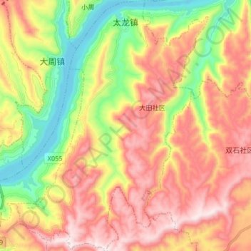
Name: 太龙镇 topographic map, elevation, terrain.
Location: 太龙镇, 万州区, 重庆市, 中国 (30.80211 108.47848 30.91521 108.57961)
Average elevation: 1,486 ft
Minimum elevation: 299 ft
Maximum elevation: 2,657 ft
Make a donation
Gear up for your next adventure:
As an Amazon Associate, this site earns from qualifying purchases at no extra cost to you.
Other topographic maps
Click on a map to view its topography, its elevation and its terrain.
Make a donation
Gear up for your next adventure:
As an Amazon Associate, this site earns from qualifying purchases at no extra cost to you.
永川区
城区公交线路31条,公交车331辆,大部分车型为电气混动或纯电动,主要车型品牌为恒通、宇通,区内发行的永川区智能公交卡与重庆宜居畅通卡可在对方运营区域内的公共交通上互刷使用;区内出租车1216辆,车型为黄色和深蓝色相间涂装的天然气动力长安铃木轿车。滴滴出行在永川区设有运营机构。百度在永川区设有西部自动驾驶开放测试和示范运营基地,并于2022年5月获准在永川城区部分路段开始进行“方向盘后无人”自动驾驶测试,2022年8月正式开始运营自动驾驶网约车。2021年,全区机动车保有量为22.56万辆,由于城区地形较平坦,电动自行车亦为市民主要的通勤工具,摩托车则在乡村地区广受欢迎。
Average elevation: 1,201 ft
Make a donation
Gear up for your next adventure:
As an Amazon Associate, this site earns from qualifying purchases at no extra cost to you.
Make a donation
Gear up for your next adventure:
As an Amazon Associate, this site earns from qualifying purchases at no extra cost to you.
Make a donation
Gear up for your next adventure:
As an Amazon Associate, this site earns from qualifying purchases at no extra cost to you.
Make a donation
Gear up for your next adventure:
As an Amazon Associate, this site earns from qualifying purchases at no extra cost to you.
Make a donation
Gear up for your next adventure:
As an Amazon Associate, this site earns from qualifying purchases at no extra cost to you.
Make a donation
Gear up for your next adventure:
As an Amazon Associate, this site earns from qualifying purchases at no extra cost to you.
Make a donation
Gear up for your next adventure:
As an Amazon Associate, this site earns from qualifying purchases at no extra cost to you.
江津区
江津位于长江中上游,三峡库区尾端。地处东经105°49′—106°38′,北纬28°28′—29°28′之间,东西宽80公里,南北长100公里。地形南高北低,以丘陵兼低山地貌为主,分平阶地、丘陵地和山地,其中丘陵占78.2%,低中山占21.8%。南部四面山区系云贵高原过渡到四川盆地的梯形地带,北部华盖山等系华莹山支脉。海拔最高处四面山蜈蚣坝为1709.4米,最低处珞璜镇中坝为178.5米,相对高差为1530.9米。坝有中坝、稿子坝、几江坝、德感坝、柳林坝、苟洲坝等,坪有圣灯坪、鹤山坪、金紫坪、高家坪、登云坪、篆山坪等。 长江流经北部横贯东西,支流有綦江、塘河、津璧河、笋溪河、朱杨溪、驴子溪、清溪河、梅江河大小河流3…
Average elevation: 1,007 ft
Make a donation
Gear up for your next adventure:
As an Amazon Associate, this site earns from qualifying purchases at no extra cost to you.
Make a donation
Gear up for your next adventure:
As an Amazon Associate, this site earns from qualifying purchases at no extra cost to you.
Make a donation
Gear up for your next adventure:
As an Amazon Associate, this site earns from qualifying purchases at no extra cost to you.
Make a donation
Gear up for your next adventure:
As an Amazon Associate, this site earns from qualifying purchases at no extra cost to you.
Make a donation
Gear up for your next adventure:
As an Amazon Associate, this site earns from qualifying purchases at no extra cost to you.
Make a donation
Gear up for your next adventure:
As an Amazon Associate, this site earns from qualifying purchases at no extra cost to you.
Make a donation
Gear up for your next adventure:
As an Amazon Associate, this site earns from qualifying purchases at no extra cost to you.
Make a donation
Gear up for your next adventure:
As an Amazon Associate, this site earns from qualifying purchases at no extra cost to you.
Make a donation
Gear up for your next adventure:
As an Amazon Associate, this site earns from qualifying purchases at no extra cost to you.
Make a donation
Gear up for your next adventure:
As an Amazon Associate, this site earns from qualifying purchases at no extra cost to you.
Make a donation
Gear up for your next adventure:
As an Amazon Associate, this site earns from qualifying purchases at no extra cost to you.
Make a donation
Gear up for your next adventure:
As an Amazon Associate, this site earns from qualifying purchases at no extra cost to you.
Make a donation
Gear up for your next adventure:
As an Amazon Associate, this site earns from qualifying purchases at no extra cost to you.
Make a donation
Gear up for your next adventure:
As an Amazon Associate, this site earns from qualifying purchases at no extra cost to you.
Make a donation
Gear up for your next adventure:
As an Amazon Associate, this site earns from qualifying purchases at no extra cost to you.
Make a donation
Gear up for your next adventure:
As an Amazon Associate, this site earns from qualifying purchases at no extra cost to you.
Make a donation
Gear up for your next adventure:
As an Amazon Associate, this site earns from qualifying purchases at no extra cost to you.