
Wayne County topographic map
Interactive map
Click on the map to display elevation.
About this map
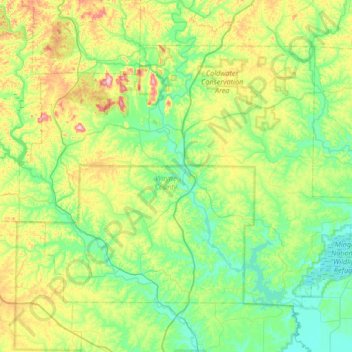
Name: Wayne County topographic map, elevation, terrain.
Location: Wayne County, Missouri, United States (36.92142 -90.77971 37.31749 -90.11046)
Average elevation: 597 ft
Minimum elevation: 315 ft
Maximum elevation: 1,411 ft
Missouri trails, hiking, mountain biking, running and outdoor activities
Other topographic maps
Click on a map to view its topography, its elevation and its terrain.
The Lead Belt
United States > Missouri > Saint Francois County > Bonne Terre
Average elevation: 843 ft
Richard L. Berkley Riverfront Park
United States > Missouri > Jackson County > Kansas City
Average elevation: 794 ft
Mississippi & Missouri River Confluence Point
United States > Missouri > Saint Charles County > West Alton
Average elevation: 413 ft
Iron County
Taum Sauk Mountain /ˈtɔːm ˈsɔːk/ in the Saint Francois Mountains is the highest natural point in the U.S. state of Missouri at 1,772 feet (540 m). The topography of Taum Sauk is that of an elongated ridge with a NNW-SSE orientation rather than a peak.
Average elevation: 1,529 ft