
白涛街道 topographic map
Interactive map
Click on the map to display elevation.
About this map
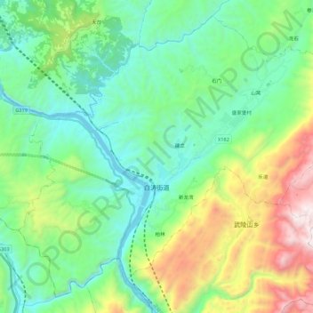
Name: 白涛街道 topographic map, elevation, terrain.
Location: 白涛街道, 涪陵区, 重庆市, 中国 (29.48586 107.40084 29.65661 107.61860)
Average elevation: 2,067 ft
Minimum elevation: 446 ft
Maximum elevation: 6,388 ft
Other topographic maps
Click on a map to view its topography, its elevation and its terrain.