
响水镇 topographic map
Interactive map
Click on the map to display elevation.
About this map
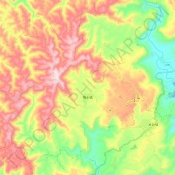
Name: 响水镇 topographic map, elevation, terrain.
Location: 响水镇, 万州区, 重庆市, 中国 (30.61866 108.10934 30.70280 108.22565)
Average elevation: 1,867 ft
Minimum elevation: 971 ft
Maximum elevation: 2,717 ft
镇政府驻地响水滩距万州主城区西南24.5公里,面积30.2平方公里,海拔520米。全镇地属丘陵,西北高、东南低,最高处响水镇錾子垭山峰,海拔802米;最低处岩口乡滥金沟,海拔300米,以红石骨子土和棕黄色粘土为主。年平均气温15℃,最高气温37℃(七月),最低温度-4摄氏度(一月)。年降水量1200毫米,无霜期280天左右。水库29座,山平塘1985口,河水堰5条其他水利设施35处,耕地面积4.95万亩。主产水稻、玉米、薯类、小麦、油菜籽等,特产蚕茧、油桐等。
Other topographic maps
Click on a map to view its topography, its elevation and its terrain.