Geolocate

Hytop topographic map

Click on the map to display elevation.

About this map

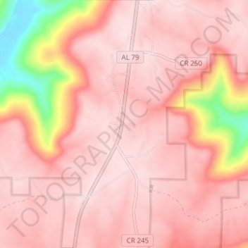
Name: Hytop topographic map, elevation, terrain.

Location: Hytop, Jackson County, Alabama, United States (34.88095 -86.10049 34.93160 -86.07439)

Average elevation: 1,542 ft

Minimum elevation: 673 ft

Maximum elevation: 1,791 ft

Alabama trails, hiking, mountain biking, running and outdoor activities

Other topographic maps

Click on a map to view its topography, its elevation and its terrain.

Cook Springs

United States > Alabama > St. Clair County

Average elevation: 728 ft

Camp Comer Dam

United States > Alabama > DeKalb County

Average elevation: 1,608 ft

Marion County

United States > Alabama

Average elevation: 650 ft

Lawrence County

United States > Alabama

Average elevation: 673 ft

Coffee County

United States > Alabama

Average elevation: 308 ft

Henagar

United States > Alabama > DeKalb County

Average elevation: 1,430 ft

Point Clear

United States > Alabama > Baldwin County

Average elevation: 33 ft

Hokes Bluff

United States > Alabama > Etowah County

Average elevation: 614 ft

Five Points

United States > Alabama > Chambers County

Average elevation: 827 ft

Lay lake

United States > Alabama > Shelby County

Average elevation: 492 ft

Boaz

United States > Alabama > Marshall County

Average elevation: 1,053 ft

Clarke County

United States > Alabama

Average elevation: 171 ft

Mobile Bay

United States > Alabama > Mobile County

Average elevation: 39 ft

Fayette County

United States > Alabama

Average elevation: 476 ft

W P McLean Dam Number 1

United States > Alabama

Average elevation: 180 ft

Franklin County

United States > Alabama

Average elevation: 728 ft

Montgomery County

United States > Alabama

Average elevation: 285 ft

Russell County

United States > Alabama

Average elevation: 354 ft

Perry County

United States > Alabama

Average elevation: 253 ft

Lowndes County

United States > Alabama

Average elevation: 246 ft

Dallas County

United States > Alabama

Average elevation: 226 ft

Lamar County

United States > Alabama

Average elevation: 394 ft

Macon County

United States > Alabama

Average elevation: 397 ft

Pickens County

United States > Alabama

Less than one-third of the county was developed for cotton plantations, which were worked by enslaved African-Americans brought south by northern businessmen interested in cheap cotton. These plantations were developed primarily in the southernmost reaches of the county, in the lowlands along the banks of the…

Average elevation: 256 ft

Wilcox County

United States > Alabama

Average elevation: 197 ft

Sumter County

United States > Alabama

Average elevation: 187 ft

Butler County

United States > Alabama

Average elevation: 344 ft

Bluff Park

United States > Alabama > Jefferson County > Hoover

Average elevation: 810 ft

Ono Island

United States > Alabama > Baldwin County

Ono Island was along the boundary of the treaties between France and Spain. In 1813, after protests and attempts at rebellion, President James Monroe seized Spanish lands west of the Perdido River and declared them a part of the Louisiana Purchase of 1803. This set the east end of the Island, Perdido Key, at…

Average elevation: 30 ft

Gardendale

United States > Alabama > Jefferson County

Average elevation: 591 ft

Eufaula

United States > Alabama > Barbour County > Eufaula > Eufaula

Average elevation: 253 ft

McCalla

United States > Alabama > Jefferson County

Average elevation: 571 ft

Carrville

United States > Alabama > Tallapoosa County > Tallassee

Average elevation: 367 ft

Adger

United States > Alabama > Jefferson County

Average elevation: 502 ft

Cloverland

United States > Alabama > Montgomery County > Montgomery

Average elevation: 220 ft

Powell

United States > Alabama > DeKalb County

Average elevation: 1,250 ft

Elm Bluff

United States > Alabama > Dallas County

Average elevation: 289 ft

Old Bingham

United States > Alabama > Elmore County

Average elevation: 203 ft

East Irondale

United States > Alabama > Jefferson County > Irondale

Average elevation: 833 ft

Guin

United States > Alabama > Marion County

Average elevation: 551 ft

Georgiana

United States > Alabama > Butler County

Average elevation: 279 ft

Harpersville

United States > Alabama > Shelby County

Average elevation: 456 ft

Holt

United States > Alabama > Tuscaloosa County > Elm Ridge

Average elevation: 289 ft

Mignon

United States > Alabama > Talladega County

Average elevation: 564 ft

Carrollton

United States > Alabama > Pickens County

Average elevation: 236 ft

Blue Ridge

United States > Alabama > Elmore County

Average elevation: 289 ft

Lawley

United States > Alabama > Bibb County

Average elevation: 456 ft

New Brockton

United States > Alabama > Coffee County

Average elevation: 400 ft

Taylor

United States > Alabama > Houston County

Average elevation: 289 ft

Dolomite

United States > Alabama > Jefferson County > Birmingham

Average elevation: 577 ft

Vincent

United States > Alabama > Shelby County

Average elevation: 482 ft

Hazel Green

United States > Alabama > Madison County

Average elevation: 791 ft

Rehobeth

United States > Alabama > Houston County

Average elevation: 246 ft

West Ridge

United States > Alabama > Jefferson County > Trussville

Average elevation: 971 ft

Sky Ball

United States > Alabama > Blount County

Average elevation: 906 ft

Danzler

United States > Alabama > Blount County

Average elevation: 666 ft

Brooksville

United States > Alabama > Blount County

Average elevation: 846 ft

Little Warrior

United States > Alabama > Blount County

Average elevation: 591 ft

Blount Springs

United States > Alabama > Blount County

Average elevation: 591 ft

Bangor

United States > Alabama > Blount County

Average elevation: 633 ft

Trafford

United States > Alabama > Jefferson County

Average elevation: 479 ft

Snead

United States > Alabama > Blount County

Average elevation: 781 ft

Rosa

United States > Alabama > Blount County

Average elevation: 768 ft

Nectar

United States > Alabama > Blount County

Average elevation: 584 ft

Highland Lake

United States > Alabama > Blount County

Highland Lake is located in eastern Blount County at 33°53'3.376" North, 86°25'19.744" West (33.884271, -86.422151). The town consists of homes built around Highland Lake, a reservoir on the Blackburn Fork of the Little Warrior River. The lake, at an elevation of 895 feet (273 m) above sea level, is in a…

Average elevation: 981 ft

Garden City

United States > Alabama > Cullman County

Average elevation: 581 ft

County Line

United States > Alabama > Blount County

Average elevation: 495 ft

Cleveland

United States > Alabama > Blount County

Average elevation: 607 ft

Allgood

United States > Alabama > Blount County

Average elevation: 853 ft

Goodwater

United States > Alabama > Coosa County

Average elevation: 823 ft

Belgreen

United States > Alabama > Franklin County

Average elevation: 768 ft

Cowarts

United States > Alabama > Houston County

Average elevation: 272 ft

Vina

United States > Alabama > Franklin County

Average elevation: 692 ft

Vinemont

United States > Alabama > Cullman County > South Vinemont

Average elevation: 948 ft

Logan

United States > Alabama > Cullman County

Average elevation: 787 ft

Bremen

United States > Alabama > Cullman County

Average elevation: 653 ft

Black Bottom

United States > Alabama > Cullman County

Average elevation: 381 ft

Birdsong

United States > Alabama > Cullman County

Average elevation: 876 ft

Battleground

United States > Alabama > Cullman County

Average elevation: 991 ft

Holly Pond

United States > Alabama > Cullman County

Holly Pond is located in eastern Cullman County at 34°10′29″N 86°37′1″W / 34.17472°N 86.61694°W / 34.17472; -86.61694 (34.174657, -86.617004). The town is concentrated around the intersection of U.S. Route 278 and State Route 91. The elevation at the center of town is approximately 870…

Average elevation: 817 ft

South Vinemont

United States > Alabama > Cullman County

Average elevation: 942 ft

East Point

United States > Alabama > Cullman County

Average elevation: 755 ft

Joppa

United States > Alabama > Cullman County

Average elevation: 1,010 ft

Colony

United States > Alabama > Cullman County

Average elevation: 466 ft

Dodge City

United States > Alabama > Cullman County

The elevation is 628 feet (191 m) above sea level.

Average elevation: 630 ft

Fairview

United States > Alabama > Cullman County

Average elevation: 922 ft

Dollar

United States > Alabama > Coosa County

Average elevation: 400 ft

Fishpond

United States > Alabama > Coosa County

Average elevation: 676 ft

Hatchet

United States > Alabama > Coosa County

Average elevation: 787 ft

Marble Valley

United States > Alabama > Coosa County

Average elevation: 558 ft

Cullman

United States > Alabama > Cullman County

Cullman is located on top of the Brindley Mountain plateau at 34°10′39″N 86°50′42″W / 34.17750°N 86.84500°W / 34.17750; -86.84500 (34.177508, −86.844996). This is a close offshoot of the long geographic ridge called Sand Mountain, a southmost extension of the Appalachian Mountains. The…

Average elevation: 784 ft

Weogufka

United States > Alabama > Coosa County

Average elevation: 686 ft

Hanover

United States > Alabama > Coosa County

Average elevation: 764 ft

Hissop

United States > Alabama > Coosa County

Average elevation: 755 ft

Mount Olive

United States > Alabama > Coosa County

Average elevation: 810 ft

Nixburg

United States > Alabama > Coosa County

Average elevation: 699 ft

Ray

United States > Alabama > Coosa County

Average elevation: 702 ft

Gear up for your next adventure:

🎒Trail Energy Bars - High‑calorie bars for hiking energy
🧭Compass with Lanyard - Easy‑carry compass for navigation
📻Weather Alert Radios - Stay informed of storm risks while off-the-grid
🪶Trail Camera - Capture wildlife on your hikes
📷Action Cameras - Rugged cameras to document your journeys across rugged terrain

As an Amazon Associate, this site earns from qualifying purchases at no extra cost to you.