
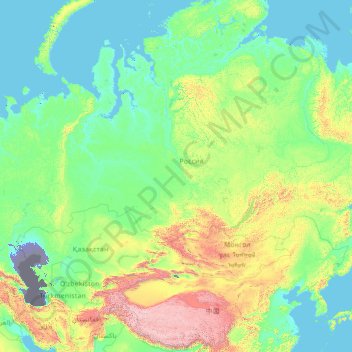
Asia topographic map
Interactive map
Click on the map to display elevation.
About this map
Name: Asia topographic map, elevation, terrain.
Location: Asia (26.20870 64.23437 76.20870 114.23437)
Average elevation: 1,847 ft
Minimum elevation: -98 ft
Maximum elevation: 24,108 ft
Other topographic maps
Click on a map to view its topography, its elevation and its terrain.
Austin
United States > Texas > Travis County
Austin features a diverse and varied topography shaped by its position along the Balcones Fault. The city’s elevation ranges from about 425 feet to approximately 1,000 feet above sea level, creating a landscape characterized by rolling hills and elevated areas particularly in the western regions. To the…
Average elevation: 709 ft
Kerrville
United States > Texas > Kerr County
Kerrville is characterized by a diverse and rugged topography. Nestled along the Guadalupe River, it sits at an elevation averaging 1,600 feet above sea level, with varying terrain that includes gentle hills, steep slopes, and flat river valleys. This area features numerous limestone hills, characteristic of…
Average elevation: 1,788 ft
United States
The topography of the United States is characterized by diverse and dynamic landscapes that vary widely across the country. In the east, rolling hills and low mountains transition into the Appalachian Mountains, featuring peaks that generally reach around 6,000 feet (1,829 meters). Moving westward, the terrain…
Average elevation: 1,014 ft
Texas
Texas showcases a diverse and expansive topography that spans approximately 268,000 square miles (694,117 Km²), making it the second-largest state in the United States. The landscape ranges from the arid deserts of West Texas, characterized by broad valleys and mesas, to the rolling hills of the Texas Hill…
Average elevation: 1,699 ft
Georgetown
United States > Texas > Williamson County
Georgetown lies in the central part of Williamson County and features a diverse topography influenced by the Balcones Escarpment. The city itself sits at an average elevation of about 800 feet (244 meters), with its terrain ranging from flatter areas in the east to more hilly and karst-like features in the…
Average elevation: 810 ft
San Marcos
United States > Texas > Hays County
San Marcos is characterized by its diverse topography, which includes rolling hills, lush riverbanks, and scenic limestone outcroppings. The city is situated at an elevation of approximately 600 feet above sea level, providing a backdrop of gently undulating terrain that slopes towards the banks of the San…
Average elevation: 682 ft
Williamson County
The area is divided into two regions by the Balcones Escarpment, which runs through the center from north to south along a line from Jarrell to Georgetown to Round Rock. The county's western half is an extension of the Western Plains and considered to be within the eastern fringes of Texas Hill Country; it has…
Average elevation: 728 ft
Travis County
Travis County features a varied and dynamic topography characterized by rolling hills, lush valleys, and significant water features. The terrain rises gently from the flatlands in the east to the more rugged and elevated areas in the west, reaching elevations of up to about 1,400 feet above sea level. The…
Average elevation: 758 ft
San Antonio
United States > Texas > Bexar County
San Antonio features a diverse topography characterized by gently rolling hills and flat plains. The city's elevation averages around 650 feet above sea level, but nearby areas can reach heights of up to 1,300 feet in certain locations like Cross Mountain. The landscape is part of the southern edge of the…
Average elevation: 810 ft
Florida
Florida's topography is characterized by its predominantly flat landscape, with the highest elevation being Britton Hill at just 345 feet (105 meters) above sea level, making it the lowest high point of any U.S. state. The state is primarily divided into three physiographic regions: the Atlantic Coastal Plain,…
Average elevation: 20 ft
Nashville
United States > Tennessee > Davidson County
Nashville-Davidson, features a diverse topography characterized by its position in the Nashville Basin and the Highland Rim. The terrain is predominantly hilly, with elevations ranging from approximately 385 feet at the Cumberland River to around 1,163 feet in areas like Radnor Lake State Natural Area. This…
Average elevation: 604 ft
Seattle
United States > Washington > King County
Seattle features a diverse topography characterized by its unique geographical setting between Puget Sound and Lake Washington. The city is situated on an isthmus, which contributes to its dramatic landscape, featuring rolling hills and steep slopes that rise abruptly from the waterfront. The average elevation…
Average elevation: 131 ft
San Francisco
San Francisco is characterized by its striking and varied topography, making it one of the most distinctive cities in the United States. The landscape features a mix of rolling hills and steep inclines, with the highest elevation reaching approximately 922 feet at Twin Peaks. The average elevation across the…
Average elevation: 207 ft
Denver
United States > Colorado > Denver County > Denver
Denver, situated at an elevation of 5,280 feet (1,609 meters), is renowned as the "Mile High City." It is located in the South Platte River Valley, just east of the Rocky Mountains' foothills. The city's topography features a gently sloping landscape characterized by rolling hills and wide valleys,…
Average elevation: 5,525 ft
Michigan
Michigan's topography is characterized by a diverse landscape that transitions from flat plains to rugged hills. The state comprises two peninsulas, with the Upper Peninsula showcasing more pronounced elevation changes, including its highest point, Mount Arvon, which rises to 1,979 feet (603 meters). In…
Average elevation: 850 ft
Lago Vista
United States > Texas > Travis County
Lago Vista is situated on the northern shore of Lake Travis within the Texas Hill Country. The area's terrain is notably rugged, with steep limestone hills and canyons. Elevations range from about 774 feet near the lake to 1,220 feet near Rusty Allen Airport, making it one of the highest points in Travis…
Average elevation: 823 ft
San Diego
United States > California > San Diego County
San Diego is characterized by a diverse topography that features coastal plains, rolling hills, and rugged mountain ranges. The city is situated along the Pacific Ocean, where it boasts an extensive shoreline with sandy beaches and tidal zones. As you move inland, the landscape transitions from the flat…
Average elevation: 410 ft
Arizona
Arizona's topography is highly diverse, shaped by three distinct regions: the Colorado Plateau, the Basin and Range Province, and the Transition Zone. The northern Colorado Plateau is characterized by flat, high plains over 4,000 feet in elevation, including the Grand Canyon and its breathtaking cliffs. In…
Average elevation: 4,032 ft
Round Rock
United States > Texas > Williamson County
Round Rock sits at an approximate elevation of 735 feet above sea level and spans a diverse terrain shaped by the Balcones Escarpment. This geological fault line divides the city into two distinct landscapes: the eastern side lies on the relatively flat and fertile Blackland Prairie, characterized by deep,…
Average elevation: 794 ft
Colorado
Colorado's topography is characterized by a diverse range of elevations and landforms, making it one of the most geologically varied states in the U.S. The state is dominated by the Rocky Mountains, which run north to south and include the highest peak in the contiguous United States, Mount Elbert, towering at…
Average elevation: 6,759 ft
New York
New York City's topography is a fascinating blend of varied elevations and unique landscapes, reflecting its diverse geography across five boroughs. Situated at the confluence of the Hudson and East Rivers, the city primarily features low-lying terrain, with the average elevation hovering around sea level.…
Average elevation: 62 ft
Salt Lake City
United States > Utah > Salt Lake County
Salt Lake City's topography is characterized by a striking contrast between its flat valley floor and the surrounding rugged mountains. The city is situated in the Salt Lake Valley, with an average elevation of approximately 4,237 feet above sea level, making it one of the higher major cities in the United…
Average elevation: 5,223 ft
Portland
United States > Oregon > Multnomah County
Portland features a striking and varied topography characterized by its location at the confluence of the Willamette and Columbia Rivers. The city lies within the fertile Willamette Valley, flanked by the snow-capped Cascade Mountains to the east, including the prominent Mount Hood, and the less elevated…
Average elevation: 253 ft
Missouri
Missouri's topography is marked by a diverse array of landforms that contribute to its unique landscape. The state is characterized by four main physiographic regions: the Ozark Plateau, Dissected Till Plains, Mississippi Alluvial Plain, and the Osage Plains. The Ozark Plateau, located in the south, features…
Average elevation: 827 ft
North Carolina
North Carolina features a diverse topography that can be divided into three distinct regions: the Coastal Plain, the Piedmont, and the Appalachian Mountains. The Coastal Plain, which occupies the eastern part of the state, is characterized by flat and gently sloping land, with elevations typically less than…
Average elevation: 535 ft
Pennsylvania
Pennsylvania's topography is characterized by its rich diversity, ranging from the rugged Appalachian Mountains in the south to the flatlands of the northern plateau. The state's elevation varies significantly, with the highest point being Mount Davis at approximately 3,213 feet (979 meters) and the lowest at…
Average elevation: 1,115 ft
Dallas
United States > Texas > Dallas County
Dallas features a predominantly flat terrain characterized by elevations generally ranging from 450 to 550 feet (137 to 168 meters) above sea level. The landscape is shaped significantly by the western edge of the Austin Chalk Formation, a limestone escarpment known as the White Rock Escarpment, which rises…
Average elevation: 525 ft
Atlanta
United States > Georgia > Fulton County
Atlanta features a varied topography characterized by its rolling hills and elevated terrain. The city sits at an average elevation of approximately 1,050 feet (320 meters) above sea level, with elevations ranging from about 725 feet (221 meters) to 1,175 feet (358 meters) in the surrounding areas. This…
Average elevation: 932 ft
Saint Petersburg
United States > Florida > Pinellas County
Saint Petersburg features a predominantly flat topography characteristic of the Gulf Coast region. The city's elevation averages around 44 feet (approximately 13.4 meters) above sea level, with some areas dipping to about 15 feet (4.6 meters). This relatively low elevation contributes to the area's…
Average elevation: 13 ft
Kansas City
United States > Missouri > Jackson County
Kansas City features a diverse topography characterized by rolling hills and valleys, with elevations ranging from about 794 to 997 feet above sea level. The landscape is shaped by the confluence of the Missouri and Kansas rivers, resulting in a mix of elevated areas and flat river plains. The region's average…
Average elevation: 909 ft
Oklahoma
Oklahoma features a diverse and complex topography characterized by its mixture of plains, plateaus, and mountainous regions. The state is divided into distinct physiographic regions, including the flat Prairie Plains that dominate much of the northern and central areas, and the rugged Ozark Plateau in the…
Average elevation: 1,339 ft
New Mexico
New Mexico's topography is strikingly diverse, characterized by a mix of high mountain ranges, arid plains, and expansive desert regions. The state is primarily defined by the Rocky Mountains, which run north to south through its central region, featuring peaks that reach over 13,000 feet, such as Wheeler…
Average elevation: 5,535 ft
Virginia
Virginia's topography is characterized by a diverse landscape that transitions from the Atlantic Coastal Plain in the east to the mountainous regions in the west. The Coastal Plain features flat, low-lying areas that gradually rise to the Piedmont, known for its rolling hills and valleys. Further west, the…
Average elevation: 814 ft
Delaware
Delaware's topography is characterized by a distinctive blend of low-lying plains and gentle hills, reflective of its geographical positioning on the Atlantic Coastal Plain and the Appalachian Piedmont. The state predominantly features flat terrain, especially in its southern regions, where elevations rarely…
Average elevation: 52 ft
Conroe
United States > Texas > Montgomery County
Conroe features a predominantly flat terrain with an average elevation of approximately 220 feet (67 meters) above sea level. The area is characterized by gently rolling hills interspersed with numerous lakes and wetlands, including the prominent Lake Conroe, which spans about 21,000 acres. The lake, formed by…
Average elevation: 203 ft
Blowing Rock
United States > North Carolina > Watauga County
Blowing Rock is characterized by its rugged and varied topography, nestled within the southern reaches of the Blue Ridge Mountains. The town itself is situated on a prominent ridge, with elevations ranging from approximately 3,300 to 3,600 feet, creating dramatic landscapes that feature steep slopes, rocky…
Average elevation: 3,386 ft
Phoenix
United States > Arizona > Maricopa County
Phoenix is characterized by a unique topographical landscape nestled in the Salt River Valley. This valley, at an average elevation of about 1,086 feet, is framed by several prominent mountain ranges, creating a striking contrast between the flat plains and elevated terrains. Notable peaks such as Camelback…
Average elevation: 1,578 ft
Greenville
United States > South Carolina > Greenville County
Greenville features a varied topography characterized by rolling hills and the nearby Blue Ridge Mountains. The city sits at an elevation of approximately 984 feet (300 meters) above sea level, with its landscape shaped significantly by the Reedy River, which flows through the heart of downtown, creating…
Average elevation: 951 ft
Raleigh
United States > North Carolina > Wake County
Raleigh features a topography primarily defined by its position along the fall line, which is the geological boundary between the Piedmont and Coastal Plain regions. This area experiences a gradual elevation drop of approximately 150 to 350 feet over a distance of 1 to 3 miles as one moves eastward. The city's…
Average elevation: 338 ft
West Virginia
West Virginia is renowned for its mountainous terrain, primarily part of the Appalachian Mountain system. The state's topography is characterized by steep ridges, deep valleys, and rugged plateaus. The Allegheny Plateau dominates much of the western and central regions, with its dissected hills and valleys,…
Average elevation: 1,411 ft
Bend
United States > Oregon > Deschutes County
Bend is characterized by its distinctive topography, situated at an elevation of approximately 3,623 feet (1,105 meters) above sea level. The city lies within the high desert region of Central Oregon, bordered by the Cascade Mountains to the west, which provide a dramatic backdrop with peaks like the Three…
Average elevation: 3,678 ft
Asheville
United States > North Carolina > Buncombe County
Asheville, located in Buncombe County, North Carolina, is characterized by a diverse and picturesque topography primarily shaped by its position within the Blue Ridge Mountains. The city itself sits at an elevation of approximately 2,200 feet, surrounded by peaks that rise significantly higher, such as Mount…
Average elevation: 2,385 ft
Gainesville
United States > Florida > Alachua County
Gainesville is situated in a region characterized by gently rolling hills and a mix of flatlands, typical of north-central Florida's terrain. The elevation ranges from approximately 50 to 200 feet above sea level, providing a scenic landscape dotted with lush vegetation and various waterways, including the…
Average elevation: 138 ft
Wisconsin
Wisconsin's topography is characterized by a diverse landscape shaped by glacial activity, resulting in a mixture of rolling hills, flat plains, and numerous lakes. The state’s highest point is Timms Hill, reaching an elevation of 1,952 feet (595 meters), while its lowest point is the shore of Lake Michigan…
Average elevation: 988 ft
Oregon
Oregon's topography is strikingly diverse, characterized by an array of geographical features that shape its unique landscape. The state is framed by two significant mountain ranges: the Pacific Coast Range to the west and the Cascade Mountains running north to south through the center. This mountainous…
Average elevation: 3,077 ft
Washington
Washington State's topography is characterized by dramatic contrasts, shaped primarily by the formidable Cascade Mountain Range that divides the state into distinct western and eastern regions. The western part is marked by rugged mountains, lush forests, and a plethora of lakes, resulting from glacial…
Average elevation: 2,612 ft
Wilmington
United States > North Carolina > New Hanover County
Wilmington sits near the southeastern coast and has a low-lying, relatively flat topography with an average elevation around 36 feet above sea level. The terrain is characterized by coastal plains with minimal elevation changes, making the landscape generally flat as it gently slopes toward the Atlantic Ocean.…
Average elevation: 23 ft
Ukraine
Ukraine's topography is characterized by a striking contrast of features across its vast landscape. The country predominantly consists of fertile plains and steppes, especially in the central and southern regions, where elevations typically range from sea level to around 600 meters (1,969 feet) above sea…
Average elevation: 600 ft
Pittsburgh
United States > Pennsylvania > Allegheny County
Pittsburgh, located in Allegheny County, Pennsylvania, is characterized by its distinct and varied topography, shaped by the confluence of the Allegheny, Monongahela, and Ohio rivers. The city itself is situated at an average elevation of approximately 764 feet (233 meters) above sea level, with the terrain…
Average elevation: 994 ft
Blue Ridge
United States > Georgia > Fannin County
Blue Ridge, situated in Fannin County, Georgia, lies within the rugged terrain of the southern Appalachian Mountains. The town itself is at an elevation of approximately 1,762 feet (537 meters) above sea level. The surrounding landscape is characterized by a series of ridges and valleys, with elevations…
Average elevation: 1,755 ft
Scottsdale
United States > Arizona > Maricopa County
Scottsdale features a diverse topography shaped by its location within the Sonoran Desert and the foothills of the McDowell Mountains. The city sits at an average elevation of about 1,827 feet (558 meters), with a range that spans from approximately 1,052 feet (321 meters) at its lowest points to 4,819 feet…
Average elevation: 1,814 ft
Tulsa
United States > Oklahoma > Tulsa County
Tulsa, located in northeastern Oklahoma, is characterized by a diverse and rolling topography that marks its transition from the Great Plains to the Ozark foothills. The city's elevation averages around 700 feet (approximately 210 meters) above sea level, with some areas reaching heights of up to 1,050 feet…
Average elevation: 725 ft
Reno
United States > Nevada > Washoe County
Reno is characterized by its diverse topography, which is shaped by its elevation and the surrounding mountain ranges. Situated at an average elevation of approximately 4,500 feet (about 1,370 meters), the city is nestled in a high desert region that features a mix of flat valleys and gently rolling hills.…
Average elevation: 5,413 ft
Grand Rapids
United States > Michigan > Kent County
Grand Rapids is situated in a region characterized by relatively flat terrain that gently undulates, influenced by the glacial activity that shaped much of the Midwest. The city itself sits at an elevation of approximately 640 feet (195 meters) above sea level, with the surrounding landscape showcasing low…
Average elevation: 709 ft
Orlando
United States > Florida > Orange County
Orlando features a predominantly flat terrain characterized by gentle hills and low-lying areas, with elevations typically ranging from 50 to 100 feet above sea level. Despite its overall flatness, the topography includes marshes and wetlands due to the presence of numerous lakes and rivers, contributing to a…
Average elevation: 98 ft
South Dakota
South Dakota's topography is characterized by a striking contrast between its eastern and western regions. The eastern part features gently rolling hills and fertile plains, which are part of the Great Plains, known for their rich agricultural lands, particularly ideal for crops like wheat and corn. As one…
Average elevation: 2,352 ft
Ohio
Ohio's topography is characterized by a diverse landscape that ranges from the flat plains in the north to the rolling hills and rugged terrain in the southeast. The state can be divided into several distinct regions, including the Great Lakes Plains to the north, the Central Plains in the west, and the…
Average elevation: 912 ft
California
California's topography is characterized by a remarkable diversity that includes expansive mountain ranges, deep valleys, and vast deserts. The Sierra Nevada mountains dominate the eastern part of the state, with peaks such as Mount Whitney rising to 14,494 feet (4,418 meters), making it the tallest point in…
Average elevation: 3,048 ft
Omaha
United States > Nebraska > Douglas County
Omaha features a varied topography characterized by rolling hills and valleys that rise gently from the Missouri River, which forms the city's eastern boundary. The landscape is primarily composed of prairie and hardwood forests, offering a mix of open spaces and wooded areas. Elevations within the city range…
Average elevation: 1,109 ft
Fort Myers
United States > Florida > Lee County
Fort Myers, located in Lee County, Florida, features a predominantly flat topography characterized by low elevations, averaging around 10 to 16 feet (approximately 3 to 5 meters) above sea level. The area is primarily composed of coastal plains, which contribute to its lush, subtropical vegetation and…
Average elevation: 16 ft
Bakersfield
United States > California > Kern County
Most of Bakersfield's major streets are six-lane divided roads with bike lanes, with almost every street in the city having proper lane signage for bicycle traffic. Bikes are a popular method of transportation in Bakersfield, due to the city's relatively flat topography and grid-like street system. Newer…
Average elevation: 515 ft
Fredericksburg
United States > Texas > Gillespie County
Enchanted Rock is a geographical landmark 27 km (17 mi) north of Fredericksburg in Llano County. The rock is a huge, pink granite exfoliation dome that rises 425 ft (130 m) above the surrounding land, has a summit elevation of 1,825 ft (556 m) above sea level, and covers 640 acres (260 ha). Enchanted Rock…
Average elevation: 1,726 ft
Punta Gorda
United States > Florida > Charlotte County
Punta Gorda features a predominantly flat topography characterized by its low elevation, averaging around 7 to 10 feet above sea level. The terrain is primarily made up of coastal plains and wetlands, interspersed with small hills such as those found in South Punta Gorda Heights, which can reach elevations of…
Average elevation: 10 ft
Tennessee
Tennessee features a diverse and varied topography characterized by its distinct regions, which include the Appalachian Mountains, the Central Basin, and the Gulf Coastal Plain. The state’s highest point is Clingmans Dome, rising to about 6,643 feet (2,025 meters) above sea level, while the lowest point is…
Average elevation: 764 ft
Cleveland
United States > Tennessee > Bradley County
The area's terrain is made up of parallel ridges, including Candies Creek Ridge (also called Clingan Ridge), Mouse Creek/Lead Mine Ridge, and Blue Springs Ridge, which are extensions of the Appalachian Mountains (specifically part of the Ridge-and-Valley Appalachians) that run approximately north-northeast…
Average elevation: 866 ft
Mexico
Mexico's topography is characterized by a remarkable diversity, featuring rugged mountains, expansive plateaus, and lush coastal plains. The Sierra Madre Occidental and Sierra Madre Oriental mountain ranges run parallel to the country's western and eastern coasts, respectively, creating a central highland…
Average elevation: 1,352 ft
Vero Beach
United States > Florida > Indian River County
Vero Beach, located along Florida's Atlantic coast, features relatively flat and low-lying terrain. The area has an average elevation of around 25 feet above sea level, with the highest point reaching about 40 feet. This coastal region is predominantly characterized by sandy beaches and wetlands, interspersed…
Average elevation: 20 ft
Eugene
United States > Oregon > Lane County
Eugene is characterized by a varied topography that contributes to its picturesque landscapes. The city sits at an average elevation of about 426 feet (130 meters) and is nestled within the Willamette Valley, surrounded by the foothills of the Cascade Mountains to the east, which rise significantly in…
Average elevation: 535 ft
Tallahassee
United States > Florida > Leon County
Tallahassee features a distinctive topography that is characterized by hilly terrain, which is somewhat atypical for the generally flat landscape of the state. The city is located at the southern end of the Red Hills Region and just above the Cody Scarp, with elevations ranging from about 7 feet near its low…
Average elevation: 118 ft
Las Vegas
United States > Nevada > Clark County
Las Vegas is characterized by its distinctive topography, which features a mix of arid desert landscapes and mountainous terrain. The city itself sits at an elevation of approximately 2,030 feet (620 meters) above sea level, while the surrounding peaks reach heights exceeding 10,000 feet (3,000 meters),…
Average elevation: 2,480 ft
New Jersey
New Jersey's topography is characterized by a diverse landscape that ranges from coastal plains to rolling hills and rugged mountains. The state features a predominantly low elevation along its eastern coastline, where major cities like Newark and Jersey City are located. This coastal lowland, which includes…
Average elevation: 236 ft
Indiana
Indiana's topography is characterized by gently rolling hills, primarily in the central and southern regions, and flat plains in the north. The state's average elevation is around 650 feet, with the highest point being Hoosier Hill at approximately 1,257 feet, located in Wayne County. The lowest elevation,…
Average elevation: 741 ft
Pinellas County
Pinellas County features a predominantly flat terrain, characterized by low-lying coastal plains that rise gently from the shores of the Gulf of Mexico. The highest points in the county reach around 60 feet above sea level, primarily found in the northern sections. The area is interspersed with numerous water…
Average elevation: 13 ft
Minneapolis
United States > Minnesota > Hennepin County
Minneapolis is characterized by a diverse and dynamic topography. The city sits at an average elevation of approximately 830 feet (253 meters) above sea level, but this varies significantly across its landscape. The terrain is predominantly flat, interspersed with rolling hills, and is marked by the presence…
Average elevation: 886 ft
Houston
United States > Texas > Harris County
Houston is characterized by its predominantly flat topography, sitting at an average elevation of approximately 59 feet (18 meters) above sea level. The city is situated on the Gulf Coastal Plain, which is dissected by a network of bayous that contribute to the region's drainage. This terrain was once covered…
Average elevation: 82 ft
Tacoma
United States > Washington > Pierce County
Tacoma is at 47°14′29″N 122°27′34″W / 47.24139°N 122.45944°W / 47.24139; -122.45944 (47.241371, −122.459389). Its official elevation is 381 feet (116 m), varying between sea level and about 500 feet (150 m).
Average elevation: 220 ft
Myrtle Beach
United States > South Carolina > Horry County
Myrtle Beach features a predominantly flat topography characterized by its coastal plain setting. The area is situated just a few feet above sea level, with an average elevation of approximately 20 feet (6 meters), making it ideal for expansive sandy beaches and shallow tidal estuaries. The region is part of a…
Average elevation: 20 ft
Fort Collins
United States > Colorado > Larimer County
Fort Collins is situated at an elevation of approximately 5,003 feet (1,524 meters) above sea level, nestled at the base of the Rocky Mountains in northern Colorado. The city features a varied topography characterized by gently rolling plains that gradually rise to foothills, creating a picturesque backdrop.…
Average elevation: 5,079 ft