
Caddo County topographic map
Interactive map
Click on the map to display elevation.
About this map
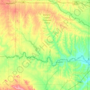
Name: Caddo County topographic map, elevation, terrain.
Location: Caddo County, Oklahoma, United States (34.85501 -98.62395 35.55157 -98.09124)
Average elevation: 1,430 ft
Minimum elevation: 1,089 ft
Maximum elevation: 2,178 ft
Oklahoma trails, hiking, mountain biking, running and outdoor activities
Other topographic maps
Click on a map to view its topography, its elevation and its terrain.
Keystone Lake
United States > Oklahoma > Osage County > Westport
The spillway is a gated ogee weir, 720 feet (220 m) wide with eighteen tainter gates, each 40 by 35 feet (12 by 11 m). Spillway capacity at the maximum pool level (elevation 766.0 feet (233.5 m)) is 939,000 cubic feet per second (26,600 m3/s). Capacity at the top of the flood control pool level (elevation…
Average elevation: 791 ft
Feyodi Creek State Park
United States > Oklahoma > Pawnee County > Cleveland
Average elevation: 774 ft
Scissortail Park
United States > Oklahoma > Oklahoma County > Oklahoma City
Average elevation: 1,198 ft