
Make a donation
Gear up for your next adventure:
As an Amazon Associate, this site earns from qualifying purchases at no extra cost to you.
Namibia topographic map
Click on the map to display elevation.
Make a donation
Gear up for your next adventure:
As an Amazon Associate, this site earns from qualifying purchases at no extra cost to you.
Namibia
The Central Plateau runs from north to south, bordered by the Skeleton Coast to the northwest, the Namib Desert and its coastal plains to the southwest, the Orange River to the south, and the Kalahari Desert to the east. The Central Plateau is home to the highest point in Namibia at Königstein elevation 2,606 metres (8,550 ft).
Make a donation
Gear up for your next adventure:
As an Amazon Associate, this site earns from qualifying purchases at no extra cost to you.
About this map
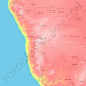
Name: Namibia topographic map, elevation, terrain.
Location: Namibia (-28.96945 11.52804 -16.96351 25.26173)
Average elevation: 2,569 ft
Minimum elevation: 0 ft
Maximum elevation: 7,638 ft
Make a donation
Gear up for your next adventure:
As an Amazon Associate, this site earns from qualifying purchases at no extra cost to you.
Other topographic maps
Click on a map to view its topography, its elevation and its terrain.
San Francisco Bay Area
United States > California > San Francisco
The San Francisco Bay Area is characterized by a diverse and dynamic topography shaped by geological processes over millions of years. This region features a combination of coastal plains, steep hills, and rugged mountains, all influenced by the tectonic activity associated with the nearby San Andreas Fault…
Average elevation: 371 ft
North America
North America's topography is characterized by its diverse and dramatic landscapes, stretching from the towering Rocky Mountains in the west to the expansive Great Plains in the central region, and the rugged Appalachian Mountains in the east. The Rocky Mountains, which include peaks exceeding 20,000 feet…
Average elevation: 965 ft
City of London
United Kingdom > England > City of London > City of London
The elevation of the City ranges from sea level at the Thames to 21.6 metres (71 ft) at the junction of High Holborn and Chancery Lane. Two small but notable hills are within the historic core, Ludgate Hill to the west and Cornhill to the east. Between them ran the Walbrook, one of the many "lost" rivers or…
Average elevation: 138 ft
Washington, D.C.
United States of America > Washington, D.C. > Washington, D.C.
The highest natural elevation in the District is 409 feet (125 m) above sea level at Fort Reno Park in upper northwest Washington. The lowest point is sea level at the Potomac River. The geographic center of Washington is near the intersection of 4th and L Streets NW.
Average elevation: 207 ft
Make a donation
Gear up for your next adventure:
As an Amazon Associate, this site earns from qualifying purchases at no extra cost to you.
Baltimore
Baltimore exhibits a diverse topography that plays a significant role in its character and development. Situated along the Patapsco River, which flows into the Chesapeake Bay, the city is positioned on the fall line that separates the Piedmont Plateau to the west from the Atlantic Coastal Plain to the east.…
Average elevation: 213 ft
Flagstaff
United States > Arizona > Coconino County
Flagstaff, located in Coconino County, Arizona, is characterized by its diverse topography, primarily shaped by its high elevation and volcanic activity. Sitting at around 7,000 feet (approximately 2,130 meters), the city is surrounded by the expansive Coconino National Forest, which features a blend of…
Average elevation: 7,139 ft
Fairbanks
United States > Alaska > Fairbanks North Star
Fairbanks is situated within the central Tanana Valley, characterized by a diverse and dynamic topography. The city straddles the Chena River, which flows southwest into the larger Tanana River, defining Fairbanks' southern border. To the north, a gradual incline leads into a chain of hills that ascend toward…
Average elevation: 479 ft
Make a donation
Gear up for your next adventure:
As an Amazon Associate, this site earns from qualifying purchases at no extra cost to you.
Atlanta
United States > Georgia > Fulton County
Atlanta occupies a high, rolling part of the Georgia Piedmont, a physiographic region described as a landscape of low hills and narrow valleys between the Blue Ridge Mountains and the Upper Coastal Plain. Around downtown and Fulton County, the terrain is gently dissected rather than flat, with broad urban…
Average elevation: 935 ft
East Texas
United States > Pennsylvania > Lehigh County > Lower Macungie Township
Average elevation: 413 ft
Make a donation
Gear up for your next adventure:
As an Amazon Associate, this site earns from qualifying purchases at no extra cost to you.
Gulf of Mexico
Average elevation: 66 ft
Boise
United States > Idaho > Ada County
Boise (locally /ˈbɔɪsi/ BOY-see) is the capital and most populous city of the U.S. state of Idaho and is the county seat of Ada County. As of the 2020 census, there were 235,684 people residing in the city. On the Boise River in southwestern Idaho, it is 41 miles (66 km) east of the Oregon border and 110…
Average elevation: 3,412 ft
Europe
Europe's topography is characterized by a striking contrast between its rugged southern mountains and the expansive plains of the north. The continent is often described as a "peninsula of peninsulas," featuring major peninsulas like the Iberian, Italian, and Balkan, each with unique geological features. In…
Average elevation: 732 ft
Make a donation
Gear up for your next adventure:
As an Amazon Associate, this site earns from qualifying purchases at no extra cost to you.
Appalachian Mountains
United States > North Carolina > Yancey County
The Appalachian Mountains (French: Appalaches), often called the Appalachians, are a system of mountains in eastern to northeastern North America. The Appalachians first formed roughly 480 million years ago during the Ordovician Period. They once reached elevations similar to those of the Alps and the Rocky…
Average elevation: 4,800 ft
Austria
According to the Köppen Climate Classification Austria has the following climate types: Oceanic (Cfb), Cool/Warm-summer humid continental (Dfb), Subarctic/Subalpine (Dfc), Tundra/Alpine (ET), and Ice-Cap (EF). It is important to note though that Austria may experience very cold, severe winters, but most of…
Average elevation: 1,096 ft
Make a donation
Gear up for your next adventure:
As an Amazon Associate, this site earns from qualifying purchases at no extra cost to you.
Himalayas
Nepal > Koshi Province > Solukhumbu
The Himalayas present a dramatic and varied topography characterized by towering peaks, deep valleys, and extensive glaciers. This majestic mountain range features some of the highest elevations on Earth, including Mount Everest, which rises to 29,035 feet. The terrain is marked by steep, jagged ridges and…
Average elevation: 24,787 ft
Elizabethton
United States > Tennessee > Carter County > Elizabethton > Elizabethton
The elevation at Elizabethton Municipal Airport is 1,593 feet (486 m) ASL (the highest point of elevation in Carter County is at Roan Mountain with an elevation of 6,285 feet (1,916 m) ASL), and the airport is located on the eastern side of the city along State Highway 91 Stoney Creek Exit. Elizabethton is…
Average elevation: 1,729 ft
San Fernando Valley
United States > California > Los Angeles County > Los Angeles
Average elevation: 1,627 ft
Make a donation
Gear up for your next adventure:
As an Amazon Associate, this site earns from qualifying purchases at no extra cost to you.
Tallahassee
United States > Florida > Leon County > Tallahassee
Tallahassee's terrain is hilly by Florida standards, being at the southern end of the Red Hills Region, just above the Cody Scarp. The elevation varies from near sea level to just over 200 feet (61 m), with the state capitol on one of the highest hills in the city. The city includes two large lake basins, Lake…
Average elevation: 105 ft
Port Charlotte
United States > Florida > Charlotte County
Port Charlotte is characterized by a predominantly flat and low-lying terrain, typical of Florida’s coastal landscape. The area features a network of waterways, including the Peace River and Charlotte Harbor, which provide ample opportunities for recreational activities like boating and fishing. Elevations…
Average elevation: 13 ft
Make a donation
Gear up for your next adventure:
As an Amazon Associate, this site earns from qualifying purchases at no extra cost to you.
Placerville
United States > California > Placerville
The region east of Placerville, popularly known as Apple Hill and Pleasant Valley, is becoming a center for wine production. The wine region is officially designated as the El Dorado AVA. The largest wineries in the area are Boeger, Lava Cap and Madrona, but most of the 30 plus wineries surrounding Placerville…
Average elevation: 1,926 ft
Blue Ridge Mountains
United States > Virginia > Botetourt County
Although the term "Blue Ridge" is sometimes applied exclusively to the eastern edge or front range of the Appalachian Mountains, the geological definition of the Blue Ridge province extends westward to the Ridge and Valley area, encompassing the Great Smoky Mountains, the Great Balsams, the Roans, the Blacks,…
Average elevation: 1,509 ft
Make a donation
Gear up for your next adventure:
As an Amazon Associate, this site earns from qualifying purchases at no extra cost to you.
Algiers Point
United States > Louisiana > Orleans Parish > New Orleans > Algiers
Average elevation: 10 ft
Wilmington Island
United States > Georgia > Chatham County > Wilmington Island
Average elevation: 10 ft
Make a donation
Gear up for your next adventure:
As an Amazon Associate, this site earns from qualifying purchases at no extra cost to you.
Istanbul
Istanbul, located in northwestern Turkey, is a city that is uniquely situated across two continents, Europe and Asia, divided by the Bosphorus Strait. The city’s topography is characterized by a complex blend of hills, valleys, and coastal plains, which create a varied and scenic landscape. The European side…
Average elevation: 187 ft
Evergreen
United States > Colorado > Jefferson County
Evergreen sits at an elevation of 7,220 feet (2,200 m) in the Rocky Mountains, 19 miles west of Denver, Colorado. Its addresses are oriented according to the Street_system_of_Denver.
Average elevation: 7,575 ft
Make a donation
Gear up for your next adventure:
As an Amazon Associate, this site earns from qualifying purchases at no extra cost to you.
Pinetop-Lakeside
United States > Arizona > Navajo County
Pinetop-Lakeside is nestled in the stunning White Mountains of northeastern Arizona, characterized by a varied topography that significantly influences its natural beauty and recreational opportunities. The terrain features elevations averaging around 6,795 feet, with rugged mountain landscapes interspersed…
Average elevation: 6,847 ft
Nokomis
United States > Florida > Sarasota County
Nokomis features a predominantly flat and low-lying terrain characteristic of the coastal region. The elevation in Nokomis rarely exceeds 15 feet above sea level, contributing to its vulnerability to tidal influences and storm surges. The area is interspersed with wetlands and mangroves, particularly near the…
Average elevation: 16 ft
Bozeman
United States > Montana > Gallatin County
Bozeman is located at an elevation of 4,820 feet (1,470 m). The Bridger Mountains are to the north-northeast, the Tobacco Root Mountains to the west-southwest, the Big Belt Mountains and Horseshoe Hills to the northwest, the Hyalite Peaks of the northern Gallatin Range to the south and the Spanish Peaks of the…
Average elevation: 5,509 ft
Make a donation
Gear up for your next adventure:
As an Amazon Associate, this site earns from qualifying purchases at no extra cost to you.
Mount Everest
Nepal > Eastern Development Region > Khumjung
Mount Everest (Chinese: 珠穆朗玛 Zhūmùlǎngmǎ; Nepali: सगरमाथा Sagarmāthā; Tibetan: Chomolungma ཇོ་མོ་གླང་མ) is Earth's highest mountain above sea level, located in the Mahalangur Himal sub-range of the Himalayas. The China–Nepal border runs across its summit…
Average elevation: 25,725 ft
Make a donation
Gear up for your next adventure:
As an Amazon Associate, this site earns from qualifying purchases at no extra cost to you.
Johannesburg
South Africa > Gauteng > City of Johannesburg Metropolitan Municipality
Johannesburg is located in the eastern plateau area of South Africa known as the Highveld, at an elevation of 1,753 metres (5,751 ft). The former Central Business District is located on the southern side of the prominent ridge called the Witwatersrand (English: White Water's Ridge) and the terrain falls to the…
Average elevation: 5,299 ft
Eighty Four
United States > Pennsylvania > Washington County > North Strabane Township
Average elevation: 1,132 ft
Anna Maria island
United States > Florida > Manatee County
Anna Maria Island features a flat, sandy topography typical of a barrier island on the Gulf Coast. With an average elevation of around 15 feet above sea level, the terrain includes broad beaches, low dunes, and narrow stretches of sandy soil, making it highly vulnerable to storm surges and tidal flooding. The…
Average elevation: 7 ft
Make a donation
Gear up for your next adventure:
As an Amazon Associate, this site earns from qualifying purchases at no extra cost to you.
Mount Vernon
United States > Kentucky > Rockcastle County > Mount Vernon > Mount Vernon
Average elevation: 1,194 ft
Make a donation
Gear up for your next adventure:
As an Amazon Associate, this site earns from qualifying purchases at no extra cost to you.
El Dorado Hills
United States > California > El Dorado County > Cameron Park
El Dorado Hills (EDH), as defined by the 2010 census-designated place (CDP), is at the western border of El Dorado County, between the City of Folsom and the unincorporated community of Cameron Park. The northern limits of the CDP are Folsom Lake and the South Fork of the American River, where river rafters…
Average elevation: 833 ft
Cuyahoga River
United States > Ohio > Cuyahoga County > Cleveland
The upper Cuyahoga River, starting at 1,093 feet (333 m) over 84 miles (135 km) from its mouth, drops in elevation fairly steeply, creating falls and rapids in some places; the lower Cuyahoga River only drops several feet along the last several miles of the lower river to 571 feet (174 m) at the mouth on Lake…
Average elevation: 643 ft
Make a donation
Gear up for your next adventure:
As an Amazon Associate, this site earns from qualifying purchases at no extra cost to you.
Scottish Highlands
United Kingdom > Scotland > Highland
The Scottish Highlands are renowned for their rugged, mountainous terrain that dominates much of the region. Stretching across the northern and central parts of Scotland, the landscape is shaped by ancient geological forces, including the Caledonian Orogeny, which caused significant tectonic collisions…
Average elevation: 2,976 ft
Lake Pueblo State Park
United States > Colorado > Pueblo County
Lake Pueblo (also known as Pueblo Reservoir) has a maximum depth of 135 feet (41 m) and is impounded by Pueblo Dam. Its surface elevation is 4,826 feet (1,471 meters).
Average elevation: 4,997 ft
Make a donation
Gear up for your next adventure:
As an Amazon Associate, this site earns from qualifying purchases at no extra cost to you.
South America
South America's topography is marked by remarkable diversity and dramatic contrasts. The continent is dominated by the Andes mountain range, which runs along its western edge, stretching over 4,300 miles from Venezuela to Chile. These mountains are home to some of the highest peaks in the Western Hemisphere,…
Average elevation: 928 ft
Henry Horton State Park
United States > Tennessee > Marshall County > Chapel Hill
Average elevation: 679 ft
Mexico City
Mexico > Mexico City > Mexico City
Mexico City is located in the Valley of Mexico, sometimes called the Basin of Mexico. This valley is located in the Trans-Mexican Volcanic Belt in the high plateaus of south-central Mexico. It has a minimum altitude of 2,200 meters (7,200 feet) above sea level and is surrounded by mountains and volcanoes that…
Average elevation: 7,615 ft
Make a donation
Gear up for your next adventure:
As an Amazon Associate, this site earns from qualifying purchases at no extra cost to you.
Stone Mountain
United States > Georgia > DeKalb County
The park is owned by the state of Georgia and is currently managed by Herschend Family Entertainment. At its summit, the elevation is 1,686 feet (514 m) above sea level and 825 feet (251 m) above the surrounding area. Stone Mountain is well known for not only its geology, but also the enormous rock relief on…
Average elevation: 981 ft
Homer
United States > Alaska > Kenai Peninsula
Many of the birds seen during the festival can be identified with the help of published guides that categorize distinguishable features such as, topography, silhouette, size, and color.
Average elevation: 341 ft
Augusta
United States > Georgia > Augusta
As with the rest of the state, Augusta has a humid subtropical climate (Köppen Cfa), with short, mild winters, very hot, humid summers, and a wide diurnal temperature variation throughout much of the year, despite its low elevation and moisture. The monthly daily average temperature ranges from 45.4 °F (7.4…
Average elevation: 295 ft
Make a donation
Gear up for your next adventure:
As an Amazon Associate, this site earns from qualifying purchases at no extra cost to you.
Badwater Basin
United States > California > Inyo County
The pool is not the lowest point of the basin: the lowest point (which is only slightly lower) is several miles to the west and varies in position, depending on rainfall and evaporation patterns. The salt flats are hazardous to traverse (in many cases being only a thin white crust over mud), and so the sign…
Average elevation: 499 ft
Make a donation
Gear up for your next adventure:
As an Amazon Associate, this site earns from qualifying purchases at no extra cost to you.
Monhegan Island
United States > Maine > Lincoln County > Monhegan Island Plantation > Monhegan
Average elevation: 16 ft
Make a donation
Gear up for your next adventure:
As an Amazon Associate, this site earns from qualifying purchases at no extra cost to you.
Three Sisters
United States > Oregon > Deschutes County
The Three Sisters are closely spaced volcanic peaks in the U.S. state of Oregon. They are part of the Cascade Volcanic Arc, a segment of the Cascade Range in western North America extending from southern British Columbia through Washington and Oregon to Northern California. Each more than 10,000 feet (3,000 m)…
Average elevation: 8,287 ft
Make a donation
Gear up for your next adventure:
As an Amazon Associate, this site earns from qualifying purchases at no extra cost to you.
Make a donation
Gear up for your next adventure:
As an Amazon Associate, this site earns from qualifying purchases at no extra cost to you.
San Gorgonio Pass
United States > California > Riverside County
The San Gorgonio Pass, or Banning Pass, is a 2,600 ft (790 m) elevation gap on the rim of the Great Basin between the San Bernardino Mountains to the north and the San Jacinto Mountains to the south. The pass was formed by the San Andreas Fault, a major transform fault between the Pacific plate and the North…
Average elevation: 1,614 ft
Make a donation
Gear up for your next adventure:
As an Amazon Associate, this site earns from qualifying purchases at no extra cost to you.
Columbus
United States > Ohio > Franklin County > Columbus
The confluence of the Scioto and Olentangy rivers is just north-west of Downtown Columbus. Several smaller tributaries course through the Columbus metropolitan area, including Alum Creek, Big Walnut Creek, and Darby Creek. Columbus is considered to have relatively flat topography thanks to a large glacier that…
Average elevation: 837 ft
Make a donation
Gear up for your next adventure:
As an Amazon Associate, this site earns from qualifying purchases at no extra cost to you.
Make a donation
Gear up for your next adventure:
As an Amazon Associate, this site earns from qualifying purchases at no extra cost to you.