
Akrotiri British Sovereign Base Area topographic map
Interactive map
Click on the map to display elevation.
About this map
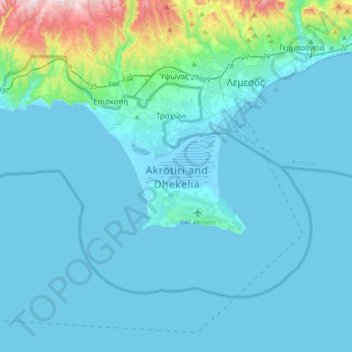
Name: Akrotiri British Sovereign Base Area topographic map, elevation, terrain.
Location: Akrotiri British Sovereign Base Area (34.51277 32.75451 34.70607 33.09695)
Average elevation: 174 ft
Minimum elevation: -20 ft
Maximum elevation: 1,818 ft
Other topographic maps
Click on a map to view its topography, its elevation and its terrain.
United States
The topography of the United States is characterized by diverse and dynamic landscapes that vary widely across the country. In the east, rolling hills and low mountains transition into the Appalachian Mountains, featuring peaks that generally reach around 6,684 feet. Moving westward, the terrain shifts to the…
Average elevation: 1,014 ft
Florida
Florida's topography is characterized by its predominantly flat landscape, with the highest elevation being Britton Hill at just 345 feet above sea level, making it the lowest high point of any U.S. state. The state is primarily divided into three physiographic regions: the Atlantic Coastal Plain, the East…
Average elevation: 20 ft
Arizona
Arizona's topography is highly diverse, shaped by three distinct regions: the Colorado Plateau, the Basin and Range Province, and the Transition Zone. The northern Colorado Plateau is characterized by flat, high plains over 4,000 feet in elevation, including the Grand Canyon and its breathtaking cliffs. In…
Average elevation: 4,032 ft
New York
New York City's topography is a fascinating blend of varied elevations and unique landscapes, reflecting its diverse geography across five boroughs. Situated at the confluence of the Hudson and East Rivers, the city primarily features low-lying terrain, with the average elevation hovering around sea level.…
Average elevation: 62 ft
Virginia
Virginia's topography is characterized by a diverse landscape that transitions from the Atlantic Coastal Plain in the east to the mountainous regions in the west. The Coastal Plain features flat, low-lying areas that gradually rise to the Piedmont, known for its rolling hills and valleys. Further west, the…
Average elevation: 814 ft
Texas
Texas showcases a diverse and expansive topography that spans approximately 268,000 square miles, making it the second-largest state in the United States. The landscape ranges from the arid deserts of West Texas, characterized by broad valleys and mesas, to the rolling hills of the Texas Hill Country, where…
Average elevation: 1,699 ft
Seattle
United States > Washington > King County
Seattle features a diverse topography characterized by its unique geographical setting between Puget Sound and Lake Washington. The city is situated on an isthmus, which contributes to its dramatic landscape, featuring rolling hills and steep slopes that rise abruptly from the waterfront. The average elevation…
Average elevation: 131 ft
San Francisco
San Francisco is characterized by its striking and varied topography, making it one of the most distinctive cities in the United States. The landscape features a mix of rolling hills and steep inclines, with the highest elevation reaching approximately 922 feet at Twin Peaks. The average elevation across the…
Average elevation: 207 ft
Ohio
Ohio's topography is characterized by a diverse landscape that ranges from the flat plains in the north to the rolling hills and rugged terrain in the southeast. The state can be divided into several distinct regions, including the Great Lakes Plains to the north, the Central Plains in the west, and the…
Average elevation: 912 ft
California
California's topography is characterized by a remarkable diversity that includes expansive mountain ranges, deep valleys, and vast deserts. The Sierra Nevada mountains dominate the eastern part of the state, with peaks such as Mount Whitney rising to 14,494 feet, making it the tallest point in the contiguous…
Average elevation: 3,048 ft
Austin
United States > Texas > Travis County
Austin features a diverse and varied topography shaped by its position along the Balcones Fault. The city’s elevation ranges from about 425 feet to approximately 1,000 feet above sea level, creating a landscape characterized by rolling hills and elevated areas particularly in the western regions. To the…
Average elevation: 709 ft
Dallas
United States > Texas > Dallas County
Dallas features a predominantly flat terrain characterized by elevations generally ranging from 450 to 550 feet (137 to 168 meters) above sea level. The landscape is shaped significantly by the western edge of the Austin Chalk Formation, a limestone escarpment known as the White Rock Escarpment, which rises…
Average elevation: 525 ft
Nashville-Davidson
United States > Tennessee > Davidson County
Nashville-Davidson, features a diverse topography characterized by its position in the Nashville Basin and the Highland Rim. The terrain is predominantly hilly, with elevations ranging from approximately 385 feet at the Cumberland River to around 1,163 feet in areas like Radnor Lake State Natural Area. This…
Average elevation: 604 ft
Wisconsin
Wisconsin's topography is characterized by a diverse landscape shaped by glacial activity, resulting in a mixture of rolling hills, flat plains, and numerous lakes. The state’s highest point is Timms Hill, reaching an elevation of 1,952 feet, while its lowest point is the shore of Lake Michigan at…
Average elevation: 988 ft
Puerto Rico
Puerto Rico features a diverse topography characterized by a mountainous interior, coastal plains, and stunning beaches. The island's central region is dominated by the Cordillera Central mountain range, which includes the highest peak, Cerro de Punta, rising to 4,390 feet (1,338 meters). These mountains…
Average elevation: 213 ft
Washington
Washington State's topography is characterized by dramatic contrasts, shaped primarily by the formidable Cascade Mountain Range that divides the state into distinct western and eastern regions. The western part is marked by rugged mountains, lush forests, and a plethora of lakes, resulting from glacial…
Average elevation: 2,612 ft
Philadelphia
United States > Pennsylvania > Philadelphia County
Philadelphia, located at the confluence of the Delaware and Schuylkill Rivers, features a diverse topography characterized by its gentle slopes and valleys. The city lies on the Atlantic Seaboard Fall Line, transitioning from the flat Coastal Plain to the more rugged Piedmont region. This unique geographical…
Average elevation: 144 ft
Phoenix
United States > Arizona > Maricopa County
Phoenix is characterized by a unique topographical landscape nestled in the Salt River Valley. This valley, at an average elevation of about 1,086 feet, is framed by several prominent mountain ranges, creating a striking contrast between the flat plains and elevated terrains. Notable peaks such as Camelback…
Average elevation: 1,578 ft
San Diego
United States > California > San Diego County
San Diego is characterized by a diverse topography that features coastal plains, rolling hills, and rugged mountain ranges. The city is situated along the Pacific Ocean, where it boasts an extensive shoreline with sandy beaches and tidal zones. As you move inland, the landscape transitions from the flat…
Average elevation: 410 ft
Oregon
Oregon's topography is strikingly diverse, characterized by an array of geographical features that shape its unique landscape. The state is framed by two significant mountain ranges: the Pacific Coast Range to the west and the Cascade Mountains running north to south through the center. This mountainous…
Average elevation: 3,077 ft
Denver
United States > Colorado > Denver County > Denver
Denver, situated at an elevation of 5,280 feet (1,609 meters), is renowned as the "Mile High City." It is located in the South Platte River Valley, just east of the Rocky Mountains' foothills. The city's topography features a gently sloping landscape characterized by rolling hills and wide valleys,…
Average elevation: 5,525 ft
Las Vegas
United States > Nevada > Clark County
Las Vegas is characterized by its distinctive topography, which features a mix of arid desert landscapes and mountainous terrain. The city itself sits at an elevation of approximately 2,030 feet (620 meters) above sea level, while the surrounding peaks reach heights exceeding 10,000 feet (3,000 meters),…
Average elevation: 2,480 ft
Chicago
United States > Illinois > Cook County
Chicago is characterized by its predominantly flat terrain, with an average elevation of about 579 feet (176 meters) above sea level. The city's landscape is primarily shaped by its proximity to Lake Michigan to the east, which influences local weather and provides a scenic waterfront. While the central areas…
Average elevation: 597 ft
Missouri
Missouri's topography is marked by a diverse array of landforms that contribute to its unique landscape. The state is characterized by four main physiographic regions: the Ozark Plateau, Dissected Till Plains, Mississippi Alluvial Plain, and the Osage Plains. The Ozark Plateau, located in the south, features…
Average elevation: 827 ft
Manhattan
United States > New York > New York County > New York
Manhattan, a densely populated urban island, has a diverse topography characterized by its generally flat terrain interspersed with elevated areas. The average elevation is about 50 feet (15 meters) above sea level, with its highest point reaching approximately 265 feet (81 meters) at Bennett Park in…
Average elevation: 52 ft
Kansas City
United States > Missouri > Jackson County
Kansas City features a diverse topography characterized by rolling hills and valleys, with elevations ranging from about 794 to 997 feet above sea level. The landscape is shaped by the confluence of the Missouri and Kansas rivers, resulting in a mix of elevated areas and flat river plains. The region's average…
Average elevation: 909 ft
Houston
United States > Texas > Harris County
Houston is characterized by its predominantly flat topography, sitting at an average elevation of approximately 59 feet (18 meters) above sea level. The city is situated on the Gulf Coastal Plain, which is dissected by a network of bayous that contribute to the region's drainage. This terrain was once covered…
Average elevation: 82 ft
Asheville
United States > North Carolina > Buncombe County
Asheville, located in Buncombe County, North Carolina, is characterized by a diverse and picturesque topography primarily shaped by its position within the Blue Ridge Mountains. The city itself sits at an elevation of approximately 2,200 feet, surrounded by peaks that rise significantly higher, such as Mount…
Average elevation: 2,385 ft
Michigan
Michigan's topography is characterized by a diverse landscape that transitions from flat plains to rugged hills. The state comprises two peninsulas, with the Upper Peninsula showcasing more pronounced elevation changes, including its highest point, Mount Arvon, which rises to 1,979 feet (603 meters). In…
Average elevation: 850 ft
Salt Lake City
United States > Utah > Salt Lake County
Salt Lake City's topography is characterized by a striking contrast between its flat valley floor and the surrounding rugged mountains. The city is situated in the Salt Lake Valley, with an average elevation of approximately 4,237 feet above sea level, making it one of the higher major cities in the United…
Average elevation: 5,223 ft
Tennessee
Tennessee features a diverse and varied topography characterized by its distinct regions, which include the Appalachian Mountains, the Central Basin, and the Gulf Coastal Plain. The state’s highest point is Clingmans Dome, rising to about 6,643 feet above sea level, while the lowest point is along the…
Average elevation: 764 ft
Colorado
Colorado's topography is characterized by a diverse range of elevations and landforms, making it one of the most geologically varied states in the U.S. The state is dominated by the Rocky Mountains, which run north to south and include the highest peak in the contiguous United States, Mount Elbert, towering at…
Average elevation: 6,759 ft
Pinellas County
Pinellas County features a predominantly flat terrain, characterized by low-lying coastal plains that rise gently from the shores of the Gulf of Mexico. The highest points in the county reach around 60 feet above sea level, primarily found in the northern sections. The area is interspersed with numerous water…
Average elevation: 13 ft
Tampa
United States > Florida > Hillsborough County
Tampa is characterized by a predominantly flat topography, with an average elevation around 16 to 49 feet above sea level. The terrain is marked by low-lying areas and gentle slopes, with the highest points in the vicinity reaching approximately 62 feet. This landscape is interspersed with numerous water…
Average elevation: 36 ft
Pittsburgh
United States > Pennsylvania > Allegheny County
Pittsburgh, located in Allegheny County, Pennsylvania, is characterized by its distinct and varied topography, shaped by the confluence of the Allegheny, Monongahela, and Ohio rivers. The city itself is situated at an average elevation of approximately 764 feet (233 meters) above sea level, with the terrain…
Average elevation: 994 ft
Detroit
United States > Michigan > Wayne County
The city slopes gently from the northwest to southeast on a till plain composed largely of glacial and lake clay. The most notable topographical feature in the city is the Detroit Moraine, a broad clay ridge on which the older portions of Detroit and Windsor are located, rising approximately 62 feet (19 m)…
Average elevation: 614 ft
San Antonio
United States > Texas > Bexar County
San Antonio features a diverse topography characterized by gently rolling hills and flat plains. The city's elevation averages around 650 feet above sea level, but nearby areas can reach heights of up to 1,300 feet in certain locations like Cross Mountain. The landscape is part of the southern edge of the…
Average elevation: 810 ft
Atlanta
United States > Georgia > Fulton County
Atlanta features a varied topography characterized by its rolling hills and elevated terrain. The city sits at an average elevation of approximately 1,050 feet (320 meters) above sea level, with elevations ranging from about 725 feet (221 meters) to 1,175 feet (358 meters) in the surrounding areas. This…
Average elevation: 932 ft
Columbus
United States > Ohio > Franklin County
Columbus is situated in the rolling hills of the Central Lowlands region, characterized by a predominantly flat to gently undulating terrain. The city itself is nestled on the banks of the Scioto River, which flows northward through the area, providing a picturesque waterfront and a variety of recreational…
Average elevation: 856 ft
Europe
Europe's topography is characterized by a diverse landscape that transitions dramatically from its mountainous southern regions to expansive northern plains. The continent is often described as a "peninsula of peninsulas," comprising various prominent peninsulas like the Iberian, Italian, and Balkan, which are…
Average elevation: 732 ft
Panama
Panama's topography is characterized by a striking diversity of landscapes that range from rugged mountains to expansive lowland plains. The interior of the country features the Central Cordillera, which includes some of the highest peaks such as Volcán Barú, reaching an elevation of about 11,400 feet (3,475…
Average elevation: 299 ft
Cincinnati
United States > Ohio > Hamilton County
Cincinnati features a distinctive topography characterized by its rolling hills and valleys. The city is situated on the north bank of the Ohio River, where the terrain rises sharply from the riverfront, reaching elevations of approximately 980 feet (299 meters) in some areas. The average elevation throughout…
Average elevation: 728 ft
Georgia
Georgia's topography is notably diverse, characterized by five main geographic regions that each contribute to its unique landscape. The southern part of the state features the Coastal Plain, a flat, low-lying area that gently slopes toward the Atlantic Ocean and is home to the expansive Okefenokee Swamp, one…
Average elevation: 446 ft
Portland
United States > Oregon > Multnomah County
Portland features a striking and varied topography characterized by its location at the confluence of the Willamette and Columbia Rivers. The city lies within the fertile Willamette Valley, flanked by the snow-capped Cascade Mountains to the east, including the prominent Mount Hood, and the less elevated…
Average elevation: 253 ft
Pennsylvania
Pennsylvania's topography is characterized by its rich diversity, ranging from the rugged Appalachian Mountains in the south to the flatlands of the northern plateau. The state's elevation varies significantly, with the highest point being Mount Davis at approximately 3,213 feet and the lowest at sea level…
Average elevation: 1,115 ft
Saint Petersburg
United States > Florida > Pinellas County
Saint Petersburg features a predominantly flat topography characteristic of the Gulf Coast region. The city's elevation averages around 44 feet (approximately 13.4 meters) above sea level, with some areas dipping to about 15 feet (4.6 meters). This relatively low elevation contributes to the area's…
Average elevation: 13 ft
Charlotte
United States > North Carolina > Mecklenburg County
Charlotte, located in the Piedmont region of North Carolina, features a gently rolling terrain characterized by elevations ranging from approximately 650 to 700 feet (198 to 213 meters). The city is bordered to the west by the Catawba River, which contributes to the area's mild climate and lush vegetation.…
Average elevation: 679 ft
Morris County
The county rises in elevation and relief from east to west, with only the more developed eastern suburbs in the Passaic River valley being relatively level. The highest point is at 1,395 feet (425 m) above sea level on a mountain south of Pine Swamp in western Jefferson Township. The second-highest point is on…
Average elevation: 597 ft
Duluth
United States > Minnesota > Saint Louis County
Duluth's topography is distinctive, defined by its hilly terrain and its proximity to Lake Superior. The city is perched on an incline rising sharply from the lake, with elevations ranging from lake level at about 600 feet to approximately 1,400 feet at the ridge tops. This steep gradient creates dramatic…
Average elevation: 938 ft
Tucson
United States > Arizona > Pima County
Tucson is situated on an alluvial plain in the Sonoran Desert, at an elevation of approximately 2,400 feet (730 meters) above sea level. The city is enveloped by five mountain ranges, which contribute significantly to its varied topography. To the north lie the Santa Catalina and Tortolita Mountains, while the…
Average elevation: 2,697 ft
Idaho
Idaho's topography is characterized by its remarkable diversity, featuring vast mountain ranges, deep river canyons, and extensive plains. The state is home to over 75 mountain ranges, including the prominent Rocky Mountains and the majestic Sawtooth Range, with peaks like Borah Peak rising to 12,662 feet…
Average elevation: 5,030 ft
Bellingham
United States > Washington > Whatcom County
Bellingham is characterized by a diverse and striking topography that combines coastal and mountainous landscapes. The city lies along the eastern shore of Bellingham Bay, where the waters of the Puget Sound meet the foothills of the Cascade Range. Rising abruptly from the shoreline, the surrounding hills and…
Average elevation: 292 ft
Clearwater
United States > Florida > Pinellas County
Clearwater, situated on the western coast of Florida, features a relatively flat topography typical of the Gulf Coast region. The city lies at an average elevation of around 30 feet above sea level, characterized by gently rolling terrain that transitions smoothly into the expansive beaches along the Gulf of…
Average elevation: 26 ft
Alpine
United States > Texas > Brewster County
Alpine (/ˈælpaɪn/ AL-pyne) is a city in the county seat of Brewster County, Texas, United States. The population was 5,905 at the 2010 census. The town has an elevation of 4,475 feet (1,364 m), and the surrounding mountain peaks are over 1 mile (1.6 km) above sea level. The university, hospital, library,…
Average elevation: 4,505 ft
Los Angeles
United States > California > Los Angeles County
Los Angeles is characterized by a diverse and dynamic topography. The city is predominantly situated in a basin bordered by mountain ranges, including the Santa Monica Mountains to the north and the San Gabriel Mountains to the east, with elevations reaching up to about 10,000 feet in certain areas. This…
Average elevation: 791 ft
Charleston
United States > South Carolina > Charleston County
Charleston is characterized by its relatively flat topography, with an average elevation of about 10 feet above sea level, making it prone to flooding during heavy rains and storms. The city is situated on a peninsula bordered by the Ashley River to the west and the Cooper River to the east, creating a natural…
Average elevation: 13 ft
Iowa
Iowa can be divided into eight landforms based on glaciation, soils, topography, and river drainage. Loess hills lie along the western border of the state, some of which are several hundred feet thick. Northeast Iowa along the Upper Mississippi River is part of the Driftless Area, consisting of steep hills and…
Average elevation: 1,037 ft
Arabian Peninsula
Arabia has few lakes or permanent rivers. Most areas are drained by ephemeral watercourses called wadis, which are dry except during the rainy season. Plentiful ancient aquifers exist beneath much of the peninsula, however, and where this water surfaces, oases form (e.g. Al-Hasa and Qatif, two of the world's…
Average elevation: 1,785 ft
City of London
United Kingdom > England > City of London > City of London
The elevation of the City ranges from sea level at the Thames to 21.6 metres (71 ft) at the junction of High Holborn and Chancery Lane. Two small but notable hills are within the historic core, Ludgate Hill to the west and Cornhill to the east. Between them ran the Walbrook, one of the many "lost" rivers or…
Average elevation: 138 ft
Whidbey Island
United States > Washington > Island County
Whidbey Island features a diverse topography characterized by a mix of rolling hills, lush forests, and dramatic coastal cliffs. The island stretches approximately 55 miles in length and up to 12 miles wide, rising to elevations of about 500 feet at its highest point. Its terrain includes expansive farmland…
Average elevation: 148 ft
Ukraine
Ukraine's topography is characterized by a striking contrast of features across its vast landscape. The country predominantly consists of fertile plains and steppes, especially in the central and southern regions, where elevations typically range from sea level to around 600 meters (1,969 feet) above sea…
Average elevation: 600 ft
San Francisco Bay Area
United States > California > San Francisco
The San Francisco Bay Area is characterized by a diverse and dynamic topography shaped by geological processes over millions of years. This region features a combination of coastal plains, steep hills, and rugged mountains, all influenced by the tectonic activity associated with the nearby San Andreas Fault…
Average elevation: 371 ft
Santa Cruz Mountains
United States > California > Santa Clara County
The Santa Cruz Mountains are a region of great biological diversity, encompassing cool, moist coastal ecosystems as well as warm, dry chaparral. Much of the area in the Santa Cruz mountains is considered temperate rainforest. In valleys and moist ocean-facing slopes some of the southernmost coast redwoods…
Average elevation: 755 ft
Manatee County
Manatee County features a varied topography characterized by flat coastal plains, gently rolling hills, and numerous waterways. The county’s landscape is predominantly low-lying, with elevations typically ranging from sea level to about 100 feet above sea level, making it susceptible to flooding during heavy…
Average elevation: 43 ft
Johannesburg
South Africa > Gauteng > City of Johannesburg Metropolitan Municipality
Johannesburg is located in the eastern plateau area of South Africa known as the Highveld, at an elevation of 1,753 metres (5,751 ft). The former Central Business District is located on the southern side of the prominent ridge called the Witwatersrand (English: White Water's Ridge) and the terrain falls to the…
Average elevation: 5,299 ft
Belize
Belize showcases a diverse topography characterized by a variety of landscapes ranging from coastal plains to rugged mountains. The eastern region features a narrow coastal plain that runs along the Caribbean Sea, characterized by flat terrains interspersed with mangrove swamps, sandy beaches, and lagoons, as…
Average elevation: 427 ft
Chattanooga
United States > Tennessee > Hamilton County
Chattanooga showcases a diverse and striking topography that is defined by its position within the Appalachian region. Nestled between the rugged Ridge-and-Valley Appalachians and the Cumberland Plateau, the city is framed by dramatic hills and valleys, creating a visually compelling landscape. The Tennessee…
Average elevation: 1,086 ft
Oklahoma
Oklahoma features a diverse and complex topography characterized by its mixture of plains, plateaus, and mountainous regions. The state is divided into distinct physiographic regions, including the flat Prairie Plains that dominate much of the northern and central areas, and the rugged Ozark Plateau in the…
Average elevation: 1,339 ft
Bend
United States > Oregon > Deschutes County
Bend is characterized by its distinctive topography, situated at an elevation of approximately 3,623 feet (1,105 meters) above sea level. The city lies within the high desert region of Central Oregon, bordered by the Cascade Mountains to the west, which provide a dramatic backdrop with peaks like the Three…
Average elevation: 3,678 ft
Scottsdale
United States > Arizona > Maricopa County
Scottsdale features a diverse topography shaped by its location within the Sonoran Desert and the foothills of the McDowell Mountains. The city sits at an average elevation of about 1,827 feet (558 meters), with a range that spans from approximately 1,052 feet (321 meters) at its lowest points to 4,819 feet…
Average elevation: 1,814 ft
Cape Coral
United States > Florida > Lee County
Cape Coral is characterized by its predominantly flat and low-lying terrain, with an average elevation of around 13 feet (4 meters) above sea level. The area's topography features a network of canals, with over 400 miles of navigable waterways, making it one of the most waterway-dense cities globally. The…
Average elevation: 13 ft
South Carolina
South Carolina's topography is defined by three major geographic regions: the Atlantic Coastal Plain, the Piedmont, and the Blue Ridge Mountains. Covering approximately two-thirds of the state, the Atlantic Coastal Plain is characterized by flat, gently rolling terrain that transitions from the sandy beaches…
Average elevation: 279 ft
Nebraska
Nebraska is composed of two major land regions: the Dissected Till Plains and the Great Plains. The easternmost portion of the state was scoured by Ice Age glaciers; the Dissected Till Plains were left after the glaciers retreated. The Dissected Till Plains is a region of gently rolling hills; Omaha and…
Average elevation: 2,451 ft
Kauai
United States > Hawaii > Kauaʻi County
Kauai, known as the "Garden Isle," features a remarkably diverse topography shaped by its volcanic origins and extensive erosion over millions of years. The island is characterized by a central mountainous region, dominated by the towering 5,148-foot Mount Waiʻaleʻale, one of the wettest places on Earth, and…
Average elevation: 709 ft
Lake Tahoe
United States > California > Placer County
Lake Tahoe is renowned for its dramatic topography, characterized by rugged mountain ranges and deep, crystal-clear waters. Nestled in the Sierra Nevada, the lake itself lies at an elevation of approximately 6,225 feet (1,897 meters) and spans about 22 miles (35 kilometers) in length and 12 miles (19…
Average elevation: 6,814 ft
El Paso
United States > Texas > El Paso County
El Paso is characterized by a diverse and striking topography shaped by its desert environment and mountainous landscapes. The city is situated at an average elevation of approximately 3,700 feet above sea level, surrounded by the rugged Franklin Mountains to the west, where peaks exceed 7,000 feet. This…
Average elevation: 4,058 ft
Tulsa
United States > Oklahoma > Tulsa County
Tulsa, located in northeastern Oklahoma, is characterized by a diverse and rolling topography that marks its transition from the Great Plains to the Ozark foothills. The city's elevation averages around 700 feet (approximately 210 meters) above sea level, with some areas reaching heights of up to 1,050 feet…
Average elevation: 725 ft
Raleigh
United States > North Carolina > Wake County
Raleigh features a topography primarily defined by its position along the fall line, which is the geological boundary between the Piedmont and Coastal Plain regions. This area experiences a gradual elevation drop of approximately 150 to 350 feet over a distance of 1 to 3 miles as one moves eastward. The city's…
Average elevation: 338 ft
Punta Gorda
United States > Florida > Charlotte County
Punta Gorda features a predominantly flat topography characterized by its low elevation, averaging around 7 to 10 feet above sea level. The terrain is primarily made up of coastal plains and wetlands, interspersed with small hills such as those found in South Punta Gorda Heights, which can reach elevations of…
Average elevation: 10 ft
North Carolina
North Carolina features a diverse topography that can be divided into three distinct regions: the Coastal Plain, the Piedmont, and the Appalachian Mountains. The Coastal Plain, which occupies the eastern part of the state, is characterized by flat and gently sloping land, with elevations typically less than…
Average elevation: 535 ft
Waukee
United States > Iowa > Dallas County
Waukee, located in Walnut Township of Dallas County, Iowa, is situated on a gently rolling landscape at an average elevation of about 1,030 feet (314 meters). The topography of the area is characterized by mild elevation changes, with slight hills and valleys that form part of the broader rolling plains of the…
Average elevation: 978 ft
New York
New York has a diverse geography. The southeastern part of the state, the area known as Downstate, includes Long Island and several smaller associated islands, as well as New York City and the lower Hudson River Valley. The much larger Upstate New York area spreads from the Great Lakes to Lake Champlain, while…
Average elevation: 912 ft
Mount Everest
Nepal > Eastern Development Region > Khumjung
Mount Everest (Chinese: 珠穆朗玛 Zhūmùlǎngmǎ; Nepali: सगरमाथा Sagarmāthā; Tibetan: Chomolungma ཇོ་མོ་གླང་མ) is Earth's highest mountain above sea level, located in the Mahalangur Himal sub-range of the Himalayas. The China–Nepal border runs across its summit…
Average elevation: 25,725 ft
Palm Springs
United States > California > Riverside County
Palm Springs, located in the Coachella Valley, is characterized by striking topography shaped by both the Colorado Desert and surrounding mountain ranges. The city lies at an average elevation of around 480 feet (146 meters) above sea level. To the west, the San Bernardino Mountains rise dramatically, with…
Average elevation: 2,818 ft
Miami
United States > Florida > Miami-Dade County
Miami is characterized by its unique topography, which features a broad coastal plain lying between the expansive Everglades to the west and the tranquil waters of Biscayne Bay to the east. The average elevation across the city is approximately 16 feet (5 meters) above sea level, with some areas dipping…
Average elevation: 16 ft
China
China's topography is characterized by dramatic contrasts, presenting a varied landscape that can be understood as a three-step staircase ascending from east to west. The eastern lowlands feature vast, fertile plains, such as the North China Plain and the Middle-Lower Yangtze Plain, which are vital…
Average elevation: 2,956 ft
Tallahassee
United States > Florida > Leon County
Tallahassee features a distinctive topography that is characterized by hilly terrain, which is somewhat atypical for the generally flat landscape of the state. The city is located at the southern end of the Red Hills Region and just above the Cody Scarp, with elevations ranging from about 7 feet near its low…
Average elevation: 118 ft
Alaska
Alaska's topography is characterized by dramatic contrasts, featuring a diverse array of mountainous regions, vast plains, and intricate coastlines. The Alaska Range, home to Denali, rises to an elevation of 20,310 feet, making it the highest peak in North America. This mountain range exhibits significant…
Average elevation: 679 ft
Vermont
Vermont's topography is characterized by its prominent mountainous regions, particularly the Green Mountains, which run through the center of the state. This mountain range includes Vermont's highest peak, Mount Mansfield, reaching an elevation of 4,393 feet. The terrain features a variety of landscapes, from…
Average elevation: 1,142 ft
Port Charlotte
United States > Florida > Charlotte County
Port Charlotte is characterized by a predominantly flat and low-lying terrain, typical of Florida’s coastal landscape. The area features a network of waterways, including the Peace River and Charlotte Harbor, which provide ample opportunities for recreational activities like boating and fishing. Elevations…
Average elevation: 13 ft
Wilmington
United States > North Carolina > New Hanover County
Wilmington sits near the southeastern coast and has a low-lying, relatively flat topography with an average elevation around 36 feet above sea level. The terrain is characterized by coastal plains with minimal elevation changes, making the landscape generally flat as it gently slopes toward the Atlantic Ocean.…
Average elevation: 23 ft
Boston
United States > Massachusetts > Suffolk County
Boston features a diverse and dynamic topography that shapes its character. The city is primarily located on the Shawmut Peninsula and encompasses a mix of coastal plains and rolling hills. Its average elevation hovers around 85 feet, with the highest point being Bellevue Hill at approximately 330 feet. The…
Average elevation: 82 ft
The Bahamas
The topography of the Bahamas is primarily flat and low-lying, characterized by limestone formations, sandy beaches, and a unique geological feature known as the Great Bahama Bank. Most of the islands have elevations that seldom rise above 30 feet (9 meters) above sea level, with the terrain generally ranging…
Average elevation: 30 ft