Geolocate

Uttarakhand topographic map

Interactive map

Click on the map to display elevation.

About this map

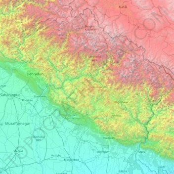
Name: Uttarakhand topographic map, elevation, terrain.

Location: Uttarakhand, India (28.71579 77.57133 31.45902 81.04479)

Average elevation: 6,896 ft

Minimum elevation: 525 ft

Maximum elevation: 24,416 ft

Other topographic maps

Click on a map to view its topography, its elevation and its terrain.

Machhor

India > Uttarakhand > Molekhal > Masord

Average elevation: 4,347 ft

Gamshali

India > Uttarakhand > Joshimath Tehsil

Average elevation: 12,546 ft

Gaurikund

India > Uttarakhand > Ukhimath

Average elevation: 8,494 ft

Jashuda

India > Uttarakhand > Pati

Average elevation: 5,627 ft

Gangotri

India > Uttarakhand > Bhatwari

Average elevation: 13,579 ft

Brahmkhal

India > Uttarakhand > Dunda

Average elevation: 5,033 ft

Sattal

India > Uttarakhand > Nainital

Average elevation: 4,334 ft

Chopta

India > Uttarakhand > Thailisain

Average elevation: 6,302 ft

Bameta Bangar Kheema

India > Uttarakhand > Lalkuan

Average elevation: 968 ft

dhanaula

India > Uttarakhand > Dehradun

Average elevation: 3,317 ft

Dugadda

India > Uttarakhand > Kotdwara

Average elevation: 2,940 ft

Uthind

India > Uttarakhand > Ukhimath

Average elevation: 5,253 ft

Gangolihāt

India > Uttarakhand > Gangolihat

Gangolihat is located at 29°29′N 80°03′E / 29.48°N 80.05°E / 29.48; 80.05. It has an average elevation of 1,760 metres (5,773 feet). It is 78 km from Pithoragarh. The main town is at a hill top. The region is surrounded by two rivers Saryu and Ramganga. Which meet at Ghat at the foothill of…

Average elevation: 5,026 ft

Kainchi

India > Uttarakhand > Kosya Kutauli

Average elevation: 5,495 ft

Benital

India > Uttarakhand > Karnaprayag

Average elevation: 6,070 ft

Garur

India > Uttarakhand > Garud

Average elevation: 4,035 ft

Chandrashila

India > Uttarakhand > Pokhari > Bhulkhana Chatti

Average elevation: 10,236 ft

Sitapur

India > Uttarakhand > Ukhimath

Average elevation: 6,765 ft

Lambgaon

India > Uttarakhand > Pratapnagar

Average elevation: 4,911 ft

Sahastradhara

India > Uttarakhand > Dehradun

Average elevation: 3,609 ft

Budha Kedar

India > Uttarakhand > Ghansali

Average elevation: 5,394 ft

Ghuttu

India > Uttarakhand > Ghansali

Average elevation: 6,089 ft

Roorkee

India > Uttarakhand > Roorkee

Roorkee is located at 29°52′N 77°53′E / 29.87°N 77.88°E / 29.87; 77.88. It has an average elevation of 268 metres (879 ft).

Average elevation: 886 ft

Lakhani

India > Uttarakhand > Garud

Average elevation: 4,718 ft

Modera

India > Uttarakhand > Joshimath Tehsil

Average elevation: 9,452 ft

Dewal

India > Uttarakhand > Karnaprayag

Average elevation: 6,033 ft

Dwara

India > Uttarakhand > Pokhari > Pokhri

Average elevation: 5,148 ft

Mohanpur

India > Uttarakhand > Dehradun > Dehradun

Average elevation: 1,965 ft

Dharkot

India > Uttarakhand > Chinyali Saur > Banchoura

Average elevation: 4,902 ft

Mana

India > Uttarakhand > Joshimath Tehsil

Average elevation: 16,270 ft

dhargaon

India > Uttarakhand > Srinagar > Srinagar

Average elevation: 2,776 ft

Tehri Dam

India > Uttarakhand > Tehri > Bhagirathipuram

Average elevation: 2,969 ft

Raura

India > Uttarakhand > Chakrata

Average elevation: 5,249 ft

Bhimtal

India > Uttarakhand > Nainital

Average elevation: 4,783 ft

Sankri

India > Uttarakhand > Pokhari

Average elevation: 4,721 ft

Doiwāla

India > Uttarakhand > Dehradun

Average elevation: 1,591 ft

ranichauri

India > Uttarakhand > Tehri > Sabli

Average elevation: 5,295 ft

binsar

India > Uttarakhand > Bageshwar > Bāgeshwar

Average elevation: 4,875 ft

Chinyalisaur

India > Uttarakhand > Chinyali Saur

Average elevation: 4,272 ft

Mukteshwar

India > Uttarakhand > Dhari

Average elevation: 6,503 ft

Uttarkashi

India > Uttarakhand > Bhatwari

It is the district headquarters of Uttarkashi district. Uttarkashi is situated on the banks of river Bhagirathi at an altitude of 1158 m above sea level. Uttarkashi is generally known as a holy town close to Rishikesh. It is located in the state of Uttarakhand in India. Uttarkashi is home to a number of…

Average elevation: 5,312 ft

Sariyatal

India > Uttarakhand > Nainital > Char Khet > Sariya

Average elevation: 6,161 ft

Nakuri

India > Uttarakhand > Garud

Average elevation: 5,351 ft

Chopta

India > Uttarakhand > Tharali

Average elevation: 4,682 ft

Mussoorie

India > Uttarakhand > Dehradun

Mussoorie is at an average altitude of 2,005 metres (6,578 ft). To the northeast are the Himalayan snow ranges, and to the south, the Doon Valley and Shiwalik ranges. The second highest point is the original Lal Tibba in Landour, with a height of over 2,275 m (7,464 ft). Mussoorie is popularly known as The…

Average elevation: 5,230 ft

bhayun

India > Uttarakhand > Kapkot

Average elevation: 4,193 ft

Matiyal

India > Uttarakhand > Dhari

Average elevation: 5,663 ft

Gangotri Glacier

India > Uttarakhand > Bhatwari

Average elevation: 17,254 ft

Kumaon

India > Uttarakhand > Kosya Kutauli > Rāmgarh > Kumaon

Average elevation: 6,457 ft

Kulsari

India > Uttarakhand > Chaukhutiya > Kulsari

Average elevation: 5,525 ft

Khoi

India > Uttarakhand > Kalsi > Chandau

Average elevation: 4,390 ft

Badrinath

India > Uttarakhand > Joshimath Tehsil

Average elevation: 13,294 ft

Harsil

India > Uttarakhand > Bhatwari

Average elevation: 9,058 ft

Dharali

India > Uttarakhand > Bhatwari > Dharali

Average elevation: 9,721 ft

Haldwani

India > Uttarakhand > Haldwani > Haldwani

Average elevation: 2,208 ft

Dawar

India > Uttarakhand > Chamoli Tehsil > Dawar

Average elevation: 5,276 ft

Kedarnath

India > Uttarakhand > Ukhimath

Average elevation: 13,806 ft

Shilla

India > Uttarakhand > Bhatwari

Average elevation: 7,146 ft

Khir Ganga

India > Uttarakhand > Kapkot > bhayun

Average elevation: 5,184 ft

Chaurangikhal

India > Uttarakhand > Dunda > Chaurangikhal

Average elevation: 7,441 ft

Bāgeshwar

India > Uttarakhand > Bāgeshwar

Average elevation: 3,786 ft

Kasar Devi

India > Uttarakhand > Kasar Devi

Average elevation: 5,075 ft

Maiktoli

India > Uttarakhand

Average elevation: 19,518 ft

Nigalpani

India > Uttarakhand > Nigalpani

Average elevation: 4,114 ft

Dhana

India > Uttarakhand > Kaladhungi

Average elevation: 1,873 ft

Thai

India > Uttarakhand > Tharali

Average elevation: 5,919 ft

Sabra

India > Uttarakhand > Tyuni > Sabra

Average elevation: 5,062 ft