
Bihar topographic map
Click on the map to display elevation.
Bihar
Bihar covers a total area of 94,163 km2 (36,357 sq mi), with an average elevation above sea level of 173 feet (53 m). It is land locked by Nepal in the north, Jharkhand in the south West Bengal in the east and Uttar Pradesh to the west. It has three parts on the basis of physical and structural conditions: the Southern Plateau, the Shivalik Region, and Bihar's Gangetic Plain. Furthermore, the vast stretch of fertile Bihar Plain is divided by the Ganges River into two unequal parts – North Bihar and South Bihar. The Ganges flows west–east and, along with its tributaries, regularly floods parts of the Bihar plain. The main northern tributaries are the Gandak and Koshi, which originate in the Nepalese Himalayas, and the Bagmati, which originates in the Kathmandu Valley. Other tributaries are the Son, Budhi Gandak, Chandan, Orhani and Phalgu. Bihar has some small hills, such as the Rajgir hills in center, Kaimur Range in south-west and Shivalik Range in North. Bihar has notified forest area of 6,764.14 km2, which is 7.1 percent of its geographical area. The sub-Himalayan foothills of Shivalik ranges, primary Someshwar and Dun mountain, in West Champaran district are clad in a belt of moist deciduous forest. As well as trees, this consists of scrub, grass and reeds.
About this map
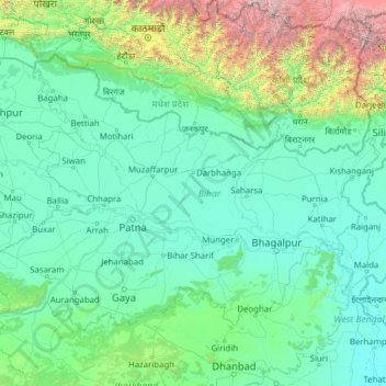
Name: Bihar topographic map, elevation, terrain.
Location: Bihar, India (24.28572 83.32126 27.52164 88.29380)
Average elevation: 1,985 ft
Minimum elevation: 39 ft
Maximum elevation: 26,621 ft
Other topographic maps
Click on a map to view its topography, its elevation and its terrain.
Khanapur
India > Karnataka > Khanapura taluku
Khanapur has an elevation of 646 metres (2,119 ft).
Average elevation: 2,192 ft
Sakleshpur
India > Karnataka > Sakaleshapura taluk
Sakleshpur is located at 12°53′35″N 75°43′30″E / 12.893°N 75.725°E / 12.893; 75.725. It has an average elevation of 932 m (3,058 ft) above mean sea level.
Average elevation: 3,031 ft
Durgapur
India > West Bengal > Faridpur Durgapur
Durgapur is located at 23°33′N 87°19′E / 23.55°N 87.32°E / 23.55; 87.32. It has an average elevation of 65 metres (213 ft).
Average elevation: 249 ft
Amarkantak
India > Madhya Pradesh > Pushparajgarh Tehsil
Amarkantak is located in Madhya Pradesh in India at 22°40′N 81°45′E / 22.67°N 81.75°E / 22.67; 81.75. It has an average elevation of 1,048 m (3,438 ft). Roads running through Rewa, Shahdol, Anuppur, Jabalpur, Katni, Bilaspur and Gaurella connect it. The nearest railway stations are Pendra Road…
Average elevation: 2,900 ft
Matheran
India > Maharashtra > Karjat
Matheran is an automobile-free hill station and a municipal council in the Karjat taluka of the Raigad district located in the Indian state of Maharashtra. Matheran is part of the Mumbai Metropolitan Region, and one of the smallest hill stations in India. It is located in the Western Ghats, at an elevation of…
Average elevation: 1,066 ft
Bengaluru
India > Karnataka > Bangalore North
Bangalore (/ˈbæŋɡəlɔːr, ˌbæŋɡəˈlɔːr/ BANG-gə-lor, -LOR), officially Bengaluru (Kannada: [ˈbeŋɡɐɭuːɾu] ; ISO: Beṁgaḷūru), is the capital and largest city of the southern Indian state of Karnataka. It has a population of more than 8 million and a metropolitan population of around…
Average elevation: 2,884 ft
Kolar
India > Karnataka > Kolar taluk
Kolar is located at 13°08′N 78°08′E / 13.13°N 78.13°E / 13.13; 78.13. with an average elevation of 849 metres (2,785 ft).
Average elevation: 2,779 ft
Alangulam
India > Tamil Nadu > Alangulam
Alangulam is located at 8°52′N 77°30′E / 8.87°N 77.5°E / 8.87; 77.5. It is situated at an average elevation of 127 metres (416 feet).
Average elevation: 394 ft
Adimali
Adimaly generally has a cool climate throughout the year, typical of the higher altitudes, though not as cold as Munnar. Temperatures rarely exceed 26 degrees and never drop below 10 degrees as it usually stays around 17-24 degrees. Though December–January are comparatively cooler than other months. Adimaly…
Average elevation: 2,579 ft
Ujjain
India > Madhya Pradesh > Ujjain NagarTahsil
Ujjain is located in the west-central part of India, and is north of the upper limit of the Vindhya mountain ranges. Located on the Malwa plateau, it is higher than the north Indian plains and the land rises towards the Vindhya Range to the south. Ujjain's coordinates are 23°10′N 75°46′E /…
Average elevation: 1,644 ft
Harapanahalli
India > Karnataka > Harapanahalli taluku
It has an average elevation of 633 metres (2076 feet) away from the sea level. Harapanahalli is surrounded by several districts like Davanagere in the South, Chithradurga in the Southeast, Haveri in the West. Harapanahalli had operated under Bellari, Davanagere districts and Now it is operating under…
Average elevation: 2,054 ft
Jajpur
Jajpur is located at 20°51′N 86°20′E / 20.85°N 86.33°E / 20.85; 86.33 and has an average elevation of 8 metres (26 ft). The climate of Jajpur District is normal as per Indian standards. All the seasons arrive in the District at their usual time. The District's average height from the sea level…
Average elevation: 46 ft
Krishnanagar
India > West Bengal > Krishnagar-I
Krishnanagar is located at 23°24′N 88°30′E / 23.4°N 88.5°E / 23.4; 88.5. The area of the municipality is around 16 km2. It is situated on the southern banks of the Jalangi River. It has an average elevation of 14 metres (46 ft). The Tropic of Cancer passes through the outskirts of…
Average elevation: 36 ft
Roorkee
India > Uttarakhand > Roorkee
Roorkee is located at 29°52′N 77°53′E / 29.87°N 77.88°E / 29.87; 77.88. It has an average elevation of 268 metres (879 ft).
Average elevation: 886 ft
Cherrapunji (Sohra)
India > Meghalaya > Shella Bholaganj > Cherrapunji (Sohra)
It has an average elevation of 1,430 metres (4,690 ft) and sits on a plateau in the southern part of the Khasi Hills, facing the plains of Bangladesh. The plateau rises 660 meters above the surrounding valleys.
Average elevation: 4,094 ft
Lachung
India > Sikkim > Chungthang
Lachung is a town and hill station in northeast Sikkim, India. It is located in the North Sikkim district near the border with Tibet. Lachung is at an elevation of about 9,600 feet (2,900 m) and at the confluence of the Lachen and Lachung Rivers, both tributaries of the River Teesta. The word Lachung means…
Average elevation: 11,867 ft
Moodabidri
India > Karnataka > Moodabidri taluk
Its average elevation is 147 metres (482 ft).
Average elevation: 364 ft
Gangtok
Gangtok (Nepali: [gantok] gāntok, Sikkimese: [ɡaŋt̪ʰòk]) is the capital and the most populous city of the Indian state of Sikkim. The seat of eponymous district, Gangtok is in the eastern Himalayan range, at an elevation of 1,650 m (5,410 ft). The city's population of 100,000 consists of the three…
Average elevation: 6,270 ft
Arambagh
India > West Bengal > Arambag
Arambagh is located at 22°53′N 87°47′E / 22.88°N 87.78°E / 22.88; 87.78. It has an average elevation of 15 metres (118 feet). The town is situated on the link Road (state highway-2) 81Km north-west of Kolkata, 27 Km north-west of Tarakeswar, 39 Km south-east of Bardhaman. It is located on the…
Average elevation: 56 ft
Tirupattur
India > Tamil Nadu > Tirupathur
Tirupathur is called "Sandalwood Town" due to the abundance of sandalwood trees in the surrounding hills. It is very close to the Yelagiri hills, a major hill station of Tamil Nadu. The town is at an average elevation of 388 m (1,273 ft). The Jawadhu Hills, a part of the eastern ghats, are to the east of…
Average elevation: 1,276 ft
Anand
India > Gujarat > Anand City Taluka
Anand is located at 22°34′N 72°56′E / 22.57°N 72.93°E / 22.57; 72.93. It has an average elevation of 39 m (128 ft). The city has an area of 47.89 km2 (18.49 sq mi).
Average elevation: 131 ft
Guntakal
India > Andhra Pradesh > Guntakal
Guntakal is located at 15°10′N 77°23′E / 15.17°N 77.38°E / 15.17; 77.38. It has an average elevation of 432 metres (1,417 ft).
Average elevation: 1,460 ft
Pasighat
India > Arunachal Pradesh > Pasighat HQ
Pasighat is located at 28°04′N 95°20′E / 28.07°N 95.33°E / 28.07; 95.33. It has an average elevation of 153 metres or 502 feet. Pasighat has a typical lowland Northeast India humid subtropical climate (Köppen Cwa) a little too cool to qualify as a tropical monsoon climate (Am).
Average elevation: 587 ft
Baralacha Pass
India > Himachal Pradesh > Lahul
"The Bara Lacha is the boundary between two separate regions distinguished by their physical characteristics. That which we have already passed through may be called the true Himalayan region. Here the gigantic ranges are covered with perpetual snow, furrowed by glaciers, and they arise from amid dense forests…
Average elevation: 16,348 ft
Hosur
India > Tamil Nadu > Hosur > Hosur
Hosur experiences a tropical savanna climate (Köppen climate classification) with distinct wet and dry seasons. Due to its high elevation, Hosur usually enjoys salubrious and moderate climate throughout the year, with occasional heat waves. The coolest month is January with an average low temperature of 17.1…
Average elevation: 2,818 ft
Chittaranjan
India > West Bengal > Salanpur
Chittaranjan is located at 23°52′N 86°52′E / 23.87°N 86.87°E / 23.87; 86.87. It has an average elevation of 155 metres (508 feet).
Average elevation: 512 ft
Barren Island
India > Andaman and Nicobar Islands
This volcanic island stands in the midst of a volcanic belt on the edge of the Indian and Burmese tectonic plates. Narcondam Island is a dormant volcano in the area, apart from volcanic seamounts like Alcock and Sewell. All the historical and recent eruptions (1789 and after) are confined within and around an…
Average elevation: 354 ft
Dakshina Kannada
The topography of the district is plain up to 30 km (18.64 mi) inside the coast and changes to undulating hilly terrain sharply towards the east in the Western Ghats. Teak, bamboo and rosewood trees are found in the hilly areas towards the east. The Geological Survey of India has identified this district as a…
Average elevation: 358 ft
Jadcherla
India > Telangana > Jadcherla mandal
Jadcherla is located at 16°46′26″N 78°08′12″E / 16.7738°N 78.1367°E / 16.7738; 78.1367 and at an altitude of 14 m (46 ft). The town is spread over an area of 550 km2 (210 sq mi). Jadcherla is located 86 km from Hyderabad 130km from Kurnool and 21 km from Mahabubnagar.
Average elevation: 1,811 ft
Ratnagiri
India > Maharashtra > Ratnagiri
Ratnagiri is located at 16°59′N 73°18′E / 16.98°N 73.3°E / 16.98; 73.3. It has an average elevation of 11 meters (36 feet). The Sahyadri mountains border Ratnagiri to the east
Average elevation: 98 ft
Pavagada
India > Karnataka > Pavagada taluk
Pavagada is located at 14°06′N 77°16′E / 14.1°N 77.27°E / 14.1; 77.27. It has an average elevation of 646 metres (2,119 feet).
Average elevation: 2,110 ft
Nathu La
Nathu La is a mountain pass on the Dongkya Range that separates Sikkim and the Chumbi Valley at an elevation of 14,250 feet (4,340 m). The pass is 52–54 kilometres (32–34 mi) east of Gangtok, the capital of Sikkim, and 35 kilometres (22 mi) from Yatung Shasima, the headquarters of the Yadong County (or the…
Average elevation: 13,911 ft
Omalur
India > Tamil Nadu > Omalur
Omalur is located at 11°44′N 78°04′E / 11.73°N 78.07°E / 11.73; 78.07. It has an average elevation of 298 metres (977 feet).
Average elevation: 912 ft
Ponmudi
India > Kerala > Nedumangad
Ponmudi (the Golden Peak) is a hill station in the Peringamala gramapanchayath of Thiruvananthapuram district of Kerala in India. It is located 22km west of Vithura town, 53 km north-east of Thiruvananthapuram City, 78 km south-east of Varkala town and 69 km north-east of Kovalam Beach at an altitude of 1,100…
Average elevation: 2,208 ft