
Ozark County topographic map
Click on the map to display elevation.
About this map
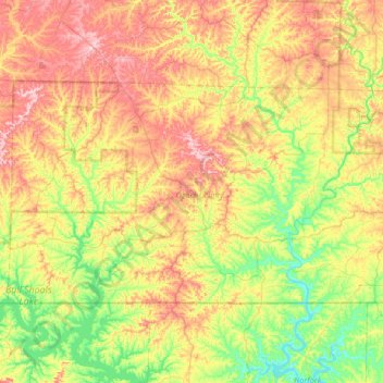
Name: Ozark County topographic map, elevation, terrain.
Location: Ozark County, Missouri, United States (36.49720 -92.77433 36.80602 -92.11247)
Average elevation: 919 ft
Minimum elevation: 531 ft
Maximum elevation: 1,480 ft
Missouri trails, hiking, mountain biking, running and outdoor activities
Other topographic maps
Click on a map to view its topography, its elevation and its terrain.
Mississippi & Missouri River Confluence Point
United States > Missouri > Saint Charles County > West Alton
Average elevation: 413 ft
Elephant Rocks State Park
United States > Missouri > Iron County > Graniteville
Average elevation: 1,227 ft
Richard L. Berkley Riverfront Park
United States > Missouri > Jackson County > Kansas City
Average elevation: 794 ft
Little Lost Creek Conservation Area
United States > Missouri > Warren County > Pendleton
Average elevation: 791 ft