
Randolph County topographic map
Click on the map to display elevation.
About this map
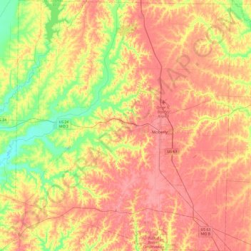
Name: Randolph County topographic map, elevation, terrain.
Location: Randolph County, Missouri, United States (39.24666 -92.70832 39.61108 -92.30257)
Average elevation: 791 ft
Minimum elevation: 636 ft
Maximum elevation: 909 ft
Missouri trails, hiking, mountain biking, running and outdoor activities
Other topographic maps
Click on a map to view its topography, its elevation and its terrain.
Creve Coeur Lake
United States > Missouri > Saint Louis County > Maryland Heights
Average elevation: 492 ft
Mountain Grove
United States > Missouri > Wright County > Mountain Grove > Mountain Grove
This became known as the "mountain store, mountain grove or the mountain" due to its elevation of 1,525 feet (465 m). One of the most famous incidents in Mountain Grove occurred in the middle of May 1883, when what was called a "nipping frost" caused every tree, sapling and shrub in the community of Fyan and…
Average elevation: 1,430 ft
Lee's Summit
United States > Missouri > Jackson County > Lee's Summit
When the surveyors for the Missouri Pacific Railroad came through, the local people and the railroad wanted to name the town in Dr. Lea's honor. He had a farm on the highest point and near the path of the tracks, and his murder had taken place near the site of the proposed depot. So they chose the name of…
Average elevation: 945 ft
Jackson
United States > Missouri > Cape Girardeau County > Jackson > Jackson
Average elevation: 482 ft
Pacific Palisades Conservation Area
United States > Missouri > Jefferson County
Average elevation: 499 ft
Dearborn Reservoir Dam
United States > Missouri > Buchanan County > Dearborn
Average elevation: 948 ft
Lake Saint Clair Number Three Dam
United States > Missouri > Franklin County
Average elevation: 705 ft