
Saint Charles County topographic map
Click on the map to display elevation.
Saint Charles County
Saint Charles County features a gently rolling topography characterized by elevations that generally range from about 400 to 700 feet above sea level. The landscape gradually rises from the Missouri River, which forms the county's eastern boundary. This elevation gradient creates a diverse terrain that includes open fields, wooded areas, and residential developments interspersed throughout the region. The area is also dotted with numerous parks and green spaces, enhancing its natural beauty and providing ample opportunities for outdoor activities. Several creeks and tributaries weave through the landscape, contributing to the region's ecological richness and offering scenic views for residents and visitors alike.
About this map
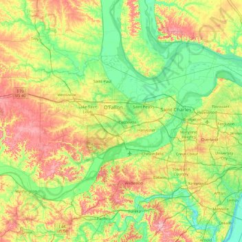
Name: Saint Charles County topographic map, elevation, terrain.
Location: Saint Charles County, Missouri, United States (38.53429 -90.96445 38.96764 -90.10774)
Average elevation: 571 ft
Minimum elevation: 377 ft
Maximum elevation: 942 ft
Missouri trails, hiking, mountain biking, running and outdoor activities
Other topographic maps
Click on a map to view its topography, its elevation and its terrain.
Mississippi & Missouri River Confluence Point
United States > Missouri > Saint Charles County > West Alton
Average elevation: 413 ft
Elephant Rocks State Park
United States > Missouri > Iron County > Graniteville
Average elevation: 1,227 ft
Richard L. Berkley Riverfront Park
United States > Missouri > Jackson County > Kansas City
Average elevation: 794 ft
Little Lost Creek Conservation Area
United States > Missouri > Warren County > Pendleton
Average elevation: 791 ft