
Carson County topographic map
Click on the map to display elevation.
About this map
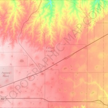
Name: Carson County topographic map, elevation, terrain.
Location: Carson County, Texas, United States (35.18168 -101.62311 35.62527 -101.08595)
Average elevation: 3,363 ft
Minimum elevation: 2,940 ft
Maximum elevation: 3,602 ft
Texas trails, hiking, mountain biking, running and outdoor activities
Other topographic maps
Click on a map to view its topography, its elevation and its terrain.
Austin
United States > Texas > Travis County
The elevation of Austin varies from 425 feet (130 m) to approximately 1,000 feet (305 m) above sea level. Due to the fact it straddles the Balcones Fault, much of the eastern part of the city is flat, with heavy clay and loam soils, whereas the western part and western suburbs consist of rolling hills on the…
Average elevation: 666 ft
Dallas
United States > Texas > Dallas County
Dallas and its surrounding area are mostly flat. The city lies at elevations ranging from 450 to 550 feet (137 to 168 m) above sea level. The western edge of the Austin Chalk Formation, a limestone escarpment (also known as the "White Rock Escarpment"), rises 230 feet (70 m) and runs roughly north–south…
Average elevation: 518 ft
Horseshoe Bay
United States > Texas > Llano County > Horseshoe Bay > Horseshoe Bay
Average elevation: 938 ft
Levelland
United States > Texas > Hockley County
Levelland became the county seat upon its organization in 1921. Initially named Hockley City by Charles W. Post in 1912, development began in 1921, and the town was swiftly renamed for its local topography. The town's foundation was further solidified with the commencement of Santa Fe Railroad service in July…
Average elevation: 3,520 ft
Marfa
United States > Texas > Presidio County
Marfa is a city in the high desert of the Trans-Pecos in far West Texas, United States, between the Davis Mountains and Big Bend National Park, at an elevation of 4685 feet. It is the county seat of Presidio County, and its population as of the 2020 United States Census was 1,788. The city was founded in the…
Average elevation: 4,705 ft
Franklin Mountains State Park
United States > Texas > El Paso County > El Paso
Franklin Mountains State Park is a Texas state park in El Paso, Texas, that protects the Franklin Mountains. Park headquarters are located at an elevation of 5,426 feet (1,654 m) with the highest peak, North Franklin Mountain, reaching 7,192 feet (2,192 m). It is one of the largest urban parks in the nation…
Average elevation: 4,242 ft
Fredericksburg
United States > Texas > Gillespie County
Enchanted Rock is a geographical landmark 27 km (17 mi) north of Fredericksburg in Llano County. The rock is a huge, pink granite exfoliation dome that rises 425 ft (130 m) above the surrounding land, has a summit elevation of 1,825 ft (556 m) above sea level, and covers 640 acres (260 ha). Enchanted Rock…
Average elevation: 1,726 ft
Royse City
United States > Texas > Rockwall County > Royse City > Royse City
Average elevation: 558 ft
Amarillo
United States > Texas > Potter County
Extreme temperatures range from −16 °F (−26.7 °C) on February 12, 1899 to 111 °F (43.9 °C) on June 26, 2011, but lows do not typically dip to 0 °F or −17.8 °C in most years, while highs above 100 °F or 37.8 °C are seen on 4.7 days on average. On average, there are 5.9 days of lows at or below 10…
Average elevation: 3,599 ft
Midkiff
United States > Texas > Upton County
Midkiff is a T-shaped unincorporated desert village in northeastern Midland County, Texas, United States. It lies along RM 2401 and FM 3095, north of the city of Rankin, the county seat of Upton County. Its elevation is 2,736 feet (834 m). It has a post office, serving the ZIP code of 79755; the ZCTA for ZIP…
Average elevation: 2,730 ft
Elbow
United States > Texas > Howard County
The elevation is 2,549 feet (777 m).
Average elevation: 2,556 ft