Geolocate

Slipdown Mountain topographic map

Click on the map to display elevation.

About this map

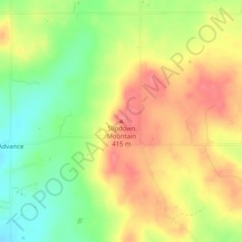
Name: Slipdown Mountain topographic map, elevation, terrain.

Location: Slipdown Mountain, Parker County, Texas, United States (32.94396 -97.91259 32.94406 -97.91249)

Average elevation: 1,280 ft

Minimum elevation: 1,158 ft

Maximum elevation: 1,378 ft

Texas trails, hiking, mountain biking, running and outdoor activities

Other topographic maps

Click on a map to view its topography, its elevation and its terrain.

Port Aransas

United States > Texas > Nueces County

Average elevation: 3 ft

Bulverde

United States > Texas > Comal County

Average elevation: 1,194 ft

Liberty Hill

United States > Texas > Williamson County

Average elevation: 1,040 ft

Spring Branch

United States > Texas > Comal County

Average elevation: 1,142 ft

Big Bend National Park

United States > Texas > Brewster County

Big Bend National Park is an American national park located in West Texas, bordering Mexico. The park has national significance as the largest protected area of Chihuahuan Desert topography and ecology in the United States, and was named after a large bend in the Rio Grande/Río Bravo. The park protects more…

Average elevation: 3,064 ft

Lamb County

United States > Texas

Average elevation: 3,632 ft

Aransas County

United States > Texas

Average elevation: 7 ft

Lavon Lake

United States > Texas > Collin County > Wylie

Average elevation: 545 ft

Carson County

United States > Texas

Average elevation: 3,363 ft

Lake Granbury

United States > Texas > Hood County > Brazos Bend

Average elevation: 817 ft

Santa Fe

United States > Texas > Galveston County

Average elevation: 26 ft

Aransas Pass

United States > Texas > San Patricio County

Average elevation: 13 ft

Point Venture

United States > Texas > Travis County

Average elevation: 719 ft

Celina

United States > Texas > Collin County

Average elevation: 686 ft

Hartley County

United States > Texas

Average elevation: 3,907 ft

Ingleside

United States > Texas > San Patricio County

Average elevation: 16 ft

Donley County

United States > Texas

Average elevation: 2,667 ft

Moody

United States > Texas > McLennan County

Average elevation: 771 ft

Uvalde

United States > Texas > Uvalde County

Average elevation: 919 ft

Caddo Mills

United States > Texas > Hunt County

Average elevation: 528 ft

New Braunfels

United States > Texas > Comal County

Average elevation: 748 ft

Scurry County

United States > Texas

Since 1952, Lake J. B. Thomas has operated in Scurry County covering up to 7,282 acres when filled to the morning glory spillway at elevation of 2,258 ft above sea level.

Average elevation: 2,359 ft

Amherst

United States > Texas > Lamb County

Average elevation: 3,648 ft

Bosque County

United States > Texas

Average elevation: 869 ft

Nurse

United States > Texas > Erath County > Stephenville

Average elevation: 1,329 ft

Salado

United States > Texas > Bell County

Average elevation: 643 ft

Palmview

United States > Texas > Hidalgo County

Average elevation: 141 ft

Columbus

United States > Texas > Colorado County

Average elevation: 200 ft

Terrell

United States > Texas > Kaufman County

Average elevation: 502 ft

Eastland County

United States > Texas

Average elevation: 1,526 ft

Canyon Lake Dam

United States > Texas > Comal County

Average elevation: 902 ft

Blossom

United States > Texas > Lamar County

Average elevation: 545 ft

Lake Austin

United States > Texas > Travis County > Austin

Average elevation: 794 ft

Trinity

United States > Texas > Trinity County

Average elevation: 213 ft

Weatherford

United States > Texas > Parker County

Average elevation: 1,070 ft

Jacksonville

United States > Texas > Cherokee County

Average elevation: 499 ft

Marfa

United States > Texas > Presidio County

Marfa is a city in the high desert of the Trans-Pecos in far West Texas, United States, between the Davis Mountains and Big Bend National Park, at an elevation of 4685 feet. It is the county seat of Presidio County, and its population as of the 2020 United States Census was 1,788. The city was founded in the…

Average elevation: 4,705 ft

Groesbeck

United States > Texas > Limestone County

Average elevation: 456 ft

Rising Star

United States > Texas > Eastland County

Average elevation: 1,650 ft

Reklaw

United States > Texas > Cherokee County

Average elevation: 305 ft

Sewell Park

United States > Texas > Hays County > San Marcos

Average elevation: 630 ft

Maypearl

United States > Texas > Ellis County

Average elevation: 574 ft

Deep Ellum PID

United States > Texas > Dallas County > Dallas

Following World War II, the success of Deep Ellum started to fade. The ever-growing availability and use of the automobile led to the removal of the Houston and Texas Central railroad tracks—to make way for Central Expressway—and by 1956 the streetcar line had been removed. Businesses closed, residents…

Average elevation: 476 ft

Cresson

United States > Texas > Hood County

Average elevation: 994 ft

Concepcion Park

United States > Texas > Bexar County > San Antonio

Average elevation: 620 ft

Thrall

United States > Texas > Williamson County

Average elevation: 538 ft

New Chapel Hill

United States > Texas > Smith County

Average elevation: 453 ft

Menard Park

United States > Texas > Galveston County > Galveston

Average elevation: 13 ft

Blanco State Park

United States > Texas > Blanco County > Blanco

Average elevation: 1,368 ft

Lewisville Lake

United States > Texas > Denton County > Oak Point

Average elevation: 554 ft

Godley

United States > Texas > Johnson County

Average elevation: 942 ft

Westbrook

United States > Texas > Mitchell County

Average elevation: 2,156 ft

Indian Creek

United States > Texas > Fannin County > Trenton

Average elevation: 755 ft

Sanctuary

United States > Texas > Parker County

Average elevation: 781 ft

Graham

United States > Texas > Young County

Average elevation: 1,089 ft

Lipscomb County

United States > Texas

Average elevation: 2,589 ft

Bastrop

United States > Texas > Bastrop County

Average elevation: 423 ft

Blanket

United States > Texas > Brown County

Average elevation: 1,644 ft

Chimney Rock Park

United States > Texas > Harris County > Houston

Average elevation: 69 ft

Seagraves

United States > Texas > Gaines County

Average elevation: 3,353 ft

San Jacinto River

United States > Texas > Harris County

Average elevation: 3 ft

Jim Hogg County

United States > Texas

Average elevation: 531 ft

Lake Alan Henry

United States > Texas > Garza County

Lake Alan Henry is located on the Double Mountain Fork Brazos River in West Texas. South of Lubbock and east of Justiceburg, the lake extends 11 mi (18 km) and has over 56 mi (90 km) of shoreline. Its elevation is 1,000 ft (300 m) lower than the city of Lubbock. Lake Alan Henry has a maximum depth of 100 ft…

Average elevation: 2,320 ft

Junction

United States > Texas > Kimble County

Average elevation: 1,745 ft

San Saba

United States > Texas > San Saba County

Average elevation: 1,283 ft

Stagecoach

United States > Texas > Montgomery County

Average elevation: 213 ft

Cochran County

United States > Texas

Average elevation: 3,789 ft

Flag Pole Hill Park

United States > Texas > Dallas County > Dallas

Average elevation: 515 ft

Cleburne

United States > Texas > Johnson County

Average elevation: 820 ft

Knox City

United States > Texas > Knox County

Average elevation: 1,539 ft

Lorena

United States > Texas > McLennan County

Average elevation: 610 ft

Pyote

United States > Texas > Ward County

Average elevation: 2,635 ft

Calvert

United States > Texas > Robertson County

Average elevation: 338 ft

Hamilton Pool

United States > Texas > Travis County

Average elevation: 902 ft

Ames

United States > Texas > Liberty County

Average elevation: 66 ft

Novice

United States > Texas > Coleman County

Average elevation: 1,988 ft

Webster

United States > Texas > Harris County

Average elevation: 23 ft

Llano

United States > Texas > Llano County

Average elevation: 1,070 ft

Sudan

United States > Texas > Lamb County

Average elevation: 3,753 ft

Alto

United States > Texas > Cherokee County

Average elevation: 427 ft

Lake Houston

United States > Texas > Harris County > Houston

Average elevation: 66 ft

Lake Nasworthy

United States > Texas > Tom Green County > San Angelo

Average elevation: 1,896 ft

Spearman

United States > Texas > Hansford County

Average elevation: 3,097 ft

Happy

United States > Texas > Swisher County

Average elevation: 3,609 ft

Levelland

United States > Texas > Hockley County

Levelland became the county seat upon its organization in 1921. Initially named Hockley City by Charles W. Post in 1912, development began in 1921, and the town was swiftly renamed for its local topography. The town's foundation was further solidified with the commencement of Santa Fe Railroad service in July…

Average elevation: 3,520 ft

Lake Waco

United States > Texas > McLennan County > Waco

The average elevation of Lake Waco is held around 460 feet above sea level, with a typical fluctuation of 2–6 feet. Prior to the construction of the new dam, droughts and floods were common occurrences for the city of Waco. However, the new dam has proven to be the proper solution, as there has not been any…

Average elevation: 515 ft

Pace Bend Park

United States > Texas > Travis County

Average elevation: 735 ft

Natalia

United States > Texas > Medina County

Average elevation: 719 ft

Gear up for your next adventure:

📦Dry Bags Set - Waterproof storage for electronics and clothes
🧦Merino Wool Socks - Moisture-wicking, blister-preventing socks for long treks
🥤Water Filter Bottle - All‑in‑one filter bottle for safe hydration
🧥Waterproof Jacket for Hiking - Breathable and rugged rain jacket for outdoor excursions
🛰️Handheld GPS Units - Professional satellite navigators for precise backcountry mapping

As an Amazon Associate, this site earns from qualifying purchases at no extra cost to you.