
Europe topographic map
Interactive map
Click on the map to display elevation.
Europe
Europe's topography is characterized by a striking contrast between its rugged southern mountains and the expansive plains of the north. The continent is often described as a "peninsula of peninsulas," featuring major peninsulas like the Iberian, Italian, and Balkan, each with unique geological features. In the southern regions, mountain ranges such as the Alps and the Pyrenees rise dramatically, with elevations frequently exceeding 9,800 feet (3,000 meters). Moving northward, the terrain gradually descends into the Great European Plain, a vast lowland stretching from the Pyrenees in the west to the Ural Mountains in the east, where most elevations are below 1,640 feet (500 meters). This plain is interspersed with rolling hills and valleys, making it one of the most agriculturally productive areas in Europe, while also being historically significant due to its accessibility for trade and invasion. The northern regions, including Scandinavia and the British Isles, are marked by fjords and rugged uplands, contributing to a diverse and complex landscape across the continent.
About this map
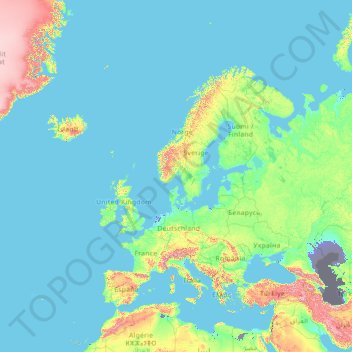
Name: Europe topographic map, elevation, terrain.
Location: Europe (26.00000 -15.00000 76.00000 35.00000)
Average elevation: 732 ft
Minimum elevation: -98 ft
Maximum elevation: 13,081 ft
Other topographic maps
Click on a map to view its topography, its elevation and its terrain.
Kerrville
United States > Texas > Kerr County
Kerrville is characterized by a diverse and rugged topography. Nestled along the Guadalupe River, it sits at an elevation averaging 1,600 feet above sea level, with varying terrain that includes gentle hills, steep slopes, and flat river valleys. This area features numerous limestone hills, characteristic of…
Average elevation: 1,788 ft
United States
The topography of the United States is characterized by diverse and dynamic landscapes that vary widely across the country. In the east, rolling hills and low mountains transition into the Appalachian Mountains, featuring peaks that generally reach around 6,000 feet (1,829 meters). Moving westward, the terrain…
Average elevation: 1,014 ft
Dallas
United States > Texas > Dallas County
Dallas features a predominantly flat terrain characterized by elevations generally ranging from 450 to 550 feet (137 to 168 meters) above sea level. The landscape is shaped significantly by the western edge of the Austin Chalk Formation, a limestone escarpment known as the White Rock Escarpment, which rises…
Average elevation: 525 ft
Texas
Texas showcases a diverse and expansive topography that spans approximately 268,000 square miles (694,117 Km²), making it the second-largest state in the United States. The landscape ranges from the arid deserts of West Texas, characterized by broad valleys and mesas, to the rolling hills of the Texas Hill…
Average elevation: 1,699 ft
Austin
United States > Texas > Travis County
Austin features a diverse and varied topography shaped by its position along the Balcones Fault. The city’s elevation ranges from about 425 feet to approximately 1,000 feet above sea level, creating a landscape characterized by rolling hills and elevated areas particularly in the western regions. To the…
Average elevation: 709 ft
Florida
Florida's topography is characterized by its predominantly flat landscape, with the highest elevation being Britton Hill at just 345 feet (105 meters) above sea level, making it the lowest high point of any U.S. state. The state is primarily divided into three physiographic regions: the Atlantic Coastal Plain,…
Average elevation: 20 ft
New York
New York City's topography is a fascinating blend of varied elevations and unique landscapes, reflecting its diverse geography across five boroughs. Situated at the confluence of the Hudson and East Rivers, the city primarily features low-lying terrain, with the average elevation hovering around sea level.…
Average elevation: 62 ft
Seattle
United States > Washington > King County
Seattle features a diverse topography characterized by its unique geographical setting between Puget Sound and Lake Washington. The city is situated on an isthmus, which contributes to its dramatic landscape, featuring rolling hills and steep slopes that rise abruptly from the waterfront. The average elevation…
Average elevation: 131 ft
Missouri
Missouri's topography is marked by a diverse array of landforms that contribute to its unique landscape. The state is characterized by four main physiographic regions: the Ozark Plateau, Dissected Till Plains, Mississippi Alluvial Plain, and the Osage Plains. The Ozark Plateau, located in the south, features…
Average elevation: 827 ft
Raleigh
United States > North Carolina > Wake County
Raleigh features a topography primarily defined by its position along the fall line, which is the geological boundary between the Piedmont and Coastal Plain regions. This area experiences a gradual elevation drop of approximately 150 to 350 feet over a distance of 1 to 3 miles as one moves eastward. The city's…
Average elevation: 338 ft
California
California's topography is characterized by a remarkable diversity that includes expansive mountain ranges, deep valleys, and vast deserts. The Sierra Nevada mountains dominate the eastern part of the state, with peaks such as Mount Whitney rising to 14,494 feet (4,418 meters), making it the tallest point in…
Average elevation: 3,048 ft
Colorado
Colorado's topography is characterized by a diverse range of elevations and landforms, making it one of the most geologically varied states in the U.S. The state is dominated by the Rocky Mountains, which run north to south and include the highest peak in the contiguous United States, Mount Elbert, towering at…
Average elevation: 6,759 ft
Denver
United States > Colorado > Denver County > Denver
Denver, situated at an elevation of 5,280 feet (1,609 meters), is renowned as the "Mile High City." It is located in the South Platte River Valley, just east of the Rocky Mountains' foothills. The city's topography features a gently sloping landscape characterized by rolling hills and wide valleys,…
Average elevation: 5,525 ft
San Francisco
San Francisco is characterized by its striking and varied topography, making it one of the most distinctive cities in the United States. The landscape features a mix of rolling hills and steep inclines, with the highest elevation reaching approximately 922 feet at Twin Peaks. The average elevation across the…
Average elevation: 207 ft
Portland
United States > Oregon > Multnomah County
Portland features a striking and varied topography characterized by its location at the confluence of the Willamette and Columbia Rivers. The city lies within the fertile Willamette Valley, flanked by the snow-capped Cascade Mountains to the east, including the prominent Mount Hood, and the less elevated…
Average elevation: 253 ft
Ruidoso
United States > New Mexico > Lincoln County
Ruidoso is in southern Lincoln County, with elevations ranging from 6,400 feet (2,000 m) at the village's southeast corner in the valley of the Rio Ruidoso up to over 7,700 feet (2,300 m) at the village's northern end near Alto. Ruidoso's southern border and westernmost border follow the Otero County line. The…
Average elevation: 7,503 ft
Arizona
Arizona's topography is highly diverse, shaped by three distinct regions: the Colorado Plateau, the Basin and Range Province, and the Transition Zone. The northern Colorado Plateau is characterized by flat, high plains over 4,000 feet in elevation, including the Grand Canyon and its breathtaking cliffs. In…
Average elevation: 4,032 ft
Saint Petersburg
United States > Florida > Pinellas County
Saint Petersburg features a predominantly flat topography characteristic of the Gulf Coast region. The city's elevation averages around 44 feet (approximately 13.4 meters) above sea level, with some areas dipping to about 15 feet (4.6 meters). This relatively low elevation contributes to the area's…
Average elevation: 13 ft
North Carolina
North Carolina features a diverse topography that can be divided into three distinct regions: the Coastal Plain, the Piedmont, and the Appalachian Mountains. The Coastal Plain, which occupies the eastern part of the state, is characterized by flat and gently sloping land, with elevations typically less than…
Average elevation: 535 ft
Atlanta
United States > Georgia > Fulton County
Atlanta features a varied topography characterized by its rolling hills and elevated terrain. The city sits at an average elevation of approximately 1,050 feet (320 meters) above sea level, with elevations ranging from about 725 feet (221 meters) to 1,175 feet (358 meters) in the surrounding areas. This…
Average elevation: 932 ft
Phoenix
United States > Arizona > Maricopa County
Phoenix is characterized by a unique topographical landscape nestled in the Salt River Valley. This valley, at an average elevation of about 1,086 feet, is framed by several prominent mountain ranges, creating a striking contrast between the flat plains and elevated terrains. Notable peaks such as Camelback…
Average elevation: 1,578 ft
Oregon
Oregon's topography is strikingly diverse, characterized by an array of geographical features that shape its unique landscape. The state is framed by two significant mountain ranges: the Pacific Coast Range to the west and the Cascade Mountains running north to south through the center. This mountainous…
Average elevation: 3,077 ft
Kansas City
United States > Missouri > Jackson County
Kansas City features a diverse topography characterized by rolling hills and valleys, with elevations ranging from about 794 to 997 feet above sea level. The landscape is shaped by the confluence of the Missouri and Kansas rivers, resulting in a mix of elevated areas and flat river plains. The region's average…
Average elevation: 909 ft
San Diego
United States > California > San Diego County
San Diego is characterized by a diverse topography that features coastal plains, rolling hills, and rugged mountain ranges. The city is situated along the Pacific Ocean, where it boasts an extensive shoreline with sandy beaches and tidal zones. As you move inland, the landscape transitions from the flat…
Average elevation: 410 ft
San Antonio
United States > Texas > Bexar County
San Antonio features a diverse topography characterized by gently rolling hills and flat plains. The city's elevation averages around 650 feet above sea level, but nearby areas can reach heights of up to 1,300 feet in certain locations like Cross Mountain. The landscape is part of the southern edge of the…
Average elevation: 810 ft
Philadelphia
United States > Pennsylvania > Philadelphia County
Philadelphia, located at the confluence of the Delaware and Schuylkill Rivers, features a diverse topography characterized by its gentle slopes and valleys. The city lies on the Atlantic Seaboard Fall Line, transitioning from the flat Coastal Plain to the more rugged Piedmont region. This unique geographical…
Average elevation: 144 ft
Pittsburgh
United States > Pennsylvania > Allegheny County
Pittsburgh, located in Allegheny County, Pennsylvania, is characterized by its distinct and varied topography, shaped by the confluence of the Allegheny, Monongahela, and Ohio rivers. The city itself is situated at an average elevation of approximately 764 feet (233 meters) above sea level, with the terrain…
Average elevation: 994 ft
Charlotte
United States > North Carolina > Mecklenburg County
Charlotte, located in the Piedmont region of North Carolina, features a gently rolling terrain characterized by elevations ranging from approximately 650 to 700 feet (198 to 213 meters). The city is bordered to the west by the Catawba River, which contributes to the area's mild climate and lush vegetation.…
Average elevation: 679 ft
Tennessee
Tennessee features a diverse and varied topography characterized by its distinct regions, which include the Appalachian Mountains, the Central Basin, and the Gulf Coastal Plain. The state’s highest point is Clingmans Dome, rising to about 6,643 feet (2,025 meters) above sea level, while the lowest point is…
Average elevation: 764 ft
Michigan
Michigan's topography is characterized by a diverse landscape that transitions from flat plains to rugged hills. The state comprises two peninsulas, with the Upper Peninsula showcasing more pronounced elevation changes, including its highest point, Mount Arvon, which rises to 1,979 feet (603 meters). In…
Average elevation: 850 ft
Nashville
United States > Tennessee > Davidson County
Nashville-Davidson, features a diverse topography characterized by its position in the Nashville Basin and the Highland Rim. The terrain is predominantly hilly, with elevations ranging from approximately 385 feet at the Cumberland River to around 1,163 feet in areas like Radnor Lake State Natural Area. This…
Average elevation: 604 ft
Ohio
Ohio's topography is characterized by a diverse landscape that ranges from the flat plains in the north to the rolling hills and rugged terrain in the southeast. The state can be divided into several distinct regions, including the Great Lakes Plains to the north, the Central Plains in the west, and the…
Average elevation: 912 ft
Tulsa
United States > Oklahoma > Tulsa County
Tulsa, located in northeastern Oklahoma, is characterized by a diverse and rolling topography that marks its transition from the Great Plains to the Ozark foothills. The city's elevation averages around 700 feet (approximately 210 meters) above sea level, with some areas reaching heights of up to 1,050 feet…
Average elevation: 725 ft
El Paso
United States > Texas > El Paso County
El Paso is characterized by a diverse and striking topography shaped by its desert environment and mountainous landscapes. The city is situated at an average elevation of approximately 3,700 feet above sea level, surrounded by the rugged Franklin Mountains to the west, where peaks exceed 7,000 feet. This…
Average elevation: 4,058 ft
Wisconsin
Wisconsin's topography is characterized by a diverse landscape shaped by glacial activity, resulting in a mixture of rolling hills, flat plains, and numerous lakes. The state’s highest point is Timms Hill, reaching an elevation of 1,952 feet (595 meters), while its lowest point is the shore of Lake Michigan…
Average elevation: 988 ft
Alabama
Alabama's topography is characterized by a diverse and intricate landscape that varies significantly across its regions. In the northern and northeastern parts, the terrain features the hilly and mountainous Appalachian Highlands, including the notable Cheaha Mountain, which rises to an elevation of 2,407 feet…
Average elevation: 446 ft
Tampa
United States > Florida > Hillsborough County
Tampa is characterized by a predominantly flat topography, with an average elevation around 16 to 49 feet (5 to 15 meters) above sea level. The terrain is marked by low-lying areas and gentle slopes, with the highest points in the vicinity reaching approximately 62 feet (19 meters). This landscape is…
Average elevation: 36 ft
Virginia
Virginia's topography is characterized by a diverse landscape that transitions from the Atlantic Coastal Plain in the east to the mountainous regions in the west. The Coastal Plain features flat, low-lying areas that gradually rise to the Piedmont, known for its rolling hills and valleys. Further west, the…
Average elevation: 814 ft
Chicago
United States > Illinois > Cook County
Chicago is characterized by its predominantly flat terrain, with an average elevation of about 579 feet (176 meters) above sea level. The city's landscape is primarily shaped by its proximity to Lake Michigan to the east, which influences local weather and provides a scenic waterfront. While the central areas…
Average elevation: 597 ft
Utah
Utah's topography is characterized by a stunning variety of landscapes, reflecting its geological complexity and rich natural history. The state is primarily shaped by the Colorado Plateau and the Basin and Range province, resulting in a diverse terrain that includes rugged mountain ranges, deep canyons, and…
Average elevation: 6,155 ft
Delaware
Delaware's topography is characterized by a distinctive blend of low-lying plains and gentle hills, reflective of its geographical positioning on the Atlantic Coastal Plain and the Appalachian Piedmont. The state predominantly features flat terrain, especially in its southern regions, where elevations rarely…
Average elevation: 52 ft
Minneapolis
United States > Minnesota > Hennepin County
Minneapolis is characterized by a diverse and dynamic topography. The city sits at an average elevation of approximately 830 feet (253 meters) above sea level, but this varies significantly across its landscape. The terrain is predominantly flat, interspersed with rolling hills, and is marked by the presence…
Average elevation: 886 ft
Boone
United States > North Carolina > Watauga County
Boone, located in Watauga County, North Carolina, is set within the rugged Appalachian Mountains, specifically the Blue Ridge range. With an elevation of approximately 3,300 feet (1,016 meters), it stands as one of the highest towns of its size in the eastern United States. The terrain is dominated by steep…
Average elevation: 3,507 ft
Orlando
United States > Florida > Orange County
Orlando features a predominantly flat terrain characterized by gentle hills and low-lying areas, with elevations typically ranging from 50 to 100 feet above sea level. Despite its overall flatness, the topography includes marshes and wetlands due to the presence of numerous lakes and rivers, contributing to a…
Average elevation: 98 ft
New Jersey
New Jersey's topography is characterized by a diverse landscape that ranges from coastal plains to rolling hills and rugged mountains. The state features a predominantly low elevation along its eastern coastline, where major cities like Newark and Jersey City are located. This coastal lowland, which includes…
Average elevation: 236 ft
Travis County
Travis County features a varied and dynamic topography characterized by rolling hills, lush valleys, and significant water features. The terrain rises gently from the flatlands in the east to the more rugged and elevated areas in the west, reaching elevations of up to about 1,400 feet above sea level. The…
Average elevation: 758 ft
Fayetteville
United States > Arkansas > Washington County
Fayetteville is nestled in the picturesque Ozark Mountains, characterized by rolling hills, lush forests, and scenic valleys that define the region's topography. The elevation in Fayetteville ranges from about 1,100 feet to over 1,500 feet above sea level, creating a varied landscape that features steep ridges…
Average elevation: 1,316 ft
Greenville
United States > South Carolina > Greenville County
Greenville features a varied topography characterized by rolling hills and the nearby Blue Ridge Mountains. The city sits at an elevation of approximately 984 feet (300 meters) above sea level, with its landscape shaped significantly by the Reedy River, which flows through the heart of downtown, creating…
Average elevation: 951 ft
Oklahoma
Oklahoma features a diverse and complex topography characterized by its mixture of plains, plateaus, and mountainous regions. The state is divided into distinct physiographic regions, including the flat Prairie Plains that dominate much of the northern and central areas, and the rugged Ozark Plateau in the…
Average elevation: 1,339 ft
Georgia
Georgia's topography is notably diverse, characterized by five main geographic regions that each contribute to its unique landscape. The southern part of the state features the Coastal Plain, a flat, low-lying area that gently slopes toward the Atlantic Ocean and is home to the expansive Okefenokee Swamp, one…
Average elevation: 446 ft
Anne Arundel County
Elevations in Anne Arundel County range from sea level at the Chesapeake and tidal tributaries to about 300 feet (91 m) in western areas near the fall line. The terrain is mostly flat or gently rolling, but more dramatic banks and bluffs can be found where waterways cut through areas of higher elevation.
Average elevation: 82 ft
Albuquerque
United States > New Mexico > Bernalillo County
Albuquerque features a striking topography characterized by its elevation and diverse geological formations. The city sits at an approximate elevation of 4,900 feet (1,500 meters) near the Rio Grande, rising dramatically to over 6,700 feet (2,000 meters) in the foothills of the nearby Sandia Mountains. These…
Average elevation: 5,538 ft
Cary
United States > North Carolina > Wake County
Cary is seated on the boundary between the Durham Basin with its softer sedimentary rocks and the piedmont with its harder metamorphic rocks; both geologic provinces have igneous rock intrusions. The landscape is typically gentle to moderate sloping hills separated by narrow V-shaped valleys, but there are…
Average elevation: 364 ft
Arkansas
Arkansas, often referred to as the "Natural State," features a diverse topography characterized by rolling hills, extensive forests, and significant river valleys. The landscape is primarily shaped by two major mountain ranges: the Ozark Mountains in the north and the Ouachita Mountains to the south. The…
Average elevation: 512 ft
Lincoln
United States > Nebraska > Lancaster County
Lincoln is situated on the Great Plains, characterized by gently rolling terrain that rises from about 1,100 feet above sea level to approximately 1,400 feet in the surrounding areas. The city is primarily composed of prairies and grasslands, interspersed with wooded areas and small hills. The landscape…
Average elevation: 1,243 ft
Roanoke
Roanoke is characterized by a diverse topography, nestled within the Appalachian Mountains and the scenic Blue Ridge region. The city is situated at an elevation of approximately 1,100 feet, with the surrounding terrain consisting of rolling hills and valleys, predominantly shaped by the nearby Roanoke River.…
Average elevation: 1,093 ft
Detroit
United States > Michigan > Wayne County
The city slopes gently from the northwest to southeast on a till plain composed largely of glacial and lake clay. The most notable topographical feature in the city is the Detroit Moraine, a broad clay ridge on which the older portions of Detroit and Windsor are located, rising approximately 62 feet (19 m)…
Average elevation: 614 ft
New York
New York has a diverse geography. The southeastern part of the state, the area known as Downstate, includes Long Island and several smaller associated islands, as well as New York City and the lower Hudson River Valley. The much larger Upstate New York area spreads from the Great Lakes to Lake Champlain, while…
Average elevation: 912 ft
Washington
Washington State's topography is characterized by dramatic contrasts, shaped primarily by the formidable Cascade Mountain Range that divides the state into distinct western and eastern regions. The western part is marked by rugged mountains, lush forests, and a plethora of lakes, resulting from glacial…
Average elevation: 2,612 ft
Cleveland
United States > Ohio > Cuyahoga County
Cleveland features a diverse topography shaped significantly by its proximity to Lake Erie and the Cuyahoga River. The city is characterized by a rapid elevation change, with the lakefront sitting at approximately 569 feet above sea level. Just inland, Public Square rises to about 650 feet, while further from…
Average elevation: 705 ft
Memphis
United States > Tennessee > Shelby County
Memphis is characterized by a varied topography shaped by its location on the Chickasaw Bluffs overlooking the Mississippi River. The city itself sits at an elevation of about 300 feet, providing a scenic view of the river valley below. To the west, the landscape transitions into the Mississippi Alluvial…
Average elevation: 282 ft
Chattanooga
United States > Tennessee > Hamilton County
Chattanooga showcases a diverse and striking topography that is defined by its position within the Appalachian region. Nestled between the rugged Ridge-and-Valley Appalachians and the Cumberland Plateau, the city is framed by dramatic hills and valleys, creating a visually compelling landscape. The Tennessee…
Average elevation: 1,086 ft
Kansas
Kansas features a diverse yet subtle topography shaped by its position within the Great Plains. The eastern regions exhibit rolling hills and fertile soil, characterized by the Dissected Till Plains and Flint Hills, where prairie grasses thrive on rocky terrain. As you move westward, the land gradually ascends…
Average elevation: 1,972 ft
Whidbey Island
United States > Washington > Island County
Whidbey Island features a diverse topography characterized by a mix of rolling hills, lush forests, and dramatic coastal cliffs. The island stretches approximately 55 miles in length and up to 12 miles wide, rising to elevations of about 500 feet at its highest point. Its terrain includes expansive farmland…
Average elevation: 148 ft
San Jose
United States > California > Santa Clara County
San Jose, located in Santa Clara County, California, features a diverse topography characterized by a mix of low-lying plains and rolling hills. The city sits at an average elevation of approximately 82 feet (25 meters) above sea level, with the surrounding terrain including the foothills of the Santa Cruz…
Average elevation: 866 ft
Pennsylvania
Pennsylvania's topography is characterized by its rich diversity, ranging from the rugged Appalachian Mountains in the south to the flatlands of the northern plateau. The state's elevation varies significantly, with the highest point being Mount Davis at approximately 3,213 feet (979 meters) and the lowest at…
Average elevation: 1,115 ft
Asheville
United States > North Carolina > Buncombe County
Asheville, located in Buncombe County, North Carolina, is characterized by a diverse and picturesque topography primarily shaped by its position within the Blue Ridge Mountains. The city itself sits at an elevation of approximately 2,200 feet, surrounded by peaks that rise significantly higher, such as Mount…
Average elevation: 2,385 ft
Tallahassee
United States > Florida > Leon County
Tallahassee features a distinctive topography that is characterized by hilly terrain, which is somewhat atypical for the generally flat landscape of the state. The city is located at the southern end of the Red Hills Region and just above the Cody Scarp, with elevations ranging from about 7 feet near its low…
Average elevation: 118 ft
Columbus
United States > Ohio > Franklin County
Columbus is situated in the rolling hills of the Central Lowlands region, characterized by a predominantly flat to gently undulating terrain. The city itself is nestled on the banks of the Scioto River, which flows northward through the area, providing a picturesque waterfront and a variety of recreational…
Average elevation: 856 ft
Lake Tahoe
United States > California > Placer County
Lake Tahoe is renowned for its dramatic topography, characterized by rugged mountain ranges and deep, crystal-clear waters. Nestled in the Sierra Nevada, the lake itself lies at an elevation of approximately 6,225 feet (1,897 meters) and spans about 22 miles (35 kilometers) in length and 12 miles (19…
Average elevation: 6,814 ft
Falmouth
United States > Massachusetts > Barnstable County
Falmouth's topography is similar to the rest of Cape Cod's, with many small ponds, creeks, and inlets surrounded by the pines and oaks of the Cape and often rocky beachfront. Falmouth's southern shore is notable for a series of ponds and rivers spaced very closely together, all of which travel some distance…
Average elevation: 23 ft
Kirkland
United States > Washington > King County
According to the United States Census Bureau, the city has a total area of 17.83 square miles (46.18 km2), of which 17.818 square miles (46.15 km2) are land and 0.012 square miles (0.03 km2) are water. The elevation varies from 14 to 500 feet (150 m) above sea level.
Average elevation: 190 ft
Gatlinburg
United States > Tennessee > Sevier County
Gatlinburg is nestled within the Appalachian Mountains, specifically at the junction of the Ridge-and-Valley and the Blue Ridge provinces, making its topography notably rugged and varied. The town itself sits at an elevation of approximately 1,500 feet above sea level, surrounded by steep ridges and deep…
Average elevation: 1,893 ft
Las Vegas
United States > Nevada > Clark County
Las Vegas is characterized by its distinctive topography, which features a mix of arid desert landscapes and mountainous terrain. The city itself sits at an elevation of approximately 2,030 feet (620 meters) above sea level, while the surrounding peaks reach heights exceeding 10,000 feet (3,000 meters),…
Average elevation: 2,480 ft
Saint Augustine
United States > Florida > Saint Johns County
Saint Augustine is characterized by a diverse topography that features a mix of coastal and inland landscapes. Situated along the eastern coast of the state, the city lies on a narrow peninsula bordered by the Atlantic Ocean to the east and the Matanzas River to the west. The area includes sandy beaches that…
Average elevation: 16 ft
Pensacola
United States > Florida > Escambia County
Pensacola features a diverse topography characterized primarily by its proximity to the Gulf of Mexico and the sheltered Pensacola Bay. The terrain gently slopes upward from the waterfront, resulting in a gradual elevation that provides natural protection against storm surges, making it somewhat less…
Average elevation: 69 ft
Sacramento County
According to the U.S. Census Bureau, the county has a total area of 994 square miles (2,570 km2), of which 965 square miles (2,500 km2) is land and 29 square miles (75 km2) (3.0%) is water. Most of the county is at an elevation close to sea level, with some areas below sea level. The highest point in the…
Average elevation: 203 ft
Maine
Maine's topography is characterized by a diverse range of landscapes, from its rugged coastline to its mountainous interiors. The state is bordered by the Atlantic Ocean to the southeast, which features a mix of low-lying sandy beaches and rocky cliffs. Inland, the terrain transitions into rolling hills and…
Average elevation: 650 ft
Salt Lake City
United States > Utah > Salt Lake County
Salt Lake City's topography is characterized by a striking contrast between its flat valley floor and the surrounding rugged mountains. The city is situated in the Salt Lake Valley, with an average elevation of approximately 4,237 feet above sea level, making it one of the higher major cities in the United…
Average elevation: 5,223 ft
Cape Coral
United States > Florida > Lee County
Cape Coral is characterized by its predominantly flat and low-lying terrain, with an average elevation of around 13 feet (4 meters) above sea level. The area's topography features a network of canals, with over 400 miles of navigable waterways, making it one of the most waterway-dense cities globally. The…
Average elevation: 13 ft
Nova Scotia
Nova Scotia's topography is a diverse blend of rugged highlands, rolling hills, and fertile lowlands. The province's landscape is shaped by several upland regions, including the Southern Upland, North Mountain, and Cobequid Mountain, which are interspersed with extensive lowlands. The Southern Upland rises…
Average elevation: 135 ft
Chester County
According to the U.S. Census Bureau, the county has a total area of 759 square miles (1,970 km2), of which 751 square miles (1,950 km2) is land and 8.7 square miles (23 km2) (1.1%) is water. The topography consists of rolling hills and valleys and it is part of the region known as the Piedmont.
Average elevation: 407 ft