
Make a donation
Gear up for your next adventure:
As an Amazon Associate, this site earns from qualifying purchases at no extra cost to you.
Elgeyo-Marakwet County topographic map
Click on the map to display elevation.
Make a donation
Gear up for your next adventure:
As an Amazon Associate, this site earns from qualifying purchases at no extra cost to you.
Elgeyo-Marakwet County
The Kerio River binds the county on the eastern side. From its alluvial plain the topography gradually rises towards the west. The Elgeyo Escarpment stands out distinctly and causes elevation differences of up to 1,500 m. In the northern and southern part of the county the topography is rugged, giving way to more subdued relief differences going westwards. The underlying geology mainly consists of gneisses from the Basement System. The Cherangany Hills rise gently to form the western half of the Great Rift Valley and extend northwest in a broken chain to Mount Moroto in Uganda. Non-volcanic in origin, the Cherangany Hills resulted from subsequent erosion of the raised western ridge of the Eastern Rift Valley. The range is approximately 30 miles (48 km) long and 25 miles (40 km) wide and averages 9,000 feet (2,700 metres) in height; its highest point reaches more than 11,000 feet (3,370 metres). Many of the summits are covered with huge groundsels and lobelias. Some of the hills include Kameleogon (3581 m), Chebon (3375 m), Chepkotet (3370 m), Alaleigelat (3350 m) and Sodang (3211 m).
Make a donation
Gear up for your next adventure:
As an Amazon Associate, this site earns from qualifying purchases at no extra cost to you.
About this map
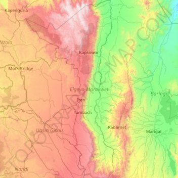
Name: Elgeyo-Marakwet County topographic map, elevation, terrain.
Location: Elgeyo-Marakwet County, Rift Valley, Kenya (0.16787 35.15229 1.31682 35.72309)
Average elevation: 5,676 ft
Minimum elevation: 2,215 ft
Maximum elevation: 11,503 ft
Make a donation
Gear up for your next adventure:
As an Amazon Associate, this site earns from qualifying purchases at no extra cost to you.
Other topographic maps
Click on a map to view its topography, its elevation and its terrain.
Make a donation
Gear up for your next adventure:
As an Amazon Associate, this site earns from qualifying purchases at no extra cost to you.
Make a donation
Gear up for your next adventure:
As an Amazon Associate, this site earns from qualifying purchases at no extra cost to you.
Make a donation
Gear up for your next adventure:
As an Amazon Associate, this site earns from qualifying purchases at no extra cost to you.
Lake Bogoria
There are contradictions regarding its altitude. Unesco's Ramsar gives 963 m (3,159 ft). More precise — and more prudent —, Renaut & Owen 1991 give c. 990 m as of August 1977, but also indicate that the lake's level fluctuates seasonally by 50 to 100 cm; and that it can vary by several meters for short…
Average elevation: 4,324 ft
Make a donation
Gear up for your next adventure:
As an Amazon Associate, this site earns from qualifying purchases at no extra cost to you.
Make a donation
Gear up for your next adventure:
As an Amazon Associate, this site earns from qualifying purchases at no extra cost to you.
Make a donation
Gear up for your next adventure:
As an Amazon Associate, this site earns from qualifying purchases at no extra cost to you.
Make a donation
Gear up for your next adventure:
As an Amazon Associate, this site earns from qualifying purchases at no extra cost to you.
Make a donation
Gear up for your next adventure:
As an Amazon Associate, this site earns from qualifying purchases at no extra cost to you.
Make a donation
Gear up for your next adventure:
As an Amazon Associate, this site earns from qualifying purchases at no extra cost to you.
Make a donation
Gear up for your next adventure:
As an Amazon Associate, this site earns from qualifying purchases at no extra cost to you.
Make a donation
Gear up for your next adventure:
As an Amazon Associate, this site earns from qualifying purchases at no extra cost to you.
Make a donation
Gear up for your next adventure:
As an Amazon Associate, this site earns from qualifying purchases at no extra cost to you.
Make a donation
Gear up for your next adventure:
As an Amazon Associate, this site earns from qualifying purchases at no extra cost to you.
Make a donation
Gear up for your next adventure:
As an Amazon Associate, this site earns from qualifying purchases at no extra cost to you.
Make a donation
Gear up for your next adventure:
As an Amazon Associate, this site earns from qualifying purchases at no extra cost to you.
Kakamega
Kakamega is 52 km north of Kisumu, the tenth largest city in Kenya and considered the heart of Luhya land. The average elevation of Kakamega is 1,535 metres.
Average elevation: 5,030 ft
Make a donation
Gear up for your next adventure:
As an Amazon Associate, this site earns from qualifying purchases at no extra cost to you.
Nakuru
On 3 June 2021, Nakuru was officially endorsed for city status after the Kenyan Senate voted for its elevation from a Municipality. The President of the Republic of Kenya will need to give a city charter for official transformation to city status. If and once given the charter, Nakuru will be the fourth city…
Average elevation: 6,539 ft
Make a donation
Gear up for your next adventure:
As an Amazon Associate, this site earns from qualifying purchases at no extra cost to you.
Make a donation
Gear up for your next adventure:
As an Amazon Associate, this site earns from qualifying purchases at no extra cost to you.
Make a donation
Gear up for your next adventure:
As an Amazon Associate, this site earns from qualifying purchases at no extra cost to you.
Garissa
Garissa has a hot arid climate (Köppen climate classification BWh), despite receiving around 375 millimetres or 15 inches of rainfall per year, due to the extremely high potential evapotranspiration. Garissa's landscape is mostly arid, desert terrain. The city lies along the Tana River, and has a hot climate…
Average elevation: 489 ft
Make a donation
Gear up for your next adventure:
As an Amazon Associate, this site earns from qualifying purchases at no extra cost to you.
Make a donation
Gear up for your next adventure:
As an Amazon Associate, this site earns from qualifying purchases at no extra cost to you.