
Putnam County topographic map
Click on the map to display elevation.
About this map
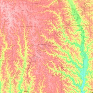
Name: Putnam County topographic map, elevation, terrain.
Location: Putnam County, Missouri, United States (40.34238 -93.38259 40.58957 -92.66434)
Average elevation: 961 ft
Minimum elevation: 751 ft
Maximum elevation: 1,112 ft
Missouri trails, hiking, mountain biking, running and outdoor activities
Other topographic maps
Click on a map to view its topography, its elevation and its terrain.
Simpson Park Lake
United States > Missouri > Saint Louis County > Valley Park
Average elevation: 453 ft
Downtown Kansas City
United States > Missouri > Jackson County > Downtown Kansas City
Average elevation: 889 ft
Pacific Palisades Conservation Area
United States > Missouri > Jefferson County
Average elevation: 499 ft
Dearborn Reservoir Dam
United States > Missouri > Buchanan County > Dearborn
Average elevation: 948 ft
Lake Saint Clair Number Three Dam
United States > Missouri > Franklin County
Average elevation: 705 ft