Geolocate

Kwale topographic map

Interactive map

Click on the map to display elevation.

Kwale

The Coastal Plain, the Foot Plateau, the Coastal Uplands, and the Nyika Plateau are the four principal topographical features of Kwale County.

Wikipedia (CC-BY-SA 3.0)

About this map

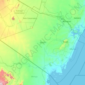
Name: Kwale topographic map, elevation, terrain.

Location: Kwale, Coast, Kenya (-4.79955 38.44879 -3.57197 39.73932)

Average elevation: 925 ft

Minimum elevation: -3 ft

Maximum elevation: 6,604 ft

Other topographic maps

Click on a map to view its topography, its elevation and its terrain.

Githurai

Kenya > Nairobi County

Average elevation: 5,059 ft

Shimba Hills

Kenya > Kwale > Matuga > Kubo South ward

Average elevation: 348 ft

Migori

Kenya > Migori County > Suna West > Ragana-Oruba ward

Average elevation: 4,678 ft

Kapsabet

Kenya > Nandi County > Emgwen

Average elevation: 6,457 ft

South Horr

Kenya > Marsabit County > Laisamis > Kargi/South Horr ward

Average elevation: 3,586 ft

Kenya Gauze

Kenya > Busia County > Bunyala > Bunyala North ward

Average elevation: 3,911 ft

Misori

Kenya > Siaya County > Rarieda > West Uyoma ward

Average elevation: 3,796 ft

Nanighi East

Kenya > Tana River County > Bura

Average elevation: 387 ft

Amboseli

Kenya > Loitokitok > Etonet/Lenkism ward

Average elevation: 3,714 ft

Lake Bogoria

Kenya > Baringo > Mogotio

There are contradictions regarding its altitude. Unesco's Ramsar gives 963 m (3,159 ft). More precise — and more prudent —, Renaut & Owen 1991 give c. 990 m as of August 1977, but also indicate that the lake's level fluctuates seasonally by 50 to 100 cm; and that it can vary by several meters for short…

Average elevation: 4,324 ft

Nakuru

Kenya > Nakuru > Nakuru West

Average elevation: 6,211 ft

Malindi

Kenya > Kilifi County > Malindi

Average elevation: 49 ft

Kitale

Kenya > Trans-Nzoia County > Saboti

Kitale is a town in the north west of Kenya, in the old Rift Valley province. It situated between Mount Elgon and the Cherangany Hills. The town has an elevation of around 1,900 metres (6,200 ft). Its population was 162,174 as of 2019. Kitale town is the headquarter of the Trans-Nzoia County, which is also…

Average elevation: 6,066 ft

Gachoka

Kenya > Embu > Mbeere South

Average elevation: 3,852 ft

Kabuku

Kenya > Kiambu > Limuru > Ngecha Tigoni ward

Average elevation: 7,014 ft

Lugulu

Kenya > Bungoma County > Webuye East > Mihuu ward

Average elevation: 5,318 ft

Ahero Town

Kenya > Kisumu County > Nyando > Ahero ward

Average elevation: 3,783 ft

Jeuri

Kenya > Kilifi County > Kilifi South > Junju ward

Average elevation: 89 ft

Uhanya Beach

Kenya > Siaya County > Bondo > West Yimbo ward

Average elevation: 3,734 ft

MAASAI MARA SEWERAGE

Kenya > Narok North > Narok Town ward > Narok

Average elevation: 6,211 ft

Kigumo

Kenya > Murang'a County > Kigumo

Average elevation: 5,778 ft

MAASAI MARA SEWERAGE

Kenya > Narok North > Narok Town ward > Narok

Average elevation: 6,217 ft

Usonga

Kenya > Siaya County > Alego Usonga > Usonga ward

Average elevation: 3,766 ft

Gap

Kenya > Nakuru > Kuresoi South > Amalo ward

Average elevation: 8,225 ft

Silibwet

Kenya > Nakuru > Kuresoi South > Tinet ward

Average elevation: 8,422 ft

Nyangores

Kenya > Bomet > Chepalungu

Average elevation: 6,227 ft

Syokimau

Kenya > Machakos County > Mavoko

Average elevation: 5,308 ft

Mara

Kenya > Narok > Narok West > Mara ward

Average elevation: 5,105 ft

Ikutha

Kenya > Kitui County > Kitui South

Average elevation: 2,283 ft

Mumias

Kenya > Kakamega County > Mumias West > Mumias Central ward

Average elevation: 4,268 ft

Nyamonye

Kenya > Siaya County > Bondo > Yimbo East ward

Average elevation: 3,819 ft

Nys

Kenya > Nakuru > Naivasha > Naivasha East ward

Average elevation: 7,510 ft

Diani Beach

Kenya > Kwale > Ukunda

Average elevation: 30 ft

Kijabe

Kenya > Kiambu > Lari > Kijabe ward

Average elevation: 7,326 ft

Astu

Kenya > Nakuru > Naivasha > Hells Gate ward

Average elevation: 6,749 ft

Watamu

Kenya > Kilifi County > Kilifi North

Average elevation: 16 ft

Kaathene

Kenya > Meru County > Igembe South

Average elevation: 5,896 ft

Athi

Kenya > Meru County > Igembe South

Average elevation: 5,220 ft

Enkorika

Kenya > Kajiado Central > Dalalekutuk ward

Average elevation: 5,807 ft

Maseno

Kenya > Kisumu County > Kisumu West

Average elevation: 5,030 ft

Kerugoya

Kenya > Kirinyaga County > Kirinyaga Central

Average elevation: 5,092 ft

kiserian oloolaiser water

Kenya > Kajiado North > Kiserian

Average elevation: 6,099 ft

Kamere

Kenya > Nakuru > Naivasha > Olkaria ward

Average elevation: 6,352 ft

Aerial

Kenya > Nakuru > Kuresoi North

Average elevation: 8,871 ft

Nariokotome

Kenya > Turkana County > Spanish Mission

Average elevation: 1,391 ft

Moiben

Kenya > Uasin Gishu County

Average elevation: 6,975 ft

Mathare

Kenya > Nakuru

Average elevation: 7,090 ft

Ruaraka

Kenya > Nairobi County > Nairobi

Average elevation: 5,302 ft

Kiminini

Kenya > Trans-Nzoia County

Average elevation: 5,755 ft

Soweto West

Kenya > Nairobi County

Average elevation: 5,784 ft

Meru

Kenya > Meru County

Average elevation: 5,259 ft

Kutus

Kenya > Kirinyaga County > Mwea East

Average elevation: 4,216 ft

Kitum Cave

Kenya > Trans-Nzoia County

Average elevation: 7,746 ft

Iten

Kenya > Elgeyo-Marakwet County

Average elevation: 7,493 ft

Ngong

Kenya > Kajiado County

As of 2019, the population of Ngong Town consisting of Enchorro-Emunyi and Ngong Township locations is 25,866. The elevation of Ngong town is 1,961 meters in altitude, but the altitude of the hills is about 2,460 meters above sea level. Ngong was the central town of Ngong division while Kajiado County was a…

Average elevation: 6,401 ft

Kobala

Kenya > Homa Bay County

Average elevation: 3,868 ft

Upper Village

Kenya > Kisumu County

Average elevation: 4,088 ft

Kendu Bay

Kenya > Homa Bay County

Average elevation: 3,832 ft

Nairobi Dam

Kenya > Nairobi County > Nairobi

Average elevation: 5,561 ft

Nandi Hills

Kenya > Nandi County

Nandi Hills is located in a highland area of lush green rolling hills at the edge of the Great Rift Valley in the southwestern part of Kenya. It is located approximately 303 kilometres (188 mi), by road, northwest of Nairobi, the capital and largest city in the country. The coordinates of Nandi Hills, Kenya…

Average elevation: 6,654 ft

Thika

Kenya > Kiambu > Thika Town

Average elevation: 4,905 ft

Kagondo

Kenya > Nairobi County > Nairobi

Average elevation: 6,224 ft

Kakamega

Kenya > Kakamega County

Kakamega is 52 km north of Kisumu, the tenth largest city in Kenya and considered the heart of Luhya land. The average elevation of Kakamega is 1,535 metres.

Average elevation: 5,030 ft

Satelite

Kenya > Nakuru

Average elevation: 6,010 ft

Machakos

Kenya > Machakos County

Average elevation: 5,466 ft

County Concil

Kenya > Nakuru

Average elevation: 8,881 ft

Silali

Kenya > Turkana County

Average elevation: 3,310 ft

Birikani

Kenya > Taita–Taveta

Average elevation: 1,860 ft

Garissa

Kenya > Garissa

Garissa has a hot arid climate (Köppen climate classification BWh), despite receiving around 375 millimetres or 15 inches of rainfall per year, due to the extremely high potential evapotranspiration. Garissa's landscape is mostly arid, desert terrain. The city lies along the Tana River, and has a hot climate…

Average elevation: 489 ft

Lake

Kenya > Nairobi County > Nairobi

Average elevation: 6,135 ft

Sotik

Kenya > Nakuru

Average elevation: 8,130 ft

Fire

Kenya > Nakuru > Fire

Average elevation: 6,010 ft

Nairobi

Kenya > Nairobi > Nairobi

Average elevation: 5,656 ft

Kaptagat

Kenya > Elgeyo-Marakwet County > Kaptagat

Average elevation: 7,956 ft

Kiangai

Kenya > Nakuru > Kiangai

Average elevation: 6,362 ft

Kikuyu

Kenya > Kiambu > Kikuyu

Average elevation: 6,568 ft

Maralal

Kenya > Samburu

Average elevation: 6,417 ft

Naro Moru

Kenya > Nyeri

Average elevation: 6,742 ft

Hola

Kenya > Tana River > Hola

Average elevation: 207 ft

Nachu

Kenya > Kiambu > Nachu

Average elevation: 6,089 ft

Eldoret

Kenya > Uasin Gishu County > Moiben

Eldoret is the fifth largest city in Kenya. It is located in Uasin Gishu County, in the Rift Valley region and serves as the capital of Uasin Gishu County. The town was referred to by white settlers as Farm 64 and colloquially by locals as 'Sisibo'. As per the 2019 Kenya Population and Housing Census, Eldoret…

Average elevation: 6,867 ft

Kangundo

Kenya > Machakos > Kangundo

Average elevation: 5,203 ft

Forest Road

Kenya > Nakuru > Forest Road

Average elevation: 6,588 ft

Litein

Kenya > Kericho > Litein

Average elevation: 6,312 ft

Voi

Kenya > Taita Taveta > Voi

Average elevation: 1,857 ft

Athi River

Kenya > Machakos County > Mavoko

Average elevation: 4,987 ft

Nakuru

Kenya > Nakuru > Nakuru

On 3 June 2021, Nakuru was officially endorsed for city status after the Kenyan Senate voted for its elevation from a Municipality. The President of the Republic of Kenya will need to give a city charter for official transformation to city status. If and once given the charter, Nakuru will be the fourth city…

Average elevation: 6,539 ft

Kiambu

Kenya > Kiambu > Kiambu

Average elevation: 5,646 ft

Magadi

Kenya > Kajiado County > Magadi

Average elevation: 2,103 ft

Rombo

Kenya > Loitokitok > Rombo ward

Average elevation: 3,839 ft

Dadaab

Kenya > Garissa

Average elevation: 413 ft

Ongata Rongai

Kenya > Kajiado County

Average elevation: 5,712 ft

Narok

Kenya > Narok > Narok

Average elevation: 6,250 ft

Gombato

Kenya > Kwale > Gombato

Average elevation: 52 ft

Thiba

Kenya > Kirinyaga County > Thiba

Average elevation: 3,776 ft

Athi River

Kenya > Kiambu County

Average elevation: 5,187 ft

Gonja

Kenya > Kwale > Gonja

Average elevation: 341 ft

Ruiru

Kenya > Kiambu County > Ruiru

Average elevation: 5,023 ft

Khwisero

Kenya > Kakamega > Khwisero

Average elevation: 4,734 ft