
Sedgwick County topographic map
Interactive map
Click on the map to display elevation.
About this map
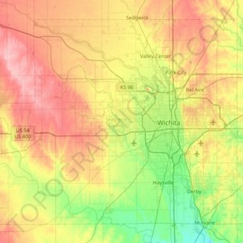
Name: Sedgwick County topographic map, elevation, terrain.
Location: Sedgwick County, Kansas, United States (37.47418 -97.80836 37.91273 -97.15215)
Average elevation: 1,371 ft
Minimum elevation: 1,207 ft
Maximum elevation: 1,581 ft
Kansas trails, hiking, mountain biking, running and outdoor activities
Other topographic maps
Click on a map to view its topography, its elevation and its terrain.
Opolis
United States > Kansas > Crawford County
Opolis is located in the South Eastern corner of the state of Kansas close to the Missouri state line, approximately 133 miles (210 km) .due south of Kansas City, KS at latitude 37.344 and longitude -94.621. It has an estimated population of 117 with 54 houses (based on a zipcode estimate from the year 2000)…
Average elevation: 919 ft
Wyandotte County Lake
United States > Kansas > Wyandotte County > Kansas City > Vinewood
Average elevation: 889 ft
Lawrence
United States > Kansas > Douglas County > Lawrence
Downtown Lawrence is located at 38°58′18″N 95°14′7″W / 38.97167°N 95.23528°W / 38.97167; -95.23528 (38.959902, −95.253199), approximately 25 miles (40 kilometers) east of Topeka, and 35 mi (56 km) west of Kansas City, Kansas. Though Lawrence has a designated elevation of 866 feet (264…
Average elevation: 928 ft
Overland Park Arboretum and Botanical Gardens
United States > Kansas > Johnson County > Overland Park
Average elevation: 1,001 ft
Mount Mitchell Heritage Prairie Park
United States > Kansas > Wabaunsee County > Wamego
Average elevation: 1,066 ft
Valley Center
United States > Kansas > Sedgwick County > Valley Center > Valley Center
Average elevation: 1,362 ft
Valley Falls
United States > Kansas > Jefferson County > Valley Falls > Valley Falls
Average elevation: 971 ft
Arkansas City
United States > Kansas > Cowley County > Arkansas City > Arkansas City
Average elevation: 1,112 ft
Cottonwood Falls
United States > Kansas > Chase County > Cottonwood Falls > Cottonwood Falls
Average elevation: 1,243 ft